Valid Sun Jul 21, 2024
Valid Mon Jul 22, 2024
Valid Tue Jul 23, 2024
+ Additional Links
- » Description of the National Forecast Chart
- » Product Archives
- » Download hazards in KML or shapefile format or GeoJSON format
![Day 1 image not available](/archives/sfc/2024/namussfc2024072100.gif)
![Day 2 image not available](/sfc/namussfc03wbg.gif)
![Day 3 image not available](/sfc/namussfc06wbg.gif)
![Day 4 image not available](/sfc/namussfc09wbg.gif)
![Day 5 image not available](/sfc/namussfc12wbg.gif)
![Day 6 image not available](/sfc/namussfc15wbg.gif)
![Day 7 image not available](/sfc/namussfc18wbg.gif)
![Day 8 image not available](/sfc/namussfc21wbg.gif)
![Day 9 image not available](/sfc/namussfc00wbg.gif)
![Day 1 image not available](../sfc/usfntsfc00wbg.gif)
![Day 2 image not available](../basicwx/93fndfd_init_2024072112.gif
)
![Day 3 image not available](../basicwx/94fndfd_init_2024072112.gif
)
![Day 4 image not available](../basicwx/95fndfd_init_2024072112.gif
)
![Day 5 image not available](../basicwx/96fndfd_init_2024072112.gif
)
![Day 6 image not available](../basicwx/98fndfd_init_2024072112.gif
)
![Day 7 image not available](../basicwx/99fndfd_init_2024072112.gif
)
![Day 8 image not available](../medr/display/wpcwx+frontsf072.gif)
![Day 9 image not available](../medr/display/wpcwx+frontsf096.gif)
![Day 10 image not available](../medr/display/wpcwx+frontsf120.gif)
![Day 11 image not available](../medr/display/wpcwx+frontsf144.gif)
![Day 12 image not available](../medr/display/wpcwx+frontsf168.gif)
NWS Weather Prediction Center College Park MD
400 PM EDT Sun Jul 21 2024
Valid 00Z Mon Jul 22 2024 - 00Z Wed Jul 24 2024
...Excessive, potentially dangerous heat continues over much of the
western U.S....
...Monsoonal thunderstorms continue across the Four Corners region with
the risk for flash flooding...
....A stalled frontal boundary will bring additional thunderstorm chances
from the Mid-Atlantic to the southern Plains, where scattered instances of
flash flooding will be possible...
Widespread areas of hazardous, potentially dangerous heat continue over
much of the West today (Sunday) as a strong upper-level ridge remains in
place and temperatures soar into the 100s for many locations. The heat is
expected to continue into next week, focusing on portions of interior
California, the Great Basin, and the northern Rockies Monday with
widespread highs in the mid-90s to 100s. An upper-level low over the
northeastern Pacific and accompanying surface front will bring some relief
from the excessive heat to the northern Great Basin by Tuesday, with highs
closer to mid-summer averages. However, the upper-level ridge will also
shift eastward ahead of the trough, helping to spread hotter temperatures
into portions of the northern High Plains, with highs into the upper 90s.
Some daily record highs will be possible over the next couple days, with
warm, well-above average morning lows providing little relief from the
heat overnight.
Elsewhere in the West, periodic shortwave energy on the eastern side of
the ridge will continue to bring daily thunderstorm chances to the Four
Corners Region. Sufficient moisture in place will promote some locally
heavy downpours with the risk for scattered instances of flash flooding. A
Slight Risk of Excessive Rainfall (level 2/4) remains in place Sunday for
portions of southeastern Arizona, much of New Mexico, south-central
Colorado, and portions of west Texas. The upper-level ridge will shift
eastward over the next couple of days, bringing somewhat drier conditions
and limiting the upper-level energy, with more scattered thunderstorm
chances. However, there will still be an isolated threat for flash
flooding, with the greatest chance on Monday over the higher terrain of
south-central Colorado into central New Mexico, where another Slight Risk
of Excessive Rainfall is in place as some of these areas remain more
sensitive due to burn scars.
To the east, a quasi-stationary frontal boundary draped from the
Mid-Atlantic southwest through the Tennessee Valley/Southeast and into the
Lower Mississippi Valley and southern Plains will remain the focus for
additional widespread thunderstorms and heavy rain over the next couple of
days. Anomalously high moisture as well as expected slow storm motions
will bring the greatest risk for flash flooding to the Southern Plains,
with a Slight Risk of Excessive Rainfall Monday from the ArkLaTexas
southwest into western Texas. Another Slight Risk is in effect Tuesday
mainly over portions of eastern and central Texas. Further east, more
scattered, less organized storms will still pose a threat for some
isolated flash flooding, with a potentially locally higher threat for
urban areas. The frontal boundary will lift northward a bit by later
Monday, helping to spread storm chances further north into the Interior
Northeast and New England Monday evening and into the day Tuesday.
Elsewhere, another frontal system passing through the Upper-Midwest will
bring thunderstorm chances over the next couple of days here as well, with
some moderate to locally heavy rainfall possible.
Putnam
Graphics available at
https://www.wpc.ncep.noaa.gov/basicwx/basicwx_ndfd.php
NWS Weather Prediction Center College Park MD
250 PM EDT Sun Jul 21 2024
Valid 12Z Wed Jul 24 2024 - 12Z Sun Jul 28 2024
***Western U.S. heat wave to become more pronounced over the
northern High Plains while moderating elsewhere, and
showers/storms with heavy rainfall expected from the Four Corners
to portions of the East***
19Z Update: The 12Z models maintain very good synoptic scale
agreement through the end of the week, and guidance has improved
with the shortwave/upper low crossing southern Canada. The GFS had
been a progressive solutions on earlier runs, but is now more in
line with the model consensus. The NBM still appeared too light
with convective QPF across many areas, including the Desert
Southwest and also across portions of the Gulf Coast region, so
these values were increased with incorporation of the deterministic
GFS and ECMWF. A slight Risk area will be introduced for the Day 5
period across portions of the Carolinas and into southern Virginia.
By next weekend, the CMC becomes more amplified with the trough
exiting the East Coast and stronger with a trough across the
Central Plains, but relatively comparable elsewhere, and the ECMWF
is slower for the trough to exit the East Coast. Given the good
overall agreement even through next weekend, the use of the
ensemble means was only increased to about 30% by that time, with
the majority composing deterministic guidance and a little of
previous WPC continuity. The previous forecast discussion is
appended below for reference. /Hamrick
------------------------
...General Overview...
Latest guidance continues to show a steady transition toward a more
typical summertime mean pattern after starting out fairly amplified
at the start of the period early Wednesday. Expect the strong
ridge initially over the West (producing hazardous heat from the
West into the northern High Plains) to become weaker and more
suppressed as a Pacific upper low tracks across southwestern Canada
and residual troughing sets up along the West Coast. Monsoonal
moisture will contribute to daily episodes of showers/storms over
the Four Corners states into the Great Basin. Some of this
moisture may eventually interact with a front pushing into the
northern Plains as Canadian dynamics continue eastward. Meanwhile,
one or more wavy fronts will be on the leading side of Great Lakes
into southern Plains mean troughing aloft, leading to multiple
days of rain/thunderstorms with areas of heavy rainfall from the
southern Plains into the Mid-Atlantic and parts of New England.
The Great Lakes and Northeast should eventually trend drier late
week as the northern part of the trough moves eastward, but a more
persistent upper level weakness over the Plains may continue to
generate episodes of rainfall farther south. Atlantic upper
ridging should build into the Southeast for a time, peaking in
strength around Wednesday-Thursday. Southeast ridging may rebuild
by next Sunday.
...Guidance/Predictability Assessment...
The most prominent forecast issue continues to involve the mid-late
week trough crossing the Great Lakes and Northeast. Through the
12Z/18Z cycles, the array of guidance remained similar to the past
couple days with the ECMWF/ECens mean on the slow side and GFS runs
fairly fast and open with the UKMET/CMC in the middle. The CMCens
mean tilted to the slower side as well but ECMWF-initialized
machine learning (ML) models have consistently been in the middle
to faster part of the spread--at least favoring somewhat of a lean
away from the slow 12Z ECMWF. The new 00Z ECMWF has arrived with a
significantly faster/open trend. Farther west, as the western
Canadian upper low continues eastward and possibly opens up later
next weekend, the 18Z GFS strayed a bit south/southeast of
consensus with the upper low, bringing greater height falls across
the northern tier U.S. Thus the 18Z GFS could be overdone with the
southward extent of the leading cold front. The new 00Z GFS looks
better in that regard. The overall array of guidance supported an
intermediate solution among 12Z/18Z operational models early in the
period and then a transition toward approximately half models/half
means late in the period.
...Weather/Hazards Highlights...
Dangerous heat over the West/northern Rockies should extend at
least into midweek with high temperatures reaching the 90s and
100s and warm overnight lows providing only limited relief. After
decent coverage of plus 5-15F anomalies for highs on Wednesday,
some cooling will likely move in from the West Coast (bringing
highs within a few degrees on either side of normal) as moderate
upper troughing sets up near the coast. Meanwhile, forecasts
continue to show the most anomalous heat shifting into
Montana and the northern High Plains during mid-late week. In
particular during Wednesday-Thursday the experimental HeatRisk
index shows fairly broad coverage of major risk of heat-related
impacts. A few daily records will be possible as well. The
prolonged period of dry heat over the West extending into this week
could also result in enhanced wildfire danger. In contrast, the
cloudy and wet pattern over portions of the South and East will
tend to keep highs below normal from Texas east-northeastward, with
greatest coverage of negative anomalies Wednesday-Friday (and
coolest versus normal over Texas/Louisiana). Southern and eastern
Texas may remain below normal into the weekend.
Monsoonal moisture will continue to support episodes of diurnally
favored convection over the Four Corners region into the Great
Basin, with some shifting of coverage over the course of the period
based on pattern evolution. Isolated to scattered instances of
flash flooding will be possible, especially near steep terrain and
burn scars. The Day 4 Excessive Rainfall Outlook valid on Wednesday
has expanded the Marginal Risk area northwestward based on guidance
signals and favorable combination of anomalous moisture and
instability (especially in the GFS) and proximity of a wavy front.
The Day 5 ERO for Thursday reflects guidance consensus of moisture
pushing eastward given southwesterly mean flow aloft. Potential
remains for embedded Slight Risk upgrades entering the short range
period depending on how guidance clusters relative to each other
and with sensitive burn scar areas/regions with wettest ground
conditions. Toward late week through the weekend, some of this
moisture may interact with the front progressing across the
northern Plains to produce some areas of focused rainfall.
The upper trough extending from the Great Lakes into southern
Plains and one or more leading wavy fronts will support a broad
corridor of locally heavy shower and thunderstorm potential from
the southern Plains northeastward next week. The best guidance
signals in terms of coherence and rainfall magnitude (with ample
moisture and instability) persist over southern/southeastern Texas
on Wednesday, although the latest trend has been for a more
southward progression and closer to the coast. Thus the planned
Day 4 ERO update will be scaled back some on the northern extent
of the existing Slight Risk area depicted over this region. The
surrounding Marginal Risk area extends northeastward through the
Mid-Atlantic and southern New England, although the overall risk
area has been made a little more narrow to account for latest model
trends.
The Day 5 ERO valid on Thursday depicts a broad Marginal
Risk area from southern/eastern Texas through the South and into
the Northeast, with persistence of the corridor of enhanced
moisture from Day 4 and potential interaction of the Great Lakes
system (with its separate Marginal Risk area on Day 4) with this
moisture over the Mid-Atlantic and into the Northeast. A Slight
Risk area is now planned from the upstate of South Carolina to the
greater Richmond metro area of Virginia, with this region expected
to have multiple rounds of heavy rainfall in the days leading up to
this. Expect the Great Lakes/Northeast to trend drier late week
into the weekend while showers and thunderstorms of varying
intensity will likely persist into the weekend over the southern
tier.
Rausch
Additional 3-7 Day Hazard information can be found on the WPC
medium
range hazards outlook chart at:
https://www.wpc.ncep.noaa.gov/threats/threats.php
WPC medium range 500mb heights, surface systems, weather grids,
quantitative precipitation forecast (QPF), excessive rainfall
outlook (ERO), winter weather outlook (WWO) probabilities, heat
indices, and Key Messages can be accessed from:
https://www.wpc.ncep.noaa.gov/medr/5dayfcst500_wbg.gif
https://www.wpc.ncep.noaa.gov/medr/5dayfcst_wbg_conus.gif
https://www.wpc.ncep.noaa.gov/5km_grids/5km_gridsbody.html
https://www.wpc.ncep.noaa.gov/qpf/day4-7.shtml
https://www.wpc.ncep.noaa.gov/#page=ero
https://www.wpc.ncep.noaa.gov/wwd/pwpf_d47/pwpf_medr.php?day=4
https://www.wpc.ncep.noaa.gov/heat_index.shtml
https://www.wpc.ncep.noaa.gov/#page=ovw
Hawaii Extended Forecast Discussion
NWS Weather Prediction Center College Park MD
348 AM EDT Sun Jul 21 2024
Valid 00Z Mon Jul 22 2024 - 00Z Mon Jul 29 2024
Guidance continues to show high pressure near 40N latitude being
the primary influence on the trades for most of the coming week.
This high will drift east and strengthen into the first part of
the week, followed by a westward return along with eventual
weakening by next Saturday-Sunday. Initially moderate trades will
likely trend toward brisk/windy conditions mid-late week with some
moderation next weekend. A deepening weakness aloft north and
west of the state may also help to slacken the pressure gradient
next weekend. A modest pocket of moisture crossing the area this
weekend will give way to a drier trend on Monday, followed by
another area of enhanced moisture crossing the region
Tuesday-Wednesday. This moisture may consist of two distinct
pockets of higher precipitable water values, as ECMWF-based
guidance was suggesting 24 hours ago with the GFS now trending in
that direction. This moisture should help to provide some
enhancement to the prevailing windward/mountain-focused showers.
Guidance still suggests there will be a drier period from late
week into the weekend.
Rausch
![Day 1 image not available](../qpf/fill_94qwbg.gif)
![Day 2 image not available](../qpf/fill_98qwbg.gif)
![Day 3 image not available](../qpf/fill_99qwbg.gif)
![Day 4 image not available](../qpf/day4p24iwbg_fill.gif)
![Day 5 image not available](../qpf/day5p24iwbg_fill.gif)
![Day 6 image not available](../qpf/day6p24iwbg_fill.gif)
![Day 7 image not available](../qpf/day7p24iwbg_fill.gif)
![Day 8 image not available](../qpf/d12_fill.gif)
![Day 9 image not available](../qpf/d13_fill.gif)
![Day 10 image not available](../qpf/p120i.gif)
![Day 11 image not available](../qpf/p168i.gif)
![Day 1 image not available](../qpf/hpcqpf_2024072200_12hr_f012.gif
)
![Day 2 image not available](../qpf/hpcqpf_2024072200_12hr_f018.gif
)
![Day 3 image not available](../qpf/hpcqpf_2024072200_12hr_f024.gif
)
![Day 4 image not available](../qpf/hpcqpf_2024072200_12hr_f030.gif
)
![Day 5 image not available](../qpf/hpcqpf_2024072200_12hr_f036.gif
)
![Day 6 image not available](../qpf/hpcqpf_2024072200_12hr_f042.gif
)
![Day 7 image not available](../qpf/hpcqpf_2024072200_12hr_f048.gif
)
![Day 8 image not available](../qpf/hpcqpf_2024072200_12hr_f054.gif
)
![Day 9 image not available](../qpf/hpcqpf_2024072200_12hr_f060.gif
)
![Day 10 image not available](../qpf/hpcqpf_2024072200_12hr_f066.gif
)
![Day 11 image not available](../qpf/hpcqpf_2024072200_12hr_f072.gif
)
![Day 1 image not available](../qpf/fill_92ewbg.gif)
![Day 2 image not available](../qpf/fill_93ewbg.gif)
![Day 3 image not available](../qpf/fill_9eewbg.gif)
![Day 4 image not available](../qpf/fill_9fewbg.gif)
![Day 5 image not available](../qpf/fill_9gewbg.gif)
![Day 6 image not available](../qpf/fill_9hewbg.gif)
![Day 7 image not available](../qpf/fill_9iewbg.gif)
![Day 8 image not available](../qpf/fill_9jewbg.gif)
![Day 9 image not available](../qpf/fill_9kewbg.gif)
![Day 10 image not available](../qpf/fill_9lewbg.gif)
![Day 11 image not available](../qpf/fill_9oewbg.gif)
![Day 12 image not available](../qpf/fill_9newbg.gif)
![Day 1 image not available](../qpf/95ep48iwbg_fill.gif)
![Day 2 image not available](../qpf/97ep48iwbg_fill.gif)
» Extreme Precipitation Monitor
+ Additional Links
- » Product Verification
- » Product Archive
- » Product Info
- » Additional formats of QPF: GRIB 2 | Shapefiles | KML
- » Other QPF Products
![Day 1 image not available](../qpf/94ewbg.gif)
![Day 2 image not available](../qpf/98ewbg.gif)
![Day 3 image not available](../qpf/99ewbg.gif)
![Day 4 image not available](../qpf/ero_d45/images/d4wbg.gif)
![Day 5 image not available](../qpf/ero_d45/images/d5wbg.gif)
+ Forecast Discussion
Excessive Rainfall Discussion
NWS Weather Prediction Center College Park MD
750 PM EDT Sun Jul 21 2024
Day 1
Valid 01Z Mon Jul 22 2024 - 12Z Mon Jul 22 2024
...THERE IS A SLIGHT RISK FOR EXCESSIVE RAINFALL ACROSS PORTIONS OF
THE SOUTHWEST AND THE WESTERN CAROLINAS...
...Western Carolinas...
Some southward shift to the Slight Risk area was done per radar and
18z HREF trends. Another round of scattered to widespread
convection is ongoing in and near the Carolinas with some
locations setup to see a greater emphasis for heavy rainfall. A few
weak mid- level perturbations will advect northeast within the
mean flow. The coupling of increased upper support with a strong
diurnal destabilization pattern has promoted the threat of
stronger cell cores with heavy rain potential due to anomalous
moisture lingering along and south of the quasi- stationary front
to the north. Convection firing along the terrain of the
escarpment up through the Appalachians of NC should drift to the
east towards lower elevations. Locally enhanced rainfall exceeding
2" in an hour remains high for much of Western NC down into the
far Upstate portion SC to the north of GSP in the short term.
This area has seen its fair share of heavy rain in the past 24-48
hrs at times, so the latest FFGs are lower than climo.
...Southwest and Southern Rockies...
Divergence aloft between an upper low offshore the Northwest and an
upper level trough across the Plains combined with daytime heating
has led to convective development in- of the Southern Rockies and
adjacent terrain of NM due to primed environmental destabilization
coinciding with a progression of mid- level vortices streaming down
the eastern flank of the ridge across the Western U.S. A slight
weakening of the ridge will allow for an expansion of the
convective threat to migrate westward into the Mogollon Rim with
some deterministic output signaling some formidable amounts within
the terrain. The primary areas of interest within the current SLGT
will reside within the complex terrain and areas surrounding the
remnant burn scars located within the Sacramento's and Sangre de
Cristos. Secondary areas of focus include the NM Bootheel,
Southeast AZ terrain around the Huachucas, as well as the Eastern
NM High Plains into the Northwest Permian Basin of Texas.
The latter of the aforementioned areas has a focus along a remnant
outflow that bisect the Caprock down into the Permian Basin,
outlined by a marginal theta-E gradient in place from Clines
Corner, NM down close to I-20 around the Midland/Odessa corridor. A
shortwave currently analyzed over CO will continue to make headway
to the south around the eastern flank of the ridge eventually
aiding in convective initiation across east-central NM by the
afternoon. Multi-cell clusters of thunderstorms have been
congealing and driven south by prevailing cold pools, riding right
along the theta-E gradient. Storms will be able to hold together
and impact a large area encompassing the Caprock of Eastern NM down
through the Northwest Permian Basin before potentially collapsing
tonight. There is a chance this holds together to the I-20
corridor and provides some heavier rain within the confines of the
Midland/Odessa area, but the probability is lower compared to the
Northwestern areas up across Southeastern NM up through the Caprock
along the TX/NM state lines. Despite a very dry signal within the
soil moisture availability over the region, rainfall rates in
excess of 1.5"/hr will be plausible given the elevated moisture
presence as noted within the latest NAEFS PWAT anomalies
approaching 1-1.5 deviations above normal across much of Southeast
NM extending southeastward into the quasi-stationary front aligned
near I-10. Some adjustments were made due to radar reflectivity and
18z HREF trends.
...Oklahoma...
A compact but well-defined surface wave will linger
within the base of the mean trough carved out across the Mid-
Mississippi Valley back down into the northern fringes of the
Southern Plains in OK. Signals for increasing low-level
convergence within the confines of low are present, leading to a
narrow corridor of heavy rain that could see totals breach 4"
within a short period of time. The main threat is confined within
the small circulation with the northern fringes of the low being
the prime focus for where modest training could occur. The areal
extent of flash flood concerns is small due to the compact nature
of the setup.
Roth/Kleebauer
Day 1 threat area: www.wpc.ncep.noaa.gov/qpf/94epoints.txt
Excessive Rainfall Discussion
NWS Weather Prediction Center College Park MD
750 PM EDT Sun Jul 21 2024
Day 2
Valid 12Z Mon Jul 22 2024 - 12Z Tue Jul 23 2024
...THERE IS A SLIGHT RISK FOR EXCESSIVE RAINFALL ACROSS PORTIONS OF THE
SOUTHERN ROCKIES, TEXAS THROUGH THE ARKLATEX...
21Z Excessive Rainfall Discussion
The large scale pattern continues to shift slowly during the
period...with a quasi-stationary front continuing to be one of the
main features to focus and sustain convection capable of producing
downpours that results in flash flooding. The previous outlook
still had the support of the HREF probability guidance...so only
minor tweaks were needed,
Bann
Previous Excessive Rainfall Discussion
...Southern Plains...
A quasi-stationary front will bisect much of the state of Texas
with a westward extension into the Southwest TX terrain back
through the Big Bend, Edwards Plateau, Hill Country, all the way
out to the ArklaTex. Mid-level energy from the northwest will
navigate southeast towards the higher terrain south of I-20,
migrating slowly eastward within the confines of the front. The
added upper forcing in conjunction with the increasing low-level
convergence along the stationary front will induce a swath of
stronger thunderstorms capable of significant rainfall within any
cell core. Latest NAEFS PWAT anomalies signals a solid +2
deviations from climo for the moisture field present across much of
the central portions of TX back into the Stockton Plateau. Cell
initiation across the higher terrain out west will lead to
convective clustering with outflow generation stemming from areal
thunderstorm coverage, eventually propagating to the east into the
I-35 corridor in Central TX by later Monday afternoon and evening.
Precip totals within the initial cell development are generally
between 1-2", but some higher totals exceeding 4" will be possible
across the Lower Trans Pecos through the Southern Edwards Plateau.
The heaviest core of precip will lie within the eastern extent of
the Edwards Plateau across into Hill Country until it reaches the
I-35 corridor near Austin/San Antonio. This is where ensemble mean
QPF has been the most consistent for totals exceeding 2" with
indications of up to 3" in areal average QPF within Hill Country
and individual deterministic output exceeding 6" in places hit with
repeated cells. Mean storm motions within the confines of the
boundary are weak meaning slow moving convective clusters with
rainfall rates between 2-3"/hr are possible along that frontal
boundary. The SLGT risk from previous forecast was maintained but
expanded to the west to include more of the Stockton Plateau given
the latest trends within the mean QPF and favorable environment
over the area leading into the evolving event.
Further to the northeast through Northeast TX into the ArklaTex,
energy from the southwest will eventually advect northeastward with
convective generation during the afternoon and evening hours
becoming more organized with the additional upper support. Some
cell clusters will be capable of locally heavy rainfall extending
along the stationary front with some convective training plausible
due to similar conditions from upstream. Totals are not as prolific
within the means across the above region, but some totals of 2-4"
are not out of the question, so felt there was no reason to make
significant adjustments to the previously inherited SLGT risk.
...Southwest and Southern Rockies...
Scattered thunderstorms will develop once again within the confines
of the Sangre de Cristos with highest impacts situated over the
complex terrain and any burn scars within the mountain chain.
Totals are not expected to be as prolific compared to recent days
with less of a favorable mid-level pattern and lower SBCAPE
forecast. Regardless, considering the expected convective
development and the very sensitive nature of the flash flooding
potential within the burn scars, there was enough merit to continue
the focused SLGT risk across the Mountains with an extension down
into the Sacramento's due to the ongoing issues caused by the burn
scarring near Ruidoso. This is a lower end SLGT risk threshold with
impact based reasoning for the risk continuity.
Across the rest of the Southwestern U.S, the upper pattern will
shift to have less ridge potency leading to an expansion of the
convective risks a bit further west to include the Lower Colorado
River valley between CA/AZ/NV. The best threat will still be across
the Mogollon Rim where scattered thunderstorm coverage will likely
spawn some totals exceeding 1" within a short period of time along
the terrain of central AZ. The coverage and moisture anomalies were
not primed enough to warrant an upgrade at this time, but the
threat is still a mid to higher end MRGL risk, on the cusp of a
potential upgrade if the setup becomes more pronounced within the
means.
...Southeast to Southern Mid Atlantic...
Persistent surface front bisecting much of the Southeastern U.S up
through the Southern Mid Atlantic will continue the threat of
scattered thunderstorms capable of locally heavy rainfall with some
training prospects within the confines of the quasi-stationary
boundary. The QPF footprint is a shotgun of small QPF maxima
reflective of the potential with less of any organized threat and
more of a widespread convective pattern that favors some locally
greater impacts, but remaining on the low to middle grounds of the
MRGL threshold. The one area of note for a potentially more
impactful setup is across the Central Mid Atlantic where a stronger
shortwave will advect northeast out of the Carolina's with
increased upper forcing traversing the DC/Baltimore metro area
during the middle of peak diurnal instability. Recent deterministic
output is a bit more robust compared to recent forecasts and is in
agreement with the ML output based within the GFS Graphcast and
ECMWF AIFS. It will be interesting to see the trends as we move
into the CAMs window because there could be a targeted SLGT risk
within the urban corridor if the signal holds. A MRGL risk is in
effect, but will be monitoring closely.
Kleebauer
Day 2 threat area: www.wpc.ncep.noaa.gov/qpf/98epoints.txt
Excessive Rainfall Discussion
NWS Weather Prediction Center College Park MD
750 PM EDT Sun Jul 21 2024
Day 3
Valid 12Z Tue Jul 23 2024 - 12Z Wed Jul 24 2024
...THERE IS A SLIGHT RISK FOR EXCESSIVE RAINFALL ACROSS PORTIONS OF
TEXAS...
21Z Excessive Rainfall Discussion
Few changes needed to on-going EROs given latest deterministic and
ensemble runs from 12Z.
Bann
Previous Excessive Rainfall Discussion
...Southern Plains...
A repeat of heavy convection across TX is forecast as the quasi-
stationary front within deep moisture anomalies remains parked
across much of Central and Eastern TX. Latest ensemble bias
corrected QPF is signaling an additional 2-3" possible within the
I-35 corridor with some scattered heavy rain signals all the way
back into the Central RGV from Del Rio down towards Laredo. Weak
mean storm motions and rates likely pushing 2-3"/hr will allow for
more significant flooding potential over areas that will have been
hit the prior period. In fact, 48-hr QPF could top 6" in spots
within the two successive periods which would allow for significant
issues to arise if it falls across the I-35 corridor. A SLGT risk
was maintained and expanded across the western flank of the risk
area to account for trends in the ensemble QPF footprint and better
instability fields located out towards the RGV. If the previous
period ends up with more significant impacts, this could lead to an
upgrade in the forecast risk over portions of Central TX.
...Southern Rockies and Southwest...
Monsoonal convection will encompass much of the Southwest U.S with
primary coverage in the Great Basin as the mid-level ridge pattern
shifts focus to the west of the Four Corners. Modest moisture
anomalies and relatively formidable instability across much of the
region will allow for scattered thunderstorms with isolated heavy
rain cores that could spell issues if they fall along complex
terrain, burn scars, urban footprints, and slot canyons. A MRGL
risk is in effect across much of the climatologically favored
areas in the Southwestern Monsoon.
...Upper Midwest...
Shortwave trough moving through the Great Lakes will allow for the
initiation of organized convection as it pivots through the region.
Modest instability and moisture anomalies in the confines of the
Lakes will lead to some scattered heavy rain signals as the
disturbance traverses the area. The progressive nature of the
system will limit widespread flash flooding concerns, but a few
isolated heavier cores could pose some issues for more urbanized
areas across Northern and Central WI into the Michigan UP. A low-
end MRGL is in effect for the above area.
Kleebauer
Day 3 threat area: www.wpc.ncep.noaa.gov/qpf/99epoints.txt
NWS Weather Prediction Center College Park MD
250 PM EDT Sun Jul 21 2024
Dangerous heat over the West/northern Rockies should extend at
least into midweek with high temperatures reaching the 90s and
100s and warm overnight lows providing only limited relief. After
decent coverage of plus 5-15F anomalies for highs on Wednesday,
some cooling will likely move in from the West Coast (bringing
highs within a few degrees on either side of normal) as moderate
upper troughing sets up near the coast. Meanwhile, forecasts
continue to show the most anomalous heat shifting into
Montana and the northern High Plains during mid-late week. In
particular during Wednesday-Thursday the experimental HeatRisk
index shows fairly broad coverage of major risk of heat-related
impacts. A few daily records will be possible as well. The
prolonged period of dry heat over the West extending into this week
could also result in enhanced wildfire danger. In contrast, the
cloudy and wet pattern over portions of the South and East will
tend to keep highs below normal from Texas east-northeastward, with
greatest coverage of negative anomalies Wednesday-Friday (and
coolest versus normal over Texas/Louisiana). Southern and eastern
Texas may remain below normal into the weekend.
Monsoonal moisture will continue to support episodes of diurnally
favored convection over the Four Corners region into the Great
Basin, with some shifting of coverage over the course of the period
based on pattern evolution. Isolated to scattered instances of
flash flooding will be possible, especially near steep terrain and
burn scars. The Day 4 Excessive Rainfall Outlook valid on Wednesday
has expanded the Marginal Risk area northwestward based on guidance
signals and favorable combination of anomalous moisture and
instability (especially in the GFS) and proximity of a wavy front.
The Day 5 ERO for Thursday reflects guidance consensus of moisture
pushing eastward given southwesterly mean flow aloft. Potential
remains for embedded Slight Risk upgrades entering the short range
period depending on how guidance clusters relative to each other
and with sensitive burn scar areas/regions with wettest ground
conditions. Toward late week through the weekend, some of this
moisture may interact with the front progressing across the
northern Plains to produce some areas of focused rainfall.
The upper trough extending from the Great Lakes into southern
Plains and one or more leading wavy fronts will support a broad
corridor of locally heavy shower and thunderstorm potential from
the southern Plains northeastward next week. The best guidance
signals in terms of coherence and rainfall magnitude (with ample
moisture and instability) persist over southern/southeastern Texas
on Wednesday, although the latest trend has been for a more
southward progression and closer to the coast. Thus the planned
Day 4 ERO update will be scaled back some on the northern extent
of the existing Slight Risk area depicted over this region. The
surrounding Marginal Risk area extends northeastward through the
Mid-Atlantic and southern New England, although the overall risk
area has been made a little more narrow to account for latest model
trends.
The Day 5 ERO valid on Thursday depicts a broad Marginal
Risk area from southern/eastern Texas through the South and into
the Northeast, with persistence of the corridor of enhanced
moisture from Day 4 and potential interaction of the Great Lakes
system (with its separate Marginal Risk area on Day 4) with this
moisture over the Mid-Atlantic and into the Northeast. A Slight
Risk area is now planned from the upstate of South Carolina to the
greater Richmond metro area of Virginia, with this region expected
to have multiple rounds of heavy rainfall in the days leading up to
this. Expect the Great Lakes/Northeast to trend drier late week
into the weekend while showers and thunderstorms of varying
intensity will likely persist into the weekend over the southern
tier.
Rausch
![Day 1 image not available](../wwd/day1_psnow_gt_04_conus.gif)
![Day 2 image not available](../wwd/day2_psnow_gt_04_conus.gif)
![Day 3 image not available](../wwd/day3_psnow_gt_04_conus.gif)
![Day 4 image not available](../wwd/pwpf_d47/gif/prbww_sn25_DAY4_conus.gif)
![Day 5 image not available](../wwd/pwpf_d47/gif/prbww_sn25_DAY5_conus.gif)
![Day 6 image not available](../wwd/pwpf_d47/gif/prbww_sn25_DAY6_conus.gif)
![Day 7 image not available](../wwd/pwpf_d47/gif/prbww_sn25_DAY7_conus.gif)
» Interactive Winter Weather Map (Day 4-7)
» Winter Storm Severity Index
+ Forecast Discussion (Day 1-3)
Probabilistic Heavy Snow and Icing Discussion
NWS Weather Prediction Center College Park MD
1251 PM EDT Mon May 20 2024
Valid 00Z Tue May 21 2024 - 00Z Fri May 24 2024
...WPC Winter Weather Desk no longer routinely staffed this
summer...
Pending any significant winter weather, the WPC Winter Weather Desk
will not be staffed this summer. The desk will resume continuous
staffing starting in late September 2024.
Most of the winter products from WPC will continue to be produced,
including the Winter Storm Severity Index (WSSI), Probabilistic
Winter Storm Severity Index (WSSI-P), and the Probabilistic Winter
Precipitation Forecasts (PWPF).
WPC
- » Experimental Winter Storm Outlook
- » Probabilistic Winter Storm Severity Index
- » Product Verification
- » Product Archive
- » Product Info
- » Forecast Surface Low Positions: Uncertainty Circles | Ensemble Clusters
- » Other Winter Weather Products
![Day 1 image not available](../medr/9jhwbg_conus.gif)
![Day 2 image not available](../medr/9khwbg_conus.gif)
![Day 3 image not available](../medr/9lhwbg_conus.gif)
![Day 4 image not available](../medr/9mhwbg_conus.gif)
![Day 5 image not available](../medr/9nhwbg_conus.gif)
NWS Weather Prediction Center College Park MD
250 PM EDT Sun Jul 21 2024
Valid 12Z Wed Jul 24 2024 - 12Z Sun Jul 28 2024
***Western U.S. heat wave to become more pronounced over the
northern High Plains while moderating elsewhere, and
showers/storms with heavy rainfall expected from the Four Corners
to portions of the East***
19Z Update: The 12Z models maintain very good synoptic scale
agreement through the end of the week, and guidance has improved
with the shortwave/upper low crossing southern Canada. The GFS had
been a progressive solutions on earlier runs, but is now more in
line with the model consensus. The NBM still appeared too light
with convective QPF across many areas, including the Desert
Southwest and also across portions of the Gulf Coast region, so
these values were increased with incorporation of the deterministic
GFS and ECMWF. A slight Risk area will be introduced for the Day 5
period across portions of the Carolinas and into southern Virginia.
By next weekend, the CMC becomes more amplified with the trough
exiting the East Coast and stronger with a trough across the
Central Plains, but relatively comparable elsewhere, and the ECMWF
is slower for the trough to exit the East Coast. Given the good
overall agreement even through next weekend, the use of the
ensemble means was only increased to about 30% by that time, with
the majority composing deterministic guidance and a little of
previous WPC continuity. The previous forecast discussion is
appended below for reference. /Hamrick
------------------------
...General Overview...
Latest guidance continues to show a steady transition toward a more
typical summertime mean pattern after starting out fairly amplified
at the start of the period early Wednesday. Expect the strong
ridge initially over the West (producing hazardous heat from the
West into the northern High Plains) to become weaker and more
suppressed as a Pacific upper low tracks across southwestern Canada
and residual troughing sets up along the West Coast. Monsoonal
moisture will contribute to daily episodes of showers/storms over
the Four Corners states into the Great Basin. Some of this
moisture may eventually interact with a front pushing into the
northern Plains as Canadian dynamics continue eastward. Meanwhile,
one or more wavy fronts will be on the leading side of Great Lakes
into southern Plains mean troughing aloft, leading to multiple
days of rain/thunderstorms with areas of heavy rainfall from the
southern Plains into the Mid-Atlantic and parts of New England.
The Great Lakes and Northeast should eventually trend drier late
week as the northern part of the trough moves eastward, but a more
persistent upper level weakness over the Plains may continue to
generate episodes of rainfall farther south. Atlantic upper
ridging should build into the Southeast for a time, peaking in
strength around Wednesday-Thursday. Southeast ridging may rebuild
by next Sunday.
...Guidance/Predictability Assessment...
The most prominent forecast issue continues to involve the mid-late
week trough crossing the Great Lakes and Northeast. Through the
12Z/18Z cycles, the array of guidance remained similar to the past
couple days with the ECMWF/ECens mean on the slow side and GFS runs
fairly fast and open with the UKMET/CMC in the middle. The CMCens
mean tilted to the slower side as well but ECMWF-initialized
machine learning (ML) models have consistently been in the middle
to faster part of the spread--at least favoring somewhat of a lean
away from the slow 12Z ECMWF. The new 00Z ECMWF has arrived with a
significantly faster/open trend. Farther west, as the western
Canadian upper low continues eastward and possibly opens up later
next weekend, the 18Z GFS strayed a bit south/southeast of
consensus with the upper low, bringing greater height falls across
the northern tier U.S. Thus the 18Z GFS could be overdone with the
southward extent of the leading cold front. The new 00Z GFS looks
better in that regard. The overall array of guidance supported an
intermediate solution among 12Z/18Z operational models early in the
period and then a transition toward approximately half models/half
means late in the period.
...Weather/Hazards Highlights...
Dangerous heat over the West/northern Rockies should extend at
least into midweek with high temperatures reaching the 90s and
100s and warm overnight lows providing only limited relief. After
decent coverage of plus 5-15F anomalies for highs on Wednesday,
some cooling will likely move in from the West Coast (bringing
highs within a few degrees on either side of normal) as moderate
upper troughing sets up near the coast. Meanwhile, forecasts
continue to show the most anomalous heat shifting into
Montana and the northern High Plains during mid-late week. In
particular during Wednesday-Thursday the experimental HeatRisk
index shows fairly broad coverage of major risk of heat-related
impacts. A few daily records will be possible as well. The
prolonged period of dry heat over the West extending into this week
could also result in enhanced wildfire danger. In contrast, the
cloudy and wet pattern over portions of the South and East will
tend to keep highs below normal from Texas east-northeastward, with
greatest coverage of negative anomalies Wednesday-Friday (and
coolest versus normal over Texas/Louisiana). Southern and eastern
Texas may remain below normal into the weekend.
Monsoonal moisture will continue to support episodes of diurnally
favored convection over the Four Corners region into the Great
Basin, with some shifting of coverage over the course of the period
based on pattern evolution. Isolated to scattered instances of
flash flooding will be possible, especially near steep terrain and
burn scars. The Day 4 Excessive Rainfall Outlook valid on Wednesday
has expanded the Marginal Risk area northwestward based on guidance
signals and favorable combination of anomalous moisture and
instability (especially in the GFS) and proximity of a wavy front.
The Day 5 ERO for Thursday reflects guidance consensus of moisture
pushing eastward given southwesterly mean flow aloft. Potential
remains for embedded Slight Risk upgrades entering the short range
period depending on how guidance clusters relative to each other
and with sensitive burn scar areas/regions with wettest ground
conditions. Toward late week through the weekend, some of this
moisture may interact with the front progressing across the
northern Plains to produce some areas of focused rainfall.
The upper trough extending from the Great Lakes into southern
Plains and one or more leading wavy fronts will support a broad
corridor of locally heavy shower and thunderstorm potential from
the southern Plains northeastward next week. The best guidance
signals in terms of coherence and rainfall magnitude (with ample
moisture and instability) persist over southern/southeastern Texas
on Wednesday, although the latest trend has been for a more
southward progression and closer to the coast. Thus the planned
Day 4 ERO update will be scaled back some on the northern extent
of the existing Slight Risk area depicted over this region. The
surrounding Marginal Risk area extends northeastward through the
Mid-Atlantic and southern New England, although the overall risk
area has been made a little more narrow to account for latest model
trends.
The Day 5 ERO valid on Thursday depicts a broad Marginal
Risk area from southern/eastern Texas through the South and into
the Northeast, with persistence of the corridor of enhanced
moisture from Day 4 and potential interaction of the Great Lakes
system (with its separate Marginal Risk area on Day 4) with this
moisture over the Mid-Atlantic and into the Northeast. A Slight
Risk area is now planned from the upstate of South Carolina to the
greater Richmond metro area of Virginia, with this region expected
to have multiple rounds of heavy rainfall in the days leading up to
this. Expect the Great Lakes/Northeast to trend drier late week
into the weekend while showers and thunderstorms of varying
intensity will likely persist into the weekend over the southern
tier.
Rausch
Additional 3-7 Day Hazard information can be found on the WPC
medium
range hazards outlook chart at:
https://www.wpc.ncep.noaa.gov/threats/threats.php
WPC medium range 500mb heights, surface systems, weather grids,
quantitative precipitation forecast (QPF), excessive rainfall
outlook (ERO), winter weather outlook (WWO) probabilities, heat
indices, and Key Messages can be accessed from:
https://www.wpc.ncep.noaa.gov/medr/5dayfcst500_wbg.gif
https://www.wpc.ncep.noaa.gov/medr/5dayfcst_wbg_conus.gif
https://www.wpc.ncep.noaa.gov/5km_grids/5km_gridsbody.html
https://www.wpc.ncep.noaa.gov/qpf/day4-7.shtml
https://www.wpc.ncep.noaa.gov/#page=ero
https://www.wpc.ncep.noaa.gov/wwd/pwpf_d47/pwpf_medr.php?day=4
https://www.wpc.ncep.noaa.gov/heat_index.shtml
https://www.wpc.ncep.noaa.gov/#page=ovw
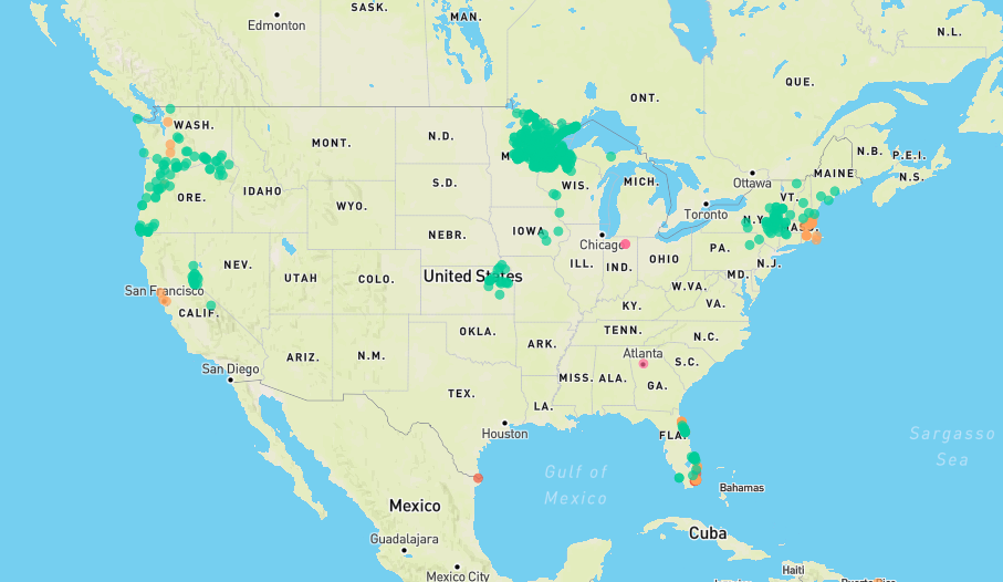
Displays flood and flash flood reports as well as intense rainfall observations for user-selectable time ranges and customizable geographic regions. Includes ability to download reports and associated metadata in csv format.
![GEFS Probs](./para/para_includes/collaboration/gefsprobs.png)
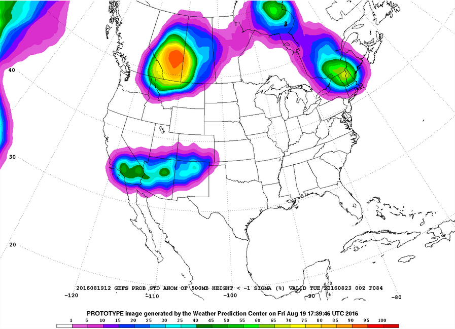
Plots of GEFS probabilistic forecast of precipitation, temperature, and sea-level pressure exceeding various thresholds.
![Local Storm Reports](./para/para_images/lsr.png)
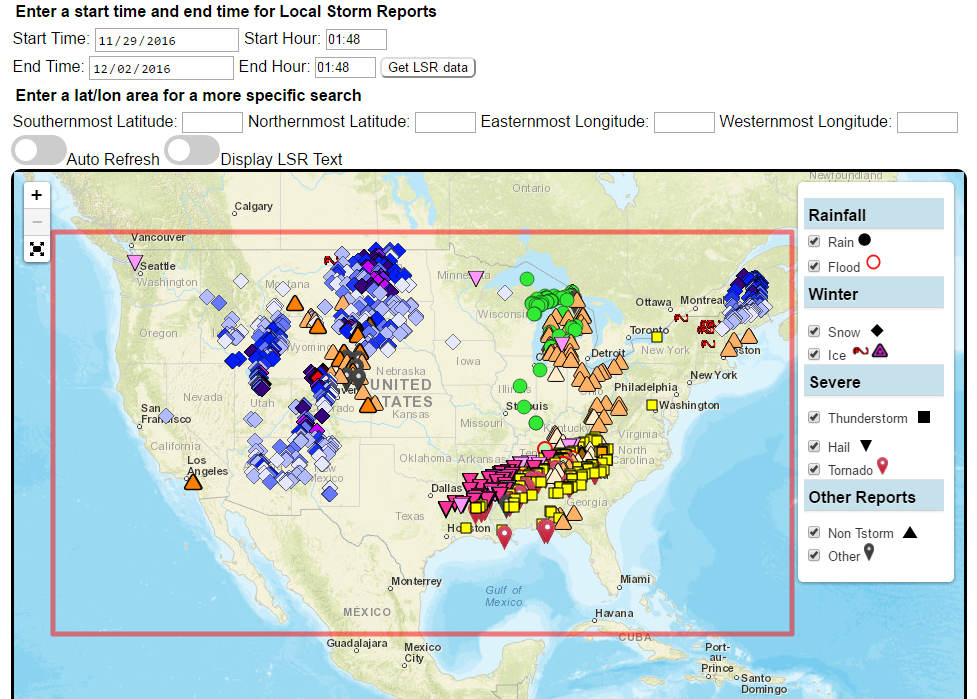
Custom plots of Local Storm Reports across the Contiguous United States. Reports include rain, snow, ice, and severe weather, as well as other significant information from storm spotters.
![Extreme Precipitation Monitor](/para/para_images/epm_exper_staticimage.png)
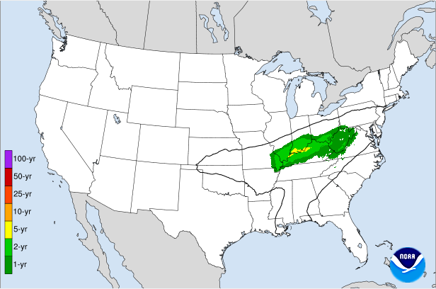
Displays the climatological significance of precipitation forecast by WPC. The climatological significance is represented by Average Recurrence Intervals (ARIs) of precipitation estimates from NOAA Atlas-14 and Atlas2.
![ESAT](./para/para_images/esat.png)
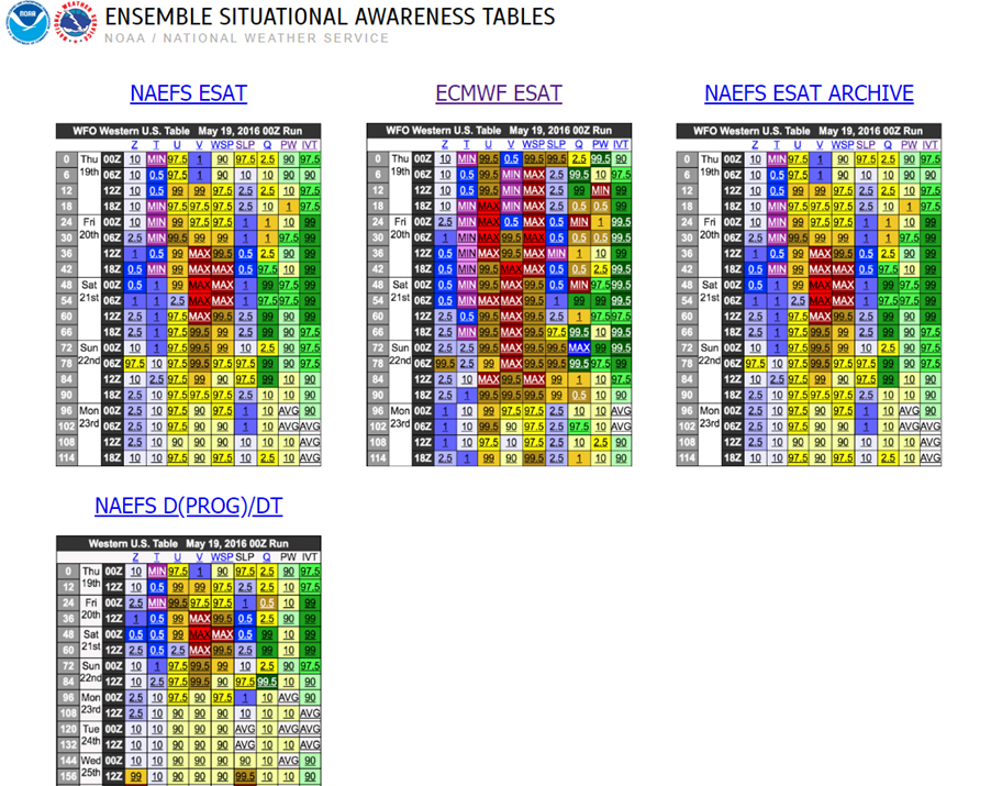
An interactive situational awareness table that displays anomalies, percentiles, and return intervals from the GEFS, NAEFS, and ECMWF Ensembles (login required to view ECMWF data).
*Please note that there is currently an issue where only users on a NOAA network can access this page. We are actively working to resolve this problem.
![NDFD Records](./para/para_images/ndfdrecords_example.png)
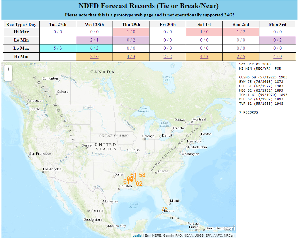
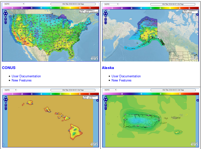
Interactive display of where temperatures could approach or exceed records within the contiguous U.S. (based on NDFD temperature forecasts)
![NWS NDFD Max/Min Temperatures and Departure from Normal](./para/para_images/ndfd_maxmin_departure.gif)
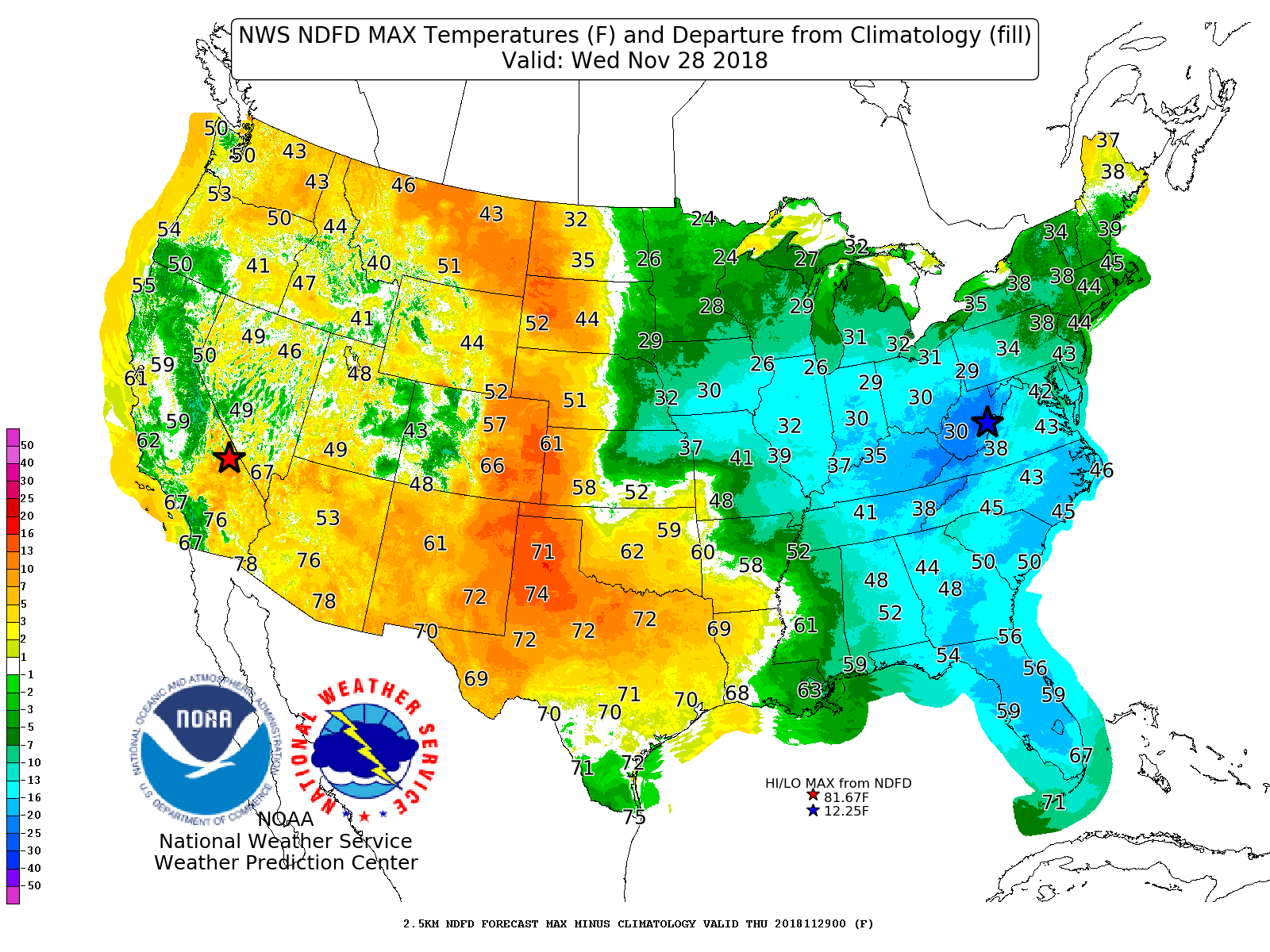
Displays Days 1-7 NDFD maximum and minimum temperatures, along with their respective departures from climatology.
![Prototype Snowband Probability Forecasts](./para/para_images/MTD_example.png)
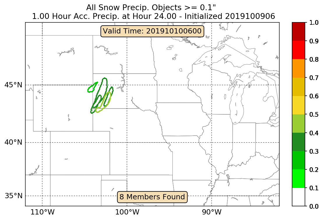
An interactive tool that depicts areas of heavy snowfall from individual members of high-resolution short range ensemble forecasts.
Displays forecast information and its climatological context to quickly alert a forecaster when a record or neear-record breaking event is possible. This tool is available for both CONUS and Alaska.
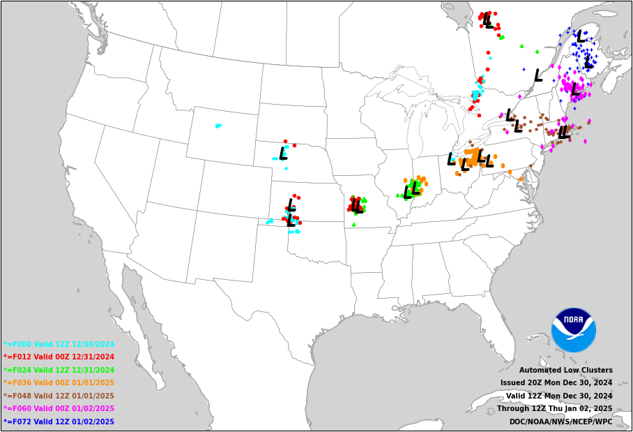
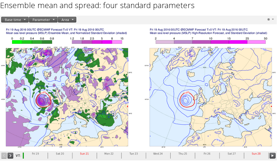
![ERO Map](./para/para_images/TX_Day2.png)
Interface for specialized WPC Excessive Rainfall Outlook Maps for NWS County Warning Areas and States.
![1/3/4/24-hr Changes](./exper/change/tmpf_latest_24_us.gif)
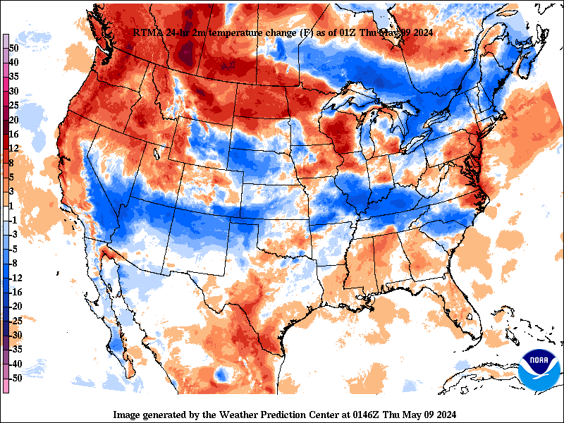
Change in weather parameters (temperature, dewpoint, surface pressure, etc) over the last 1/3/6/24 hours. Data is provided from the Real-Time Mesoscale Analysis (RTMA) or the Rapid Refresh (RAP).
![HeatRisk Map](./para/images/HeatRisk_example.png)
The experimental National Weather Service (NWS) HeatRisk is a color-numeric-based index that provides a forecast of the potential level of risk for heat-related impacts to occur over a 24-hour period, with forecasts available out through 7 days.
![CIPS Guidance](./para/para_includes/collaboration/cips.png)
Analog guidance that uses an objective approach to find historical events that are similar to the upcoming forecast.
![National Blend](./para/para_includes/collaboration/nblend.png)
Nationally consistent and skillful suite of calibrated forecast guidance based on a blend of both NWS and non-NWS numerical weather prediction model data and post-processed model guidance.