


| February 17 2022 |
Rockies to Great Lakes Winter Storm (2/16 - 2/17)
By: Zack Taylor, WPC Meteorologist
Meteorological Overview:
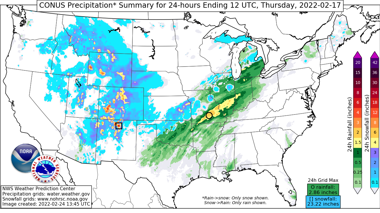
A significant winter storm impacted much of the Intermountain West, central U.S., and Great Lakes February 16-17, 2022, bringing a wide variety of winter weather hazards including heavy snow, sleet, and freezing rain. Leading up to the event, shortwave trough energy dropping through the western U.S. closed off at 500 mb over southern California before swinging through the Four Corners region. It gradually opened up as pieces of the energy began moving into the Southern Plains on the 16th-17th. In the northern stream, shortwave energy dropping through the Canadian Rockies reached the Northern Plains by the 17th and the two systems gradually phased over the Midwest. At the surface, a frontal boundary initially draped from the Great Lakes through the Southern Plains acted as the focus for waves of low pressure to develop along it and track northeast.
As the 500 mb trough axis swung over the Four Corners region, moderate to locally heavy snow blanketed much of the southern to central Rockies. With modest moisture in place combined with upslope flow, snowfall totals on February 16 generally ranged from 6-10" with isolated amounts near a foot.
Once the shortwave ejected out into the southern Plains, low pressure organized over northern Texas and quickly lifted northeast along the frontal boundary draped across the Midwest to Great Lakes. This boundary slipped southward through the day as Arctic high pressure nosed further into the northern Plains. The impressive height falls and forcing for ascent aided by an intensifying 300 mb jet streak over the Great Lakes led to precipitation breaking out early on February 17. A narrow but intense band of snow northwest of the surface low developed and led to a quick burst of snowfall rates 1-2"/hr across portions of southern to eastern Kansas in the morning. This snow band then tracked through the Kansas City metro toward central Illinois and northwest Indiana, largely staying south of the Chicago metro. By the afternoon into the early evening, the heaviest snow reached southern Michigan including the Detroit metro.
Forecast guidance leading up to the event showed above average predictability and agreement in the synoptic pattern. The WPC Winter Weather Outlook highlighted the risk area for impactful winter weather as early as day 7 and the Winter Storm Outlook showed above 50 percent probabilities for significant snowfall accumulations as early as day 3.
Impacts:
As the system moved through the central U.S. and Great Lakes, a narrow swath of heavy snow greater than 4" fell from southern Kansas through southern Michigan, with the greatest snow totals between 6-10" from eastern KS to central Illinois. While Kansas City International Airport's 7.0" total was a daily record for February 17, locations to the south across the metro received up to 10-11" which significantly impacted the morning commute. South of the heavy snow axis, a narrow corridor of freezing rain up to 0.10" occurred with isolated amounts of 0.25" ice accumulation reported in northwest Ohio as well as northern Oklahoma. Aside from the negative impacts from the heavy snow and ice to travel and commerce, the anomalous moisture, preceding heavy rainfall on February 16, and the warm temperatures quickly led to melting snowpack and excessive runoff. This led to flooding and isolated instances of ice jams, particularly for portions of central to northern Illinois.