The Extreme Precipitation Monitor displays the climatological significance of the precipitation forecasted by the Weather Prediction Center (WPC). The climatological significance is represented by Average Recurrence Intervals (ARIs) of precipitation estimates from the NOAA Atlas-14 and NOAA Atlas-2.

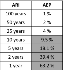
ARIs describe the expected amount of time (e.g., years) between periods of rainfall exceedances (usually in inches) at a given location. For values greater than or equal to 25 years, ARIs are inversely proportional to the Annual Exceedance Probability (AEP), which describes the probability of a particular event occurring at any one location in any given year. For example, precipitation thresholds that have a 100-yr ARI have a 1% AEP (i.e., a 1-in-100 chance of occurring in any given year). The following table shows the equivalent AEP for ARIs ranging from 1-100 years. The Extreme Precipitation Monitor displays exceedances for ARIs between 1 and 100 years and AEPs between 4% and 1%.
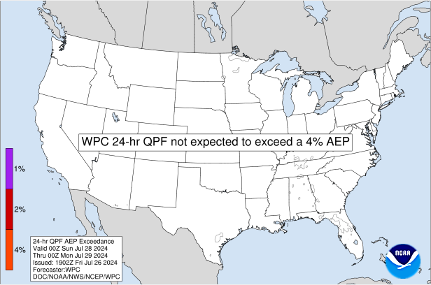
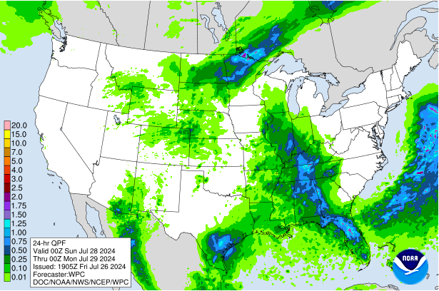
This product is generated with the WPC's Days 1-3 Quantitative Precipitation Forecasts (QPFs) for the 6-, 24-, and 72-hr periods. Users can select from WPC's deterministic or 90th percentile probabilistic QPF for comparison. Each contour level represents an ARI (or AEP) forecasted to be equaled or exceeded for the given time period. The 1" inch contour is included on the imagery with a gray outline for reference to higher QPF amounts. If the QPF for the given period is not expected to exceed the 1-yr ARI (or 4% AEP) anywhere in the domain, the text at the center of the graphic will read "WPC X-hr QPF NOT EXPECTED TO EXCEED THE 1-YR ARI (or 4% AEP)".
These forecast products will be updated four times per day approximately 60-75 minutes after WPC issues its deterministic QPF. See the table below for more specific information.
| Issuance | Approximate Update Time |
| Overnight Preliminary Forecast | 0700 UTC |
| Overnight Final Forecast | 0930 UTC |
| Daytime Preliminary Forecast | 1900 UTC |
| Daytime Final Forecast | 2130 UTC |
The value in recasting the QPF in the context of each ARI is that it allows the user to measure the climatological significance or "rarity" of a forecasted or observed rain event for any location. Furthermore, precipitation ARIs are used in the design of hydrologic and flood-control structures and can be more relatable to emergency managers and key decision makers rather than absolute rain estimates alone. Users should be aware that this product does not consider antecedent conditions and should not be used as a sole indicator for impacts from flooding. The severity of flooding is also dependent on antecedent conditions (soil moisture and soil type), land-use (urban vs. rural), topography, and total areal rainfall coverage.
The NOAA Atlas-14 data is available through the Precipitation Frequency Data Server, which provides point-based estimates of rainfall for ARIs between 1 and 1000 years for rainfall durations ranging from 5-mins up to 60 days based on a 90% confidence interval. Because the NOAA Atlas-14 update has not been completed for the Pacific NW, the NOAA Atlas-2 (1973) is used to supplement this region for the 6-hr and 24-hr duration rainfall comparisons. This data is "stitched" together with the Atlas-14 data (courtesy of Dr. Russ Schumacher - Colorado State University).
For more information on the operational use of this product, please read this article in the National Weather Association Journal of Operational Meteorology.


