| WPC Met Watch |
|
|
Mesoscale Precipitation Discussion: #0172 |
|
(Issued at 634 PM EDT Thu Apr 25 2024
) |
|
| MPD Selection |
|
|
|
|
|

Mesoscale Precipitation Discussion 0172
NWS Weather Prediction Center College Park MD
634 PM EDT Thu Apr 25 2024

Areas affected...Northwest Kansas...Southwest Nebraska...Northeast
Colorado...

Concerning...Heavy rainfall...Flash flooding possible

Valid 252235Z - 260345Z

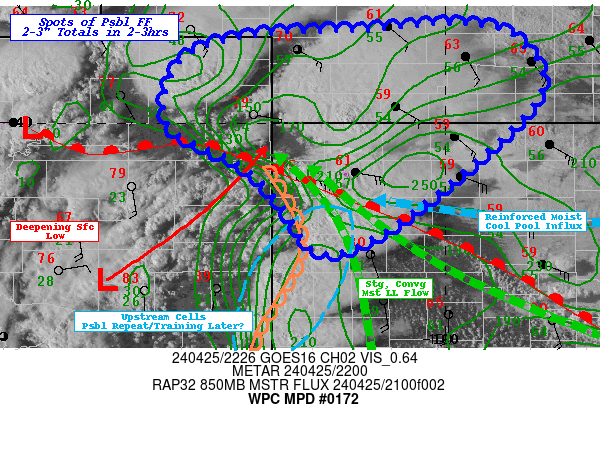
SUMMARY...Increasing moisture flux convergence into convective
clusters within potentially favorable flow regime for
back-building and training rotating cells pose possible localize
flash flooding concerns particularly after 00z this evening.

DISCUSSION...22z surface analysis depicts rapidly deepening
surface low in east-central CO with well defined dry line and warm
fronts extending from a triple point near the Colorado/Kansas
border at the Cheyenne/Sherman county line. The dry line is wavy
extending southward along the state line though appears to be
short-term retreating into southeast Colorado which may provide a
pivotal development region for later training/repeating as they
move northward toward the triple point.  The effective warm sector
is represented by low to mid 80s Temps over lower 60s Tds.
Strong/steep lapse rates via a strong EML above the boundary layer
suggest higher than normal evaporatimve effects especially in the
early stages of development.  However, the very moist low levels
are strongly convergent while also being reinforced along the
north side of the warm front by cooler but still mid to upper 50s
Tds that may entrain into elevated updrafts that meander north of
the frontal zone.  Compound this with strong rotating updrafts
will support localized isallobaric inflow/moisture flux loading
the lower updraft profile with ample moisture to develop heavy
rainfall accompanying hail generation.

GOES-E WV suite also depicts favorable left exit jet ascent for
cell evacuation and potential for cells to grow upscale into
clusters and perhaps a small complex. Cell motions within the
cluster are expected to have a northeast motion at 30-40kts but
stronger rotation, should slow to 20kts per RAP Bunker propagation
vectors.  Additionally, with the approach of shortwave ridging,
backing cell motions toward a more northerly component will
support the potential for repeating/training profiles particularly
after 00z as mid-level drying reduces from earlier evaporation
into the environment.  As such, cells producing 1-1.5"/hr rates
may start to encroach into the 1.5-2"/hr rates.  This presents the
increasing possibility of pockets/scattered clusters of 2-3"
totals in 2-3 hour period.  While the grounds have been dry,
natural FFG values would be in reach of being exceeded in
localized spots given 1hr values of 1.5-2" and 2-2.5/3hrs.  So
while severe threat is currently the primary hazard, the
hydrological risk will be steady increasing through 00z and even a
very strong slow moving high influx  super-cell may induce
localized flash flooding in the short-term.

Gallina

ATTN...WFO...BOU...DDC...GID...GLD...LBF...

ATTN...RFC...ABRFC...MBRFC...NWC...

LAT...LON   41159979 40979916 40289894 38930043 38480142
            39010188 39510237 39990323 40730306 41020220
            41080090
Download in GIS format: Shapefile
| KML
Last Updated: 634 PM EDT Thu Apr 25 2024
|


