|
|
 |
 |
||
 |
| Site Map | News | Organization |
| DOC | NOAA | NWS | NCEP Centers: | AWC | CPC | EMC | NCO | NHC | OPC | SPC | SWPC | WPC |
|
2. Where can I find forecasts beyond 7 days? 3. Where can I find historical or climatological weather data? 4. How can I obtain past forecasts or analyses produced at the WPC? 5. How do I decipher the contractions/abbreviations used in your discussions? 6. How do I interpret the symbols and station model plots on your analysis and 7. For what time is the "current forecast" on your home page valid? 8. Are the 5-day QPF and day 1, 2, and 3 QPFs based on the same guidance? 9. What do the colors represent on your satellite images? 10. Why has the domain for your surface analysis been reduced? 11. Where can I get information about a career in meteorology? 12. Where can I find copies of the Daily Weather Map prior to 2003 online? What is UTC or Z time, and how do I convert it to my local time? UTC literally stands for Universal Time Coordinated (though it is typically referred to as Coordinated Universal Time) and is the standard time common to every place in the world. It is also known as Greenwich Mean Time (GMT) and Zulu (Z). UTC is defined as the time at longitude 0 degrees, the prime meridian. This is the longitudinal line that separates the Eastern and Western Hemispheres, and happens to pass through the Greenwich Observatory outside of London, England. All of our forecast products and the computer models that provide us guidance are based on this universal time zone. When you see 12 UTC or 1200 UTC or 12Z (all are the same and depend on forecaster preference), it refers to noon at Greenwich. 00 UTC or 00Z is midnight Greenwich time. Translating this to your time zone depends on where you live. Below is a table that provides some UTC times and their conversion to the four time zones over the lower 48 for standard time. STANDARD TIME
Where can I find forecasts beyond 7 days? The Climate Prediction Center (CPC) is the branch of NOAA's National Weather Service (NWS) responsible for issuing forecasts beyond 7 days. Their Outlooks page provides links to each of their forecast products, including the 6-10 day and 8-14 day forecasts, along with monthly and seasonal forecasts. Seasonal forecasts are produced in 3-month intervals and extend out to over one year into the future. So, if you are looking for a forecast for the upcoming winter (December-January-February) or summer (June-July-August), simply click on the appropriate link. If you have any questions regarding their forecasts, please click here to e-mail them directly. Where can I find historical or climatological weather data? If you are looking for past weather information for a particular location, you have a couple of options. The first is directly visiting the web site of NOAA's NWS Weather Forecast Office (WFO) that serves the desired location. You can access any of the local offices through the NWS Home Page. If you are not sure which is the correct WFO, type the city or town name in the white box located in the upper left-hand part of their home page and click GO. If you are unable to find information from the local office, the National Climatic Data Center has a very comprehensive collection of data and will likely have whatever you need. You can access them through the link above or call them at 828-271-4800. How can I obtain past forecasts or analyses produced at the WPC? Due to the large number of products issued and limited space, there are only a few products residing on our site that are more than one day old. They are:
We have a link on our site, Explanation of Contractions, that provides definitions for most of the contractions or abbreviations used in our discussions. Included in this list are the two-letter state and territory abbreviations and contractions for the numerical models our forecasters utilize. How do I interpret the symbols and station model plots on your analysis and forecast charts? All of this information can be found by clicking on the links below.
What do the colors represent on your satellite images? The infrared satellite imagery on our web site is "enhanced", which means that the image is modified using a color scheme in order to bring out details in the cloud patterns. The various colors are determined by the amount of energy, translated into temperature, that the satellite is sensing. The image below represents the enhancement curve that is used in all of the satellite imagery on our site. The numbers correspond to the temperature in degrees Celsius that is associated with colors on the enhancement curve. The darker colors on the left side of the represent warmer temperatures, while those to the right are colder. Since the atmosphere cools with height, the areas in yellow, blue, red or green usually indicate progressively higher (therefore colder) cloud tops. The shades of light gray show low cloud tops, while the dark areas on the left side of the curve typically show that the skies are clear and the infrared imagery is actually measuring the temperature of the land or ocean surface. However, infrared images can be misleading in the winter under a very cold air mass. If the surface temperature is, for example, around -25 degrees Celsius (-13 degrees Fahrenheit, not unusual for December-February in the northern U.S. and Canada), the dark yellow image will suggest cloud cover is present even if it is completely clear. In these cases the image needs to be interpreted with caution. 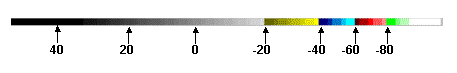
Why has the domain for your surface analysis been reduced? The previous, larger area (covering more of the Atlantic and Pacific Oceans) was defined at time when the North American analysis was distributed by facsimile and only one chart could be sent for each analysis time and this chart needed to meet the needs of a wide variety of users. Most users of NWS products were able to receive only the WPC analysis and it needed to cover a wide area to meet the needs of all users. NCEP now has three centers preparing surface analysis charts over much of the Northern Hemisphere and all are available to all users. The oceanic areas eliminated from the WPC analysis are better served by the Ocean Prediction Center (OPC) and the National Hurricane Center (NHC). Their later deadlines allow more observational data to be incorporated into OPCs' and NHCs' analyses, resulting in a more accurate product. Please see changes to the North American surface analysis for more information. Where can I get information about a career in meteorology? Below are a few links that provide a good introduction into the field of meteorology, including educational requirements and career opportunities.
|
||||||||||||||||||||||||||||||||||||||||||||||||||||||||||||||||||||||||||||||||||||||||||||||||||||||||||||||||||||||||||||||||||