| WPC Met Watch |
|
|
Mesoscale Precipitation Discussion: #1135 (2021) |
|
(Issued at 1046 PM EST Sun Nov 21 2021
) |
|
| MPD Selection |
|
|
|
|
|

Mesoscale Precipitation Discussion 1135
NWS Weather Prediction Center College Park MD
1046 PM EST Sun Nov 21 2021

Areas affected...Deep South Texas...

Concerning...Heavy rainfall...Flash flooding possible

Valid 220345Z - 220900Z

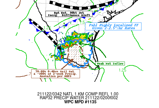
SUMMARY...Intensifying thunderstorms capable of 2-3" totals with
hourly rates near FFG pose low-end possible localized flash
flooding particularly near/along the Rio Grande.

DISCUSSION...03z surface analysis depicts weak southeasterly flow
coming off the Western Gulf of Mexico ahead of southward pushing
cold front between Webb to Live Oak county.  Tds in the upper-60s
to low 70s along with increased moisture in the 85-7H layer (per
CIRA LPW and 00z RAOB at CRP/BRO) support increasing moisture flux
convergence along said boundary to enhanced moisture loading to
the developing updrafts, with total PWats increasing from 1.5 to
about 1.75".  Given strength of convergence along fast moving cold
front, weak 5-10 knot inflow will be increased relative to cell
motions supporting rates of 2-2.5"/hr.

Upper-level support will be steadily supportive of maintaining
updrafts along/ahead of the front as right-entrance of the jet is
exiting across central-coast of Texas, while increasing diffluence
in general.  Forward speed is a limiting factor to extreme
rainfall totals, but localized 2-3" are possible across Deep South
Texas, particularly further west into Starr and W Hidalgo
counties.  This is supported by recent HRRR solutions and 00z ARW,
FV3, Nam-Conest convective allowing models providing increased
confidence to these rates/totals.

Hydrologically, the ground has been abnormally dry across Texas,
with the exception of the area of concern.  2-week anomalies per
AHPS still remain about 300% of normal while NASA LIS 0-40cm
saturation ratios are about 70-80%.  This could result in greater
run-off particularly given the short-duration of 1-2hrs of these
rates, which are in the vicinity of 1hr FFG values (2.5").  As
such, flash flooding is considered possible...however will remain
highly localized in nature and intensity/scope.

Gallina

ATTN...WFO...BRO...

ATTN...RFC...WGRFC...NWC...

LAT...LON   27219826 27199776 26739761 26039812 26339900
            26639930 27029916 27129882
Last Updated: 1046 PM EST Sun Nov 21 2021
|


