| WPC Met Watch |
|
|
Mesoscale Precipitation Discussion: #1050 (2018) |
|
(Issued at 408 AM EST Tue Dec 11 2018
) |
|
| MPD Selection |
|
|
|
|
|

Mesoscale Precipitation Discussion 1050
NWS Weather Prediction Center College Park MD
408 AM EST Tue Dec 11 2018

Areas affected...Western Washington

Concerning...Heavy rainfall

Valid 110908Z - 112108Z

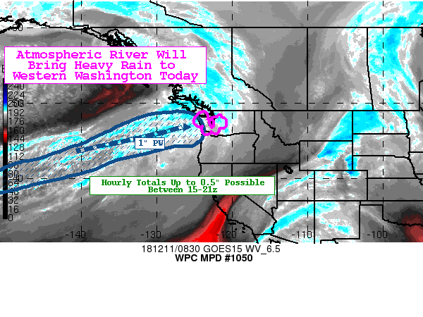
Summary...An atmospheric river will bring widespread moderate to
locally heavy rainfall to the lower elevations of western
Washington today. Through 21z, hourly totals exceeding 0.5" and
total amounts of 2-3" will be possible which could result in
localized runoff and flooding issues.

Discussion...An upper low in the northeastern Gulf of Alaska and
its associated jet streak will bring a plume of enhanced
atmospheric moisture into portions of the Pacific Northwest today.
PWATs reaching or even slightly exceeding 1" will impinge on the
coastal areas with 850 mb flow reaching 50-60 kts by 15z. The
latest RAP shows strong boundary layer convergence as a warm front
lifts into the region. The favorable lift dynamics will lead to
widespread moderate to locally heavy rainfall across the upslope,
steeper terrain areas of the Olympic Mountains and northern
Cascades. By 18-21z, MUCAPE of 100-250 J/kg may push inland (per
latest RAP forecast) which will help drive some of the higher rain
rates up toward 0.5"/hr.

Probabilities of reaching and exceeding 0.5"/hr rates increase
steadily after 15z and persist through at least 21z per latest
hi-res models. The latest run of the HREF show the heaviest rain
to fall from around 14z through 22z with total amounts 2-3" likely
with localized 4-6" amounts possible in the most favored areas.

Antecedent conditions are wet with localized 2-3" amounts falling
in the last 24-36 hours. Snow levels are expected to rise into the
4-5 kft range later today, which will help drive the potential for
runoff and localized flooding issues.

Taylor

ATTN...WFO...PQR...SEW...

ATTN...RFC...NWRFC...

LAT...LON   48872175 48002133 47112164 46182180 45932239
            46432297 46572388 47382416 48052453 48402463
            48032323 47182338 47112338 46762301 47052216
            47982206
Last Updated: 408 AM EST Tue Dec 11 2018
|


