| WPC Met Watch |
|
|
Mesoscale Precipitation Discussion: #0979 (2021) |
|
(Issued at 229 PM EDT Fri Sep 17 2021
) |
|
| MPD Selection |
|
|
|
|
|

Mesoscale Precipitation Discussion 0979
NWS Weather Prediction Center College Park MD
229 PM EDT Fri Sep 17 2021

Areas affected...Southeastern LA...Southern MS/AL...FL
Panhandle...Far Southwest GA

Concerning...Heavy rainfall...Flash flooding possible

Valid 171828Z - 172300Z

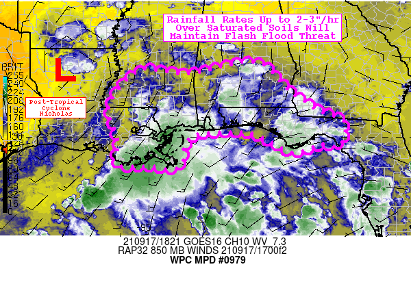
Summary...Scattered convection will occasionally produce rainfall
rates up to 2-3"/hr across portions of the Gulf coast this
afternoon. Given the saturated soils across the area, flash
flooding remains a possibility.

Discussion...Post-tropical Cyclone Nicholas continues to cling to
life, drifting northward over Louisiana. Much of the flash flood
threat this afternoon will continue to be focused to the east and
southeast of the circulation, where low-level flow from the Gulf
of Mexico encounters portions of the Gulf coast. The mesoscale
environment across the region is characterized by PWATs of
1.8-2.2 inches (with as much as 1.1" concentrated below 850 mb),
SB CAPE of 2500-4000 J/kg, and modest effective bulk shear of
15-20 kts. The northward movement of Nicholas (as well as the
ridge axis over the Gulf) has helped to increase low-level flow
(along with the mesoscale influence of the sea breeze), but
moisture transport remains fairly muted despite this. This is
likely because there is already plenty of low-level moisture in
place, but the ragged, weakening circulation of Nicholas is
struggling to significantly organize convective activity/banding.
That said, rainfall rates are occasionally reaching 2-3"/hr given
the overall favorable mesoscale environment for heavy rainfall.

The primary concern for flash flood potential continues to be the
already saturated soils across the region, as NASA SPoRT-LIS 0-40
cm soil moisture anomalies top the 98th percentile for the bulk of
the area. This speaks to the tremendous amount of rainfall that
has fallen as of late, with MRMS 72-hr totals depicting a fairly
large area of 4-8+ inches along coastal MS/AL and surrounding
portions of LA/FL. Localized spots have also seen 2-3" over the
past 6 hours per MRMS, so antecedent conditions are certainly
concerning. All that said, the disorganized nature of the
convection should limit coverage of flash flooding with a distinct
decrease in coverage and intensity anticipated after 23z per the
latest guidance and typical diurnal trends.

Churchill

ATTN...WFO...BMX...JAN...LIX...MOB...TAE...

ATTN...RFC...LMRFC...SERFC...NWC...

LAT...LON   32548637 31628527 30918425 30538336 30108332
            29658354 29778405 29498510 29928595 30168675
            30168777 30048849 29648880 29138886 28908924
            29029001 29019096 29289120 29729100 30709132
            31149130 31799090 32319018 32228945 32168849
Last Updated: 229 PM EDT Fri Sep 17 2021
|


