| WPC Met Watch |
|
|
Mesoscale Precipitation Discussion: #0978 (2021) |
|
(Issued at 1200 PM EDT Fri Sep 17 2021
) |
|
| MPD Selection |
|
|
|
|
|

Mesoscale Precipitation Discussion 0978
NWS Weather Prediction Center College Park MD
1200 PM EDT Fri Sep 17 2021

Areas affected...Northern Louisiana, Eastern Arkansas, far
Southwest Tennessee

Concerning...Heavy rainfall...Flash flooding possible

Valid 171600Z - 172200Z

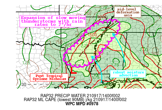
Summary...Showers and thunderstorms will increase through the
afternoon across Louisiana and Arkansas. Rain rates within this
convection may exceed 2"/hr at times, producing 1-3" of rainfall
with locally higher amounts to 5". Flash flooding is possible.

Discussion...GOES-E IR imagery this morning indicates cloud tops
cooling across Louisiana and Arkansas east and north of the center
of Post Tropical Cyclone Nicholas. These cooling cloud tops are
indicative of strengthening convection, which is also evident as
an expansion of reflectivity on the regional radar mosaic and
echoed by an increase in the 15-min lightning density. Recently, a
nearly stationary thunderstorm produced estimated rain rates in
excess of 3"/hr northwest of Shreveport, LA, in response to an
axis of deformation aligned within a ribbon of elevated
instability surging northward from the Gulf of Mexico.

As Post T.C. Nicholas continues to drift slowly northward, its
circulation will increasingly interact with a mid-level trough of
low pressure digging southeast out of Texas. This will intensify
the deformation axis from northern LA into far southwest TN, which
is reflected in recent RAP progs. At the same time, increasing
low-level southerly flow out of the Gulf of Mexico will draw
enhanced PWs of more than 2" measured by the GPS observations, and
MLCape of 1000-1500 J/kg analyzed by the RAP/SPC Mesoanalysis,
northward and into the region. This low-level advection will then
impinge into the axis of deformation to drive locally intense
ascent which should fuel a rapid expansion of convection through
the aftn. This is suggested by many of the available high-res
CAMs, and via HREF probabilities indicating a narrow corridor of
high probabilities for 2"/hr rain rates and greater than 60%
chance for 3"/6hrs. Mean 0-6km wind during this time will be
generally E/SE at 5 kts or less, with propagation vectors becoming
increasingly opposed to the mean wind leading to the potential for
backbuilding and slow moving thunderstorms, within which rain
rates to 2"/hr could produce 1-3" of rainfall with isolated
amounts to 5".

Although rain has been limited the past 14-days noted by AHPS
rainfall that is just 5-25% of normal, 200cm soil moisture is
still above the 90th percentile across parts of northern LA and
southern AR. This indicates that while some absorption of rainfall
into the soils is likely, intense rain rates could still lead to
runoff and flash flooding, and the HREF exceedance probabilities
reach 20-30% despite FFG that is generally 2.5-4"/3hrs. Flash
flooding will be possible through peak heating, and is most likely
where any backbuilding can lengthen the duration of these
excessive rain rates.


Weiss

ATTN...WFO...JAN...LZK...MEG...SHV...

ATTN...RFC...ABRFC...LMRFC...WGRFC...NWC...

LAT...LON   36038984 36038922 35988893 35208906 34728947
            33939013 33299067 32859101 32309160 31949217
            31899283 32069363 32329402 32919396 33839291
            34889200 35479149 35819079
Last Updated: 1200 PM EDT Fri Sep 17 2021
|


