| WPC Met Watch |
|
|
Mesoscale Precipitation Discussion: #0977 (2021) |
|
(Issued at 857 AM EDT Fri Sep 17 2021
) |
|
| MPD Selection |
|
|
|
|
|

Mesoscale Precipitation Discussion 0977
NWS Weather Prediction Center College Park MD
857 AM EDT Fri Sep 17 2021

Areas affected...Central Gulf Coast from Vermilion Bay, LA to the
Apalachee Bay, FL

Concerning...Heavy rainfall...Flash flooding likely

Valid 171256Z - 171830Z

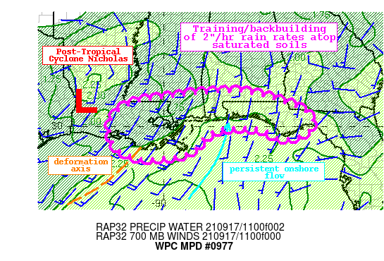
Summary...Showers and thunderstorms developing across the northern
Gulf of Mexico will expand in coverage and lift onshore through
the aftn. Rainfall rates of 2"/hr are likely, which could produce
1-3" of rain with isolated amounts of 5" through training. Flash
flooding is likely.

Discussion...The regional radar mosaic this morning indicates
increasing coverage of showers and thunderstorms across the
northern Gulf of Mexico and coastal portions of the central Gulf
Coast states. This convection is blossoming in a region of
favorable thermodynamics characterized by PWs of 1.75-2.25"
measured on 12Z U/A soundings and MLCape analyzed by the RAP of
1500-2000 J/kg. Although activity is ongoing along the coast with
an isolated flash flood warning already in effect, more concerning
is blossoming activity over the Gulf of Mexico within a plume of
higher PW and along a deformation axis noted in LPW fields between
a ridge of high pressure near the Yucatan Peninsula and a
southward sinking trough over Texas. Here, thunderstorms are
deepening rapidly seen by rapidly cooling cloud tops and an
increase in 15-min lightning density.

As the morning progresses, Post T.C. Nicholas will likely drift
northward, and as the ridge builds from the southern Gulf of
Mexico, onshore flow will gradually increase to 20-25 kts. This
will drive better instability and moisture onshore, and drive an
expansion of convection across the region. Mean 0-6km winds are
forecast to be 10-15 kts from the S/SW, but backbuilding into more
intense instability over the Gulf and along cold pools will cause
upwind propagation vectors to fall to around 5 kts while opposing
the mean wind. This suggests slow movement and training of echoes,
with rainfall rates likely exceeding 2"/hr at times as noted by
HREF probabilities. The combination of intense rain rates and slow
moving or backbuilding cells will produce 1-3" of rainfall with
isolated totals to 5" as shown by many of the available CAMs. The
greatest risk for heavy rainfall should remain near the coast
where instability is greater and enhanced ascent occurs as the
southerly flow is forced upward through convergence along a
coastal trough.

The coverage of this excessive rainfall is not forecast to be
widespread, and there may end up with narrow south-to-north
corridors of heavy rainfall through confluent inflow bands.
However, soil moisture to a depth of 200cm according to NASA SPoRT
is above the 98th percentile due to 14-day rainfall that has been
200-600% of normal. Even without training, rain rates of 2"/hr
could quickly become runoff leading to flash flooding anywhere
within this MPD. However, the greatest threat will be where these
bands train onshore and interact with the coastal front, likely
from near Atchafalaya Bay, LA eastward to the Forgotten Coast of
FL.


Weiss

ATTN...WFO...JAN...LCH...LIX...MOB...TAE...

ATTN...RFC...LMRFC...SERFC...NWC...

LAT...LON   31428693 31378668 31128550 30638426 30298395
            30018396 29738431 29548472 29508522 29798576
            29938612 29968739 29798800 29438848 29128871
            28878923 28719058 28869142 29179197 29849217
            30279210 30639182 30979119 31089045 31238944
            31388815
Last Updated: 857 AM EDT Fri Sep 17 2021
|


