| WPC Met Watch |
|
|
Mesoscale Precipitation Discussion: #0975 (2021) |
|
(Issued at 132 PM EDT Thu Sep 16 2021
) |
|
| MPD Selection |
|
|
|
|
|

Mesoscale Precipitation Discussion 0975
NWS Weather Prediction Center College Park MD
132 PM EDT Thu Sep 16 2021

Areas affected...Mid-Atlantic States from southeast PA to southern
VA

Concerning...Heavy rainfall...Flash flooding possible

Valid 161730Z - 162330Z

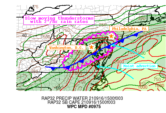
Summary...Thunderstorms developing along a cold front will expand
in coverage and drift slowly across the region through this
evening. Rainfall rates at times could reach 2"/hr, producing 1-3"
of rainfall with locally higher amounts. Flash flooding is
possible.

Discussion...Thunderstorms have begun to develop across eastern VA
and eastern MD along a nearly stationary cold front. The GOES-E
Day Cloud Phase product indicates glaciation is beginning within
the deeper convection, coincident with an increase in lightning
density. These together suggest thunderstorms are intensifying,
and this is also echoed by local radars estimating rain rates that
are now reaching 1.5"/hr near Cambridge, MD. Recent storm motions
across VA and MD have been very slow, generally 5-10 kts as
observed via radar, indicative of the slow and chaotic wind
vectors noted in regional 12Z U/A soundings through 500mb.

Thunderstorms are likely to continue to regenerate along this cold
front through the aftn. PWs as measured by GPS observations are
1.6 to 1.8 inches, well above the 90th percentile at both IAD and
WAL, and these PWs are progged to continue to surge as easterly
flow around Invest 96L pushes onshore. Additionally, modest breaks
in the cloud cover and around the warm Chesapeake Bay waters have
led to a ribbon of robust SBCape analyzed by the RAP to be above
2500 J/kg. Current activity is deepening rapidly within this
overlap of PW and instability, driven by both convergence along
the front and modest diffluence aloft in the tail of a poleward
arcing jet streak lifting into Quebec, Canada.

As heating intensifies the instability through the aftn, it is
likely that thunderstorms will become more widespread and intense.
A lack of meaningful shear should keep the primary storm mode to
pulse, but storm interactions and outflow boundaries may drive
additional development. The HREF 1-hr rainfall probabilities
increase for 2"/hr during the next few hours, and many of the
high-res CAMs depict scattered to numerous pockets of 1-3" of
rainfall. While individual cells may not last very long,
propagation vectors becoming increasingly opposed to the mean
flow, and remaining just 5-10 kts, suggest backbuilding which
could lengthen the temporal duration of heavy rainfall in some
areas. This is reflected by HREF probabilities for 3-hr rainfall
which reach 20-30% for 3 hours, highest along and east of the I-95
corridor, including Washington, D.C.

The past 7-days have been locally dry as evidenced by AHPS
rainfall that is just 10-25% of normal, leading to FFG that is
generally 2-2.5"/1hr and 2.5-4"/3hrs. However, these does exist
some locally lower FFG west of the Fall Line and within the urban
corridor, and HREF exceedance probabilities climb towards 30% this
evening. Flash flooding is possible, but will be most likely
within the I-95 urban corridor or where any storm can
linger/backbuild atop the more saturated soils.


Weiss

ATTN...WFO...AKQ...CTP...LWX...PHI...RNK...

ATTN...RFC...MARFC...SERFC...NWC...

LAT...LON   40167552 40167503 40047475 39847470 39517475
            39217488 39087503 38557550 38337578 38047639
            37607728 37247797 36967881 36977925 37247955
            37717947 38077903 38627845 39187787 39617729
            39877672 40067611
Last Updated: 132 PM EDT Thu Sep 16 2021
|


