| WPC Met Watch |
|
|
Mesoscale Precipitation Discussion: #0974 (2021) |
|
(Issued at 341 AM EDT Thu Sep 16 2021
) |
|
| MPD Selection |
|
|
|
|
|

Mesoscale Precipitation Discussion 0974
NWS Weather Prediction Center College Park MD
341 AM EDT Thu Sep 16 2021

Areas affected...Central Gulf Coast

Concerning...Heavy rainfall...Flash flooding possible

Valid 160740Z - 161330Z

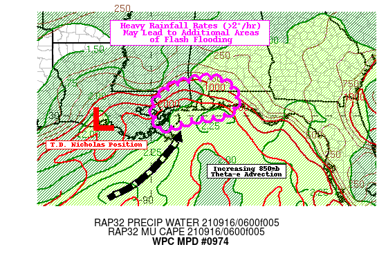
SUMMARY...Showers and thunderstorms containing rich tropical
moisture are likely to produce heavy rainfall rates that could
lead to areas of flash flooding this morning.

DISCUSSION...Tropical Depression Nicholas continues to gradually
weaken over south-central Louisiana but it maintains a deep fetch
of tropical moisture aimed directly at the central Gulf Coast.
Doppler Radar shows scattered convection at this time with
rainfall rates over 1"/hr and potentially reaching as high as
2"/hr. Rainfall rates are likely to pick up slightly, however, as
short term RAP forecasts show a push of moisture streaming out
from a rich reservoir of 850mb theta-e air arriving from the
southwest later this morning. This environment over the north
central Gulf of Mexico contains PWs in excess of 2.25" and rising
MUCAPE levels over 2,000 J/kg that eventually reach the coastal
areas.

Latest 00Z HREF probabilities key in on an area from southern
Mississippi to far northwest Florida between 07-09Z, then
extending towards the coast of the Florida Panhandle after 09Z.
The latest 06Z HRRR is also indicating another round of heavy
showers and storms around the Mobile area just before 12Z. Some of
this activity could be identified by developing convection south
of the AL/MS border tracking north-northeast towards the Alabama
coast. These cells and any developing convection along the coast
could produce rainfall rates in excess of 2" per hour. Rates may
not be quite as intense compared to when Nicholas was in its
prime, but FFG is low enough (especially in and around the Mobile
area where 3-hr FFG is as low as 2") to potentially trigger areas
of flash flooding. Some additional convection with locally
excessive rainfall rates may also redevelop over far eastern
Louisiana between 10-13Z.

Mullinax

ATTN...WFO...JAN...LIX...MOB...

ATTN...RFC...LMRFC...SERFC...NWC...

LAT...LON   31528759 31288686 30758646 30118684 29878839
            29478950 29958979 30568981 31058929 31378850
Last Updated: 341 AM EDT Thu Sep 16 2021
|


