| WPC Met Watch |
|
|
Mesoscale Precipitation Discussion: #0971 (2018) |
|
(Issued at 423 AM EDT Fri Oct 12 2018
) |
|
| MPD Selection |
|
|
|
|
|

Mesoscale Precipitation Discussion 0971
NWS Weather Prediction Center College Park MD
423 AM EDT Fri Oct 12 2018

Areas affected...New Jersey to Long Island and Southern New
England

Concerning...Heavy rainfall...Flash flooding likely

Valid 120822Z - 121400Z

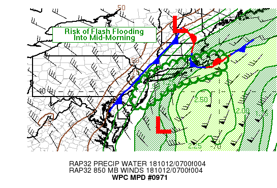
Summary...Rain bands on the northern periphery of what had been
Tropical Storm Michael will continue to spread north across Long
Island into southern New England throughout the morning.  Rainfall
over much of New Jersey early this morning will gradually be
tapering off after sunrise as the storm pulls away

Discussion...Coverage of heavy to potentially excessive rainfall
will continue to expand over Long Island and spread into southern
New England throughout the morning as the center of low passes
south of the area.  In addition to tropical moisture being drawn
into the area by the low pressure center, the approach of a cold
front from the west may also help to focus and enhance rainfall
amounts.

Maximum rainfall rates of 1 to 2 inches per hour are expected in
the most intense bands, with rainfall totals generally in the  1
to 3 inches across Long Island into southern New England.
Rainfall amounts across Martha's Vineyard and Nantucket are
expected to be in the 3 to 5 inch range.  Locally higher amounts
are possible throughout the region in the event that any of the
rain bands stall or pivot.

Flash flooding is likely within this area given the rainfall rates
expected.  Urbanized areas will be most prone to the flood threat.

Farther east, additional rainfall amounts of 1 to 2 inches are
expected over New Jersey before rainfall rates begin to taper off
as the storm moves away.

Bann

ATTN...WFO...BOX...OKX...PHI...

ATTN...RFC...MARFC...NERFC...

LAT...LON   42156985 41566970 41216993 40877073 40437244
            39287411 39207482 40257455 40907394 41547254
            41967084
Last Updated: 423 AM EDT Fri Oct 12 2018
|


