| WPC Met Watch |
|
|
Mesoscale Precipitation Discussion: #0967 (2021) |
|
(Issued at 801 PM EDT Tue Sep 14 2021
) |
|
| MPD Selection |
|
|
|
|
|

Mesoscale Precipitation Discussion 0967
NWS Weather Prediction Center College Park MD
801 PM EDT Tue Sep 14 2021

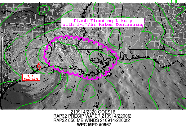
Areas affected...Much of Louisiana...Far Southern Mississippi

Concerning...Heavy rainfall...Flash flooding likely

Valid 150000Z - 150600Z

Summary...Periods of heavy rainfall (1-3"/hr rates) will continue
in association with slow-moving Tropical Storm Nicholas. Flash
flooding is likely.

Discussion...Tropical Storm Nicholas has slowly meandered east
over the course of the day, effectively marking an end to heavy
rainfall threat across Southeast Texas. With the center of
circulation now nearing the Texas/Louisiana border, the best
thermodynamic forcing (isentropic upglide and low-level moisture
transport) will continue to favor the eastern half of Nicholas'
circulation. While it is difficult to pin down the exact spatial
extent of the heavy rainfall threat, continued deep moisture
convergence will occasionally result in more organized inflow
banding with the potential for training/repeating of 1-3"/hr
rainfall rates. These highly efficient rates will be sustained by
PWATs of 2.1 to 2.4 inches and SB CAPE of 500-1500 J/kg (per
aforementioned persistent latent heat flux from the Gulf).

Perhaps the more concerning aspect of the flash flood potential
(and the primary reason for 'likely' wording) is due to the
prolonged nature of the event with 2-4 inches of rainfall having
already occurred over the past 12 hours over much of southern LA.
This rainfall has already lowered flash flood guidance (FFG) to
below 2" locally, and 3-hr FFG of 3" or less is fairly widespread
across the highlighted area. Rainfall rates of 1-3"/hr may reach
or exceed these FFG all on their own, but repeating/training of
rain bands and/or unfortunate placement near vulnerable areas
(i.e. urban metro locations) will act to further increase the
flash flood threat. Given the favorable tropical mesoscale
environment for heavy rainfall, the slow forward motion of
Nicholas, and the aforementioned antecedent conditions, flash
flooding is considered likely.

Churchill

ATTN...WFO...JAN...LCH...LIX...MOB...SHV...

ATTN...RFC...LMRFC...WGRFC...NWC...

LAT...LON   31829295 31719126 31298994 30548869 30218868
            29638925 29238964 28879055 29259160 29429246
            29769335 30179379 30509399 31179370
Last Updated: 801 PM EDT Tue Sep 14 2021
|


