| WPC Met Watch |
|
|
Mesoscale Precipitation Discussion: #0906 (2018) |
|
(Issued at 457 AM EDT Fri Sep 28 2018
) |
|
| MPD Selection |
|
|
|
|
|

Mesoscale Precipitation Discussion 906
NWS Weather Prediction Center College Park MD
457 AM EDT Fri Sep 28 2018

Areas affected...Southern New England

Concerning...Heavy rainfall...Flash flooding possible

Valid 280855Z - 281455Z

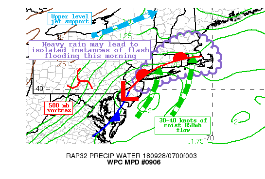
Summary...Widespread moderate rain with numerous embedded
convective cells is expected across southern New England through
the mid-morning hours.  Wet antecedent conditions increases the
concern for flooding issues and enhanced run-off.

Discussion...Regional Doppler radar imagery indicates a widespread
area of moderate to heavy rain progressing from southwest to
northeast and approaching the greater New York City area as of 5
am local time. Embedded convection is also present and these cells
are producing rainfall rates in excess of an inch per hour at
times.  This activity will be making its way across Long Island
and then Connecticut and Rhode Island through 8 am.  Moderate to
heavy rain may persist across parts of central and eastern
Massachusetts before exiting the coast by 11 am local time.

The latest surface analysis depicts a wave of low pressure
situated along a coastal front near the New Jersey Coast.  Large
scale ascent is being aided by a shortwave trough approaching from
Pennsylvania and right entrance upper level jet dynamics in place.
 Anomalous levels of moisture are also in place with PWs on the
order of 1.5 to 2 inches near the coast.

Recent high res model runs are indicating the potential for swaths
of 1 to locally 2 inches of rain by 11 am local time, with the
greatest amounts likely for Long Island and coastal Connecticut.
Many areas across southern New England have received heavy rain
over the past few days, and this increases the susceptibility to
enhanced run-off and possible flash flooding, especially for more
urban areas.

D. Hamrick

ATTN...WFO...ALY...BOX...GYX...OKX...PHI...

ATTN...RFC...MARFC...NERFC...

LAT...LON   43247115 43117070 42887034 42457002 42086968
            41496963 41146985 41037052 40947143 40717231
            40387316 40037376 39987419 40217449 40827434
            41377387 41997340 42527278 43087190
Last Updated: 457 AM EDT Fri Sep 28 2018
|


