| WPC Met Watch |
|
|
Mesoscale Precipitation Discussion: #0868 (2018) |
|
(Issued at 112 AM EDT Thu Sep 20 2018
) |
|
| MPD Selection |
|
|
|
|
|

Mesoscale Precipitation Discussion 0868
NWS Weather Prediction Center College Park MD
112 AM EDT Thu Sep 20 2018

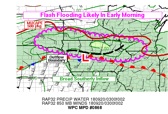
Areas affected...SE SD, Far S MN, N IA, SW WI, Far NW IL

Concerning...Heavy rainfall...Flash flooding likely

Valid 200511Z - 201100Z

Summary...Widespread rain is expected across the Upper Midwest
early this morning, with embedded thunderstorms. Areas that
experience slow-moving or persistent thunderstorms are likely to
experience flash flooding. Rainfall of 2-3 inches will be possible
in 3 hours or less in the heaviest rain bands.

Discussion...GOES-16 IR satellite channels show a broad area of
cold cloud tops below -50C extending from South Dakota into
Wisconsin, a distance along the long axis of over 500 miles.
Regional radars show widespread light to moderate rain over the
same area, with embedded convective banding and thunderstorms.
Lightning activity has decreased somewhat between 03Z and 05Z, but
some embedded thunderstorms are still present. The convective
bands are being sustained and enhanced in a region of 900-700mb
frontogenesis to the north of a surface front from far
southeastern South Dakota into northern Iowa. The potential for
convective rain bands with heavy rain rates appears to be
increasingly restricted into a narrow west-east corridor over the
region. From the north, stable air is being reinforced by steady
northeast winds over much of Minnesota and adjacent portions of
the Dakotas and Wisconsin. The 60 degree isotherm at the surface
has been suppressed nearly to the IA-MN border. From the south,
mid-level dry air should continue to restrict the southward extent
of heavy rainfall. The dry air shows up prominently on the GOES-16
Channel 10 (low-level water vapor), and is confirmed by a very dry
500-300mb layer on the 00Z OAX sounding.

Therefore, convective rain will have a narrow corridor north of
the surface front during the early morning hours. MUCAPE ranging
from around 500 j/kg in southern Minnesota, to 1500 j/kg in
central Iowa, should support continued convection and elevated
thunderstorms given the relatively strong frontogenesis aloft on
the nose of a broad SSW low-level jet. Convection will also have
the potential to train repeatedly over similar areas given the
general west-to-east motion already observed on radar, and the
similar orientation of the favorable zone for heavy rainfall. The
00Z HREF shows relatively high probabilities (over 50 percent) of
exceeding 3hr FFG near the MN-IA border, although it and the
individual component hi-res models seem to generally be too far
north with their heavy QPF axis over the next several hours.
Nevertheless, FFG is fairly similar over most of the region, so
even a small southward displacement of the heavy rainfall
shouldn't make a significant difference in the FFG exceedance
probabilities. Therefore, some additional areas of flooding appear
likely during the remainder of the early morning hours. Although
hourly rain rates may not be exceptionally high, 0.5 to 1.5 in/hr
rain rates sustained over a few hours should be sufficient to
produce swaths of 2-3 inches in a few hours; that should be
sufficient to produce flooding given 3hr FFG generally around 2
inches.

Lamers

ATTN...WFO...ARX...DMX...DVN...FSD...LOT...MKX...MPX...OAX...

ATTN...RFC...MBRFC...NCRFC...

LAT...LON   44489615 43929346 43689080 43238915 42478890
            41789027 41839283 42029413 42229563 42529677
            42689776 43319903 44249810
Last Updated: 112 AM EDT Thu Sep 20 2018
|


