| WPC Met Watch |
|
|
Mesoscale Precipitation Discussion: #0706 (2018) |
|
(Issued at 200 PM EDT Tue Aug 21 2018
) |
|
| MPD Selection |
|
|
|
|
|

Mesoscale Precipitation Discussion 0706...Corrected
NWS Weather Prediction Center College Park MD
200 PM EDT Tue Aug 21 2018

Corrected for TYPO

Areas affected...Northern AZ...Southern UT

Concerning...Heavy rainfall...Flash flooding possible

Valid 211730Z - 212330Z

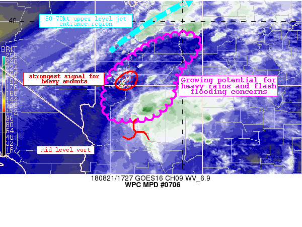
Summary...Deepening moisture along with daytime heating and
favorable forcing are expected to support increasing shower and
thunderstorm coverage, with the potential for heavy amounts and
flash flooding concerns.

Discussion...An MCV lifting north across Arizona, along with
right-entrance region upper jet forcing, is expected to support an
expanding area of showers and thunderstorms, while increasing
moisture raises the potential for heavy rainfall rates and
flash-flooding concerns.  Ridging centered over the southern
Plains, along with an upstream trough over the Northwest will
continue to support an enhanced corridor of southerly to
southwesterly flow -- channeling anomalous moisture across the
highlighted region.  Mesoanalysis shows moisture continuing to
increase through the late morning, with the latest analysis
showing PWs of 0.9-1.2 within much of the highlighted region.
Meanwhile recent runs of the RAP show a further increase as the
afternoon progresses.  Several 12 UTC hi-res guidance models show
a strong signal for heavy rains ahead of the previously noted MCV
as it approaches the Arizona/Utah border this afternoon.  The
strongest signal is centered near eastern portions of Zion
National Park and over western sections of Kane County, UT and
western portions of Bryce Canyon National Park.  For the 6-hr
period ending at 00 UTC Wed, 40km neighborhood probabilities from
the 12 UTC HREF Mean exceed 90 percent for amounts of an inch or
more and are greater than 50 percent for amounts of 2-inches or
more.

Pereira

ATTN...WFO...FGZ...GJT...SLC...VEF...

ATTN...RFC...CBRFC...

LAT...LON   39361000 39130924 38500946 37661024 36461051
            35701126 35491196 35481304 35601341 36251361
            37471329 38381224 39011123
Last Updated: 200 PM EDT Tue Aug 21 2018
|


