| WPC Met Watch |
|
|
Mesoscale Precipitation Discussion: #0677 (2018) |
|
(Issued at 712 PM EDT Thu Aug 16 2018
) |
|
| MPD Selection |
|
|
|
|
|

Mesoscale Precipitation Discussion 0677
NWS Weather Prediction Center College Park MD
712 PM EDT Thu Aug 16 2018

Areas affected...Southeast KS...Central/Eastern OK...Southwest
MO...Northwest AR

Concerning...Heavy rainfall...Flash flooding likely

Valid 162310Z - 170345Z

Summary...Heavy showers and thunderstorms will continue to
organize through the evening hours. Flash flooding will remain
likely.

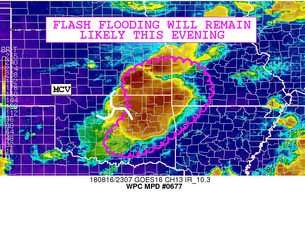
Discussion...The latest GOES-16 10.3 micron/clean IR satellite
imagery shows an impressively cold-topped MCS evolving across
northeast OK and also expanding into adjacent areas of southeast
KS in conjunction with a well-defined MCV that is advancing off to
the east. The convection is producing a well-defined cold pool
which is facilitating a radial downwind propagation. The
convection though is encountering a very unstable airmass in
particular over southeast KS where MLCAPE values are as much 4000
j/kg. Meanwhile, the airmass over eastern OK by comparison is a
little more stable with MLCAPE values of as much as 2500 to 3000
j/kg.

The convection going through the evening hours will likely become
a bit more concentrated over southeast KS and southwest MO as
additional convective development farther north over east-central
KS drops down to the southeast and supports the idea of some
cell-mergers with the activity lifting northeast out of northeast
OK. This will likely support a new MCS evolution over the next few
hours as the convection also interacts with such strong
instability. There is an axis of modest deep layer ascent over
this region too that is being fostered by weak right-entrance
region jet dynamics which is being facilitated by the upper low
farther north over central IA. Meanwhile, the convective threat
over eastern OK and far northwest AR is more contingent on the
ability of the cold pool to generate new convection along the
leading edge of the outflow.

PWATS as per the latest GPS-derived data remain on the order of
1.8 to 2.0 inches and this will support highly efficient rainfall
processes for enhanced rainfall rates that could approach 2.5
inches/hr. This will especially be the case within areas of
overshooting tops.

The expectation at this point is that areas of southeast KS and
southwest MO in particular may see as much as 3 to 5+ inches of
rain through 03Z with impacts on areas that have seen heavy
rainfall recently. Areas farther south over central/eastern OK and
possibly northwest AR will need to be closely monitored, but there
will be the potential for an additional 2 to 4+ inches of rain
here as upstream convection evolves. Flash flooding will be
likely, which includes ongoing activity over central/eastern OK
and but also the anticipated rainfall over southeast KS and
southwest MO.

Orrison

ATTN...WFO...EAX...ICT...LZK...OUN...SGF...TOP...TSA...

ATTN...RFC...ABRFC...LMRFC...MBRFC...

LAT...LON   38569446 38209334 37429290 36629308 35519423
            34629552 34349655 34419730 34639757 35059756
            35859685 36189657 36539649 36959653 37659680
            38359594
Last Updated: 712 PM EDT Thu Aug 16 2018
|


