| WPC Met Watch |
|
|
Mesoscale Precipitation Discussion: #0443 (2019) |
|
(Issued at 1131 PM EDT Mon Jun 17 2019
) |
|
| MPD Selection |
|
|
|
|
|

Mesoscale Precipitation Discussion 0443
NWS Weather Prediction Center College Park MD
1131 PM EDT Mon Jun 17 2019

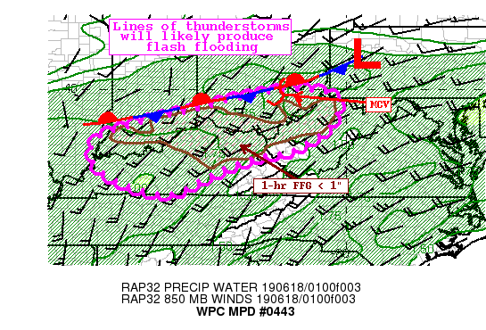
Areas affected...Southern IN, Southern OH, Western WV, Much of KY

Concerning...Heavy rainfall...Flash flooding likely

Valid 180330Z - 180900Z

Summary...A line of thunderstorms developing south of a stationary
boundary will lift east-northeast. Training of cells with heavy
rainfall rates of 1"/hr or greater are likely. This rainfall
occurring on top of extremely saturated soils and very low FFG
will quickly lead to flash flooding.

Discussion...An MCV evident on regional radar mosaic lifting
through central OH is trailing a line of increasing convection
southwestward to western KY. This convection is developing in an
environment characterized by anomalously high PWAT of 1.6-1.8
inches on local 00Z U/A soundings, with MUCape still 500-1000
J/kg. Initially, layer Corfidi vectors are positioned just right
of the mean 0-6km flow suggesting some backbuilding is possible as
the boundary shifts northeast, but will transition to become more
parallel to the flow and the boundary, at which time training will
become more prevalent.

Rainfall rates have been estimated to exceed 1"/hr on latest KJKL
WSR-88D in the favorable environment. Periodic rain rates of this
intensity are likely to continue for the next few hours before the
instability is exhausted, and this is echoed by recent HREF
neighborhood probabilities for 1"/hr rainfall. 0-6km mean wind is
relatively high, 20-30 kts, which will limit the duration of these
rain rates over any given area. However, as the 850mb LLJ becomes
more aligned with the mean flow driving increasingly
unidirectional shear, training of these echoes could produce 1-2"
of rainfall with locally higher amounts.

This area has received significant rainfall recently, with MRMS
24-hr rainfall depicting widespread 1-2", with locally more, and
7-day rainfall has been as much as 600% of normal. Local FFG is as
low as 0.75"/1hr or 1"/3hr, so even brief intense rainfall would
lead to runoff and flash flooding. Areas that receive training and
more significant rainfall accumulation could experience
potentially significant flash flooding.

Weiss

ATTN...WFO...ILN...ILX...IND...JKL...LMK...PAH...PBZ...RLX...

ATTN...RFC...OHRFC...

LAT...LON   39968185 39968141 39938100 39888073 39848050
            39708032 39558023 39048037 38788060 38528091
            38378116 38218151 38128163 38008210 37938243
            37878275 37708327 37658350 37418404 37058479
            36798529 36678577 36738638 36898688 37108740
            37378787 37678810 38178817 38558780 38708732
            38898667 39078591 39248520 39448438 39658367
            39778296 39898234
Last Updated: 1131 PM EDT Mon Jun 17 2019
|


