| WPC Met Watch |
|
|
Mesoscale Precipitation Discussion: #0427 (2019) |
|
(Issued at 427 AM EDT Sun Jun 16 2019
) |
|
| MPD Selection |
|
|
|
|
|

Mesoscale Precipitation Discussion 0427...Corrected
NWS Weather Prediction Center College Park MD
427 AM EDT Sun Jun 16 2019

Corrected for Fixed wording in headline

Areas affected...East-Central IL, Southern IN, Southern OH,
Western WV

Concerning...Heavy rainfall...Flash flooding possible

Valid 160815Z - 161415Z

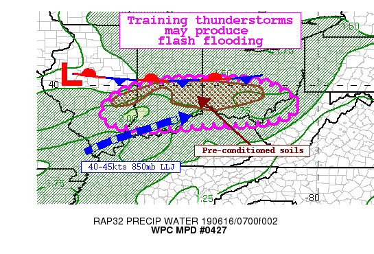
Summary...Thunderstorms along a stationary boundary will increase
in coverage as a shortwave impulse moves overhead. Cells will move
west to east and train across areas that have already received
heavy rainfall this morning. An additional 1-2" of rainfall, with
locally higher amounts, may renew flash flooding.

Discussion...A shortwave responsible for an MCS moving quickly
through IL this morning will continue to push east into IN and OH
over the next several hours. This forcing will interact with a
west-to-east oriented stationary boundary stalled across central
IN/OH to enhance ascent and increase thunderstorm coverage.
Despite widespread convection earlier which produced locally 2-3"
of rainfall, the environment remains favorable for convection with
heavy rainfall. A SW 850mb LLJ is measured on regional VWPs of
40-45 kts, which is advecting anomalously high PWAT of 1.5-1.7
inches, 1.5 standard deviations above the climatological mean,
into the region. Additionally, MUCape south of the boundary
remains elevated, 500-1500 J/kg, suggesting instability remains
despite antecedent convection.

As the shortwave drives eastward, it will enhance ongoing
convection, and high-res CAMs depict increasing coverage of
thunderstorms. As the LLJ slowly becomes increasingly pointed to
the east, shear vectors become unidirectional and parallel to the
boundary. This will likely lead to training of echoes embedded
within convective clusters organized through bulk shear of 25-35
kts. Despite the 0-6km mean wind forecast to reach 40 kts, flash
flooding is likely due to training, especially across
pre-conditioned soils where HRRR 1cm saturation is above 80%. HREF
neighborhood probabilities for 1"/hr rainfall rates are 60% or
more, with some potential for rates up to 2"/hr, and rainfall
totals may exceed 3" in some places. This rain falling on top of
saturated soils with low FFG will quickly lead to runoff and
potential flash flooding as evidenced by HREF exceedance
probabilities as high as 60% for 3-hrs.

Although the high-res guidance agrees on increasing coverage of
convection and heavy rainfall, discrepancies exist in placement,
likely due to the wavering of the boundary in response to the
motion of the shortwave. Flash flooding is possible due to
training of heavy rain rates, but if the heaviest swath sets up
across the same areas already impacted today (mainly E-W oriented
in the vicinity of CVG) then flash flooding would become likely.

Weiss

ATTN...WFO...ILN...ILX...IND...JKL...LMK...LSX...PAH...PBZ...
RLX...

ATTN...RFC...NCRFC...OHRFC...

LAT...LON   40208406 40208317 40058226 39938188 39518114
            39248091 38898106 38578189 38438304 38428434
            38368486 38268627 38238671 38228709 38258751
            38298792 38378838 38488875 38628887 38758895
            39068887 39208876 39398855 39548835 39668808
            39778785 39888757 39968729 40008711 40018702
            40178602 40198506
Last Updated: 427 AM EDT Sun Jun 16 2019
|


