| WPC Met Watch |
|
|
Mesoscale Precipitation Discussion: #0286 (2019) |
|
(Issued at 657 PM EDT Fri May 24 2019
) |
|
| MPD Selection |
|
|
|
|
|

Mesoscale Precipitation Discussion 0286
NWS Weather Prediction Center College Park MD
657 PM EDT Fri May 24 2019

Areas affected...Southwest through North Central Oklahoma

Concerning...Heavy rainfall...Flash flooding likely

Valid 242256Z - 250356Z

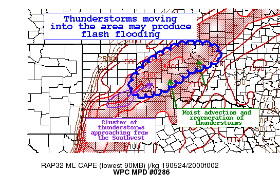
Summary...Clusters of thunderstorms moving northeast ahead of a
cold front will lift slowly across the discussion area this
evening. The combination of intense instability and enhanced
column moisture will make these thunderstorms torrential rain
producers, and flash flooding is possible.

Discussion...Thunderstorms ahead of a cold front continue to
expand in coverage in response to an impressive thermodynamic
environment and modest synoptic ascent. One cluster of these
thunderstorms across Western North Texas is growing upscale in an
environment characterized by 40-50 kts of bulk shear. At the same
time, backbuilding of persists on the SW flank of this cluster,
and recent high-res guidance suggests this will continue to lift
northeast and expand into the discussion area this evening.

Estimated rainfall rates from the KLBB WSR-88D have reached as
high as 2-2.5"/hr, which is double the 1-hr FFG, and even exceeds
the 3-hr FFG in some places as well. While some uncertainty
remains into how this cluster will evolve as it lifts
east-northeastward, the thermodynamic environment across Oklahoma
remains extreme this evening with RAP MLCape approaching 3000 J/kg
and PWATs of over 1.9 inches as sampled by the 18Z KLMN upper air
sounding. As the LLJ begins to strengthen from the south this
evening, it will intensify the moist advection, and the
expectation is that this storm cluster will survive several hours
as it travels towards central Oklahoma. At the same time,
a weak secondary jet max lifting northeast into Kansas should pair
with a subtle shortwave evident on water vapor imagery to develop
and enhance other convection across the area. These additional
storms may lift initially to the north tied to the southerly LLJ,
producing storm mergers and likely enhancing the rainfall
potential locally.

Latest HRRR and NAMNest simulated reflectivity suggests cold pool
processes will begin to develop and push the thunderstorms more
eastward, but this has been overdone through today, likely due to
relatively modest synoptic ascent. Instead, expect primarily SW to
NE motion, except in the strongest cells which may exhibit more of
an eastward trajectory. Extreme SW Oklahoma has been relatively
dry the past 7-14 days, but these intense rain rates, especially
where training can occur, will produce the potential for flash
flooding. Further north into central and northern Oklahoma, recent
rainfall departures have exceeded 300% of normal, so even moderate
rain producers will likely lead to flash flooding across these
areas.

Weiss

ATTN...WFO...AMA...ICT...LUB...OUN...TSA...

ATTN...RFC...ABRFC...

LAT...LON   37019708 37009659 36979618 36909588 36739558
            36519545 36209548 36019586 35859622 35689671
            35549718 35229746 34909792 34679826 34509854
            34379889 34299918 34249946 34239978 34230000
            34320015 34470023 34710029 35020019 35439989
            35799958 36129910 36309886 36539841 36789800
            36909769 36979744
Last Updated: 657 PM EDT Fri May 24 2019
|


