| WPC Met Watch |
|
|
Mesoscale Precipitation Discussion: #0240 |
|
(Issued at 152 PM EDT Wed May 08 2024
) |
|
| MPD Selection |
|
|
|
|
|

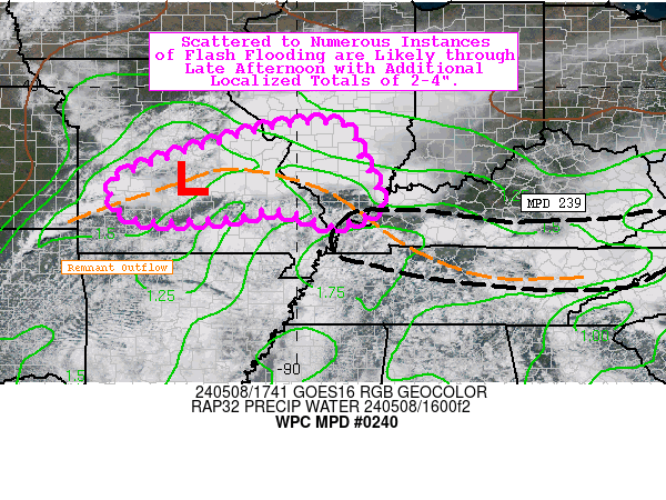
Mesoscale Precipitation Discussion 0240...Corrected
NWS Weather Prediction Center College Park MD
152 PM EDT Wed May 08 2024

Corrected for GRAPHIC AND ATTN LINE FIX

Areas affected...much of central and southern MO...southern IL

Concerning...Heavy rainfall...Flash flooding likely

Valid 081735Z - 082335Z

Summary...Scattered to numerous instances of flash flooding are
likely through late afternoon with additional localized totals of
2-4" expected.

Discussion...A pair of intense supercells continue to track
gradually eastward across central MO early this afternoon,
producing 1-2"/hr rainfall rates along their path. These cells
began as a single elevated intense supercell earlier this morning
south of Kansas City, but the resulting cells have since become
surface-rooted with daytime heating (and a slight southward drift
in track). The mesoscale environment in the vicinity of these
storms is characterized by an ML CAPE gradient of 1000-2500 J/kg,
PWATs of 1.2-1.4 inches (already near the 90th percentile, per SPC
sounding climatology), and effective bulk shear of 50-70 kts.

Given that the original prolific supercell from this morning has
already had a history flash flooding, the expectation is that
flash flooding will remain likely into the late afternoon with an
expansion in overall areal coverage (becoming scattered to
numerous) as storm coverage increases (both downstream and
upstream of current storms along the remnant outflow). Localized
additional totals where cores train most efficiently is expected
to be 2-4", generally exceeding short-term (3-6 hour) regional
FFGs of ~1.5-2.5". This QPF corresponds with 12z HREF 40-km
neighborhood probabilities for 3" exceedance of 20-40%.

Churchill

ATTN...WFO...LSX...PAH...SGF...

ATTN...RFC...LMRFC...MBRFC...NCRFC...OHRFC...NWC...

LAT...LON   39199010 39148894 38578873 38128845 37488825
            37278873 37098929 37439034 37259164 37229334
            37859394 38309325 38929133
Download in GIS format: Shapefile
| KML
Last Updated: 152 PM EDT Wed May 08 2024
|


