| WPC Met Watch |
|
|
Mesoscale Precipitation Discussion: #0239 |
|
(Issued at 1020 AM EDT Wed May 08 2024
) |
|
| MPD Selection |
|
|
|
|
|

Mesoscale Precipitation Discussion 0239
NWS Weather Prediction Center College Park MD
1020 AM EDT Wed May 08 2024

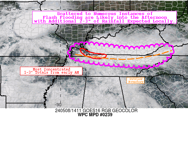
Areas affected...TN/KY/VA border region

Concerning...Heavy rainfall...Flash flooding likely

Valid 081420Z - 082020Z

Summary...Scattered to numerous instances of flash flooding are
likely into the afternoon with additional 2-3" of rainfall
expected locally. Some flash flooding may be significant.

Discussion...Heavy showers and thunderstorms are ongoing across
the TN/KY/VA border region this morning, resulting in localized
totals of up to 2-3" over the past several hours (per MRMS
estimates). This heavy rainfall has occurred after a period of
convective organization along a west-to-east oriented outflow
boundary from prior convection overnight. This is occurring within
a broad warm sector stretching across most of the eastern CONUS,
and the mesoscale environment is characterized by an ML CAPE
gradient of 1000-2500 J/kg, PWATs of 1.0-1.7 inches (near the 90th
percentile, per SPC sounding climatology), and deep layer shear of
40-60 kts.

Hi-res CAMs may have had the right idea, but have been far too
slow based on the trends with the activity this morning. This is
likely related to how defined of a forcing mechanism the outflow
boundary became, and how the CAMs have struggled to depict this
key mesoscale feature. The HRRR (as usual) does a bit better with
this depiction given the hourly refresh cycle, and this would
suggest that an additional 2-3" of rainfall are possible through
20z. Unfortunately most of this heavy rainfall will occur over
much of the same areas, given the west-to-east movement along the
boundary with the greatest total atmospheric moisture (and
low-level transport) in western KY and northern Middle TN. While
this suggests scattered to numerous instances of flash flooding
are likely (given 3-hr FFGs averaging only 1.5" or so), there may
also be localized instances of significant flash flooding. In
addition, heavy rainfall looks to continue across much of this
same region well late into the evening and overnight, so flash
flooding may become more widespread (and severe) heading into the
evening (and will likely necessitate subsequent discussions).

Churchill

ATTN...WFO...JKL...LMK...MEG...MRX...OHX...PAH...RLX...RNK...

ATTN...RFC...LMRFC...OHRFC...NWC...

LAT...LON   37428833 37288668 37068453 37298211 36868167
            35908302 35898539 36118752 36488917 37128912
Download in GIS format: Shapefile
| KML
Last Updated: 1022 AM EDT Wed May 08 2024
|


