| WPC Met Watch |
|
|
Mesoscale Precipitation Discussion: #0025 (2021) |
|
(Issued at 407 PM EST Thu Feb 18 2021
) |
|
| MPD Selection |
|
|
|
|
|

Mesoscale Precipitation Discussion 0025
NWS Weather Prediction Center College Park MD
407 PM EST Thu Feb 18 2021

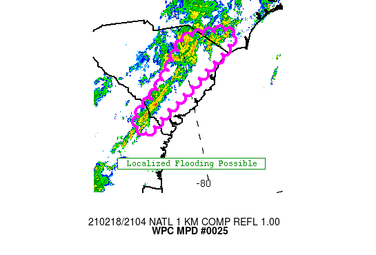
Areas affected...Southeast GA, eastern SC and southern NC

Concerning...Heavy rainfall...Flash flooding possible

Valid 182107Z - 190107Z

Summary...A narrow training band of convection will pose a
localized flood risk into the early evening over portions of
southeast GA into eastern SC and far southern NC.

Discussion...A subtle mid level wave is likely responsible for the
uptick in elevated convection along this corridor...with hourly
rainfall locally exceeding 1" within the narrow training axis.
While much of the region has received ~1-2" of rain over the past
day, there has been a narrow axis of 3-4" near the GA/SC border.
The whole region remains a bit more susceptible than normal to
flooding...given elevated streamflows and anomalous soil
moisture...however the axis of 3"+ rain over the past day is
likely most susceptible. The core of this current training axis is
currently just north of that corridor...but it is close, with some
southward shifting with time a possibility. Recent satellite
trends seem to indicate a slight uptick in cooler cloud tops, and
also note periodic upticks in lightning near the GA/SC border and
over eastern SC. Thus it would appear like we should see a
maintenance of periodic training cells over the next few hours
along this corridor.

Thus overall, the broad nature of susceptible antecedent
conditions suggests a localized flash flood risk exists with this
activity, along with ponding of water and minor areal
flooding...with a good percentage of the rain becoming runoff
given soil conditions. If the band does sink south into the areas
hardest hit this morning, then a more elevated flash flood risk
could evolve over that corridor. Another area of higher rainfall
already today is near the SC/NC border north of Myrtle Beach. This
activity may eventually sink south into those areas as well...so
another region to monitor over the next few hours.

Chenard

ATTN...WFO...CAE...CHS...ILM...

ATTN...RFC...SERFC...NWC...

LAT...LON   34497881 34427847 34297831 33967864 33807891
            33467951 33008023 32788062 32638092 32348133
            32208168 32468186 32778170 33098121 33458084
            33738056 34158017 34477986 34477936
Last Updated: 407 PM EST Thu Feb 18 2021
|


