| WPC Met Watch |
|
|
Mesoscale Precipitation Discussion: #0007 (2019) |
|
(Issued at 1051 PM EST Fri Jan 11 2019
) |
|
| MPD Selection |
|
|
|
|
|

Mesoscale Precipitation Discussion 0007
NWS Weather Prediction Center College Park MD
1051 PM EST Fri Jan 11 2019

Areas affected...Coastal Southern California

Concerning...Heavy rainfall...Flash flooding possible

Valid 120351Z - 120945Z

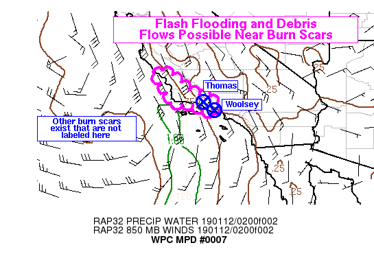
Summary...Rain bands will begin to affect parts of the southern
California coast tonight, particularly the Transverse Ranges in
Santa Barbara and Ventura Counties. Rain rates may reach just
under 1 in/hr, which could cause flash flooding and debris flows
in the vicinity of burn scars.

Discussion...Heavy convective rain bands were beginning to
approach the southern California coast near Point Conception as of
0330Z, based on the KVBX radar. These were embedded in an area of
low-mid level convergence and a corridor with PWs approaching 1
inch. The 00Z VBG sounding recorded a 0.77 inch PW, but may have
been just east of the corridor of highest PWs at the time. These
values are above average and near the 90th percentile for January
along this portion of the California coast, but are not as high as
you might see with a strong atmospheric river event. However, some
marginal instability does exist, and RAP analysis showed MUCAPE
values beginning to push into the 200-300 j/kg range along the
Santa Barbara coast at 03Z. This is expected to lead to some
convective rain bands and lead to a threat of localized heavy
rainfall on the coast, particularly in Santa Barbara and Ventura
Counties where there will be a more considerable component of the
low-mid level flow orthogonal to the Transverse Ranges. The best
rates may be off the ridge tops and closer to the coast, as this
is not a true atmospheric river event and the heaviest rain rates
may be driven more by convective banding and resulting focused
smaller-scale ascent rather than strong orographic forcing. As a
result, the greatest concern for flash flooding would be near
recent burn scars that extend closer to the coast such as scars
from the Thomas and Woolsey Fires. Impacts can't be ruled out in
other locations and near other burn scars, though. Hi-res models
show a strong likelihood of rain rates exceeding 0.5 in/hr with
the 18Z HREF neighborhood probabilities exceeding 50 percent in
Santa Barbara County later tonight. Recent runs of the HRRR also
show some rain rates approaching 1 in/hr and this would be
possible if the aforementioned marginal instability can spread
east along the coast.

Lamers

ATTN...WFO...LOX...

ATTN...RFC...CNRFC...

LAT...LON   35732083 35352030 35011997 34781948 34581875
            33981886 34081937 34311969 34422064 34992090
            35652137
Last Updated: 1051 PM EST Fri Jan 11 2019
|


