| WPC Met Watch |
|
|
Mesoscale Precipitation Discussion: #0178 |
|
(Issued at 512 PM EDT Fri Apr 26 2024
) |
|
| MPD Selection |
|
|
|
|
|

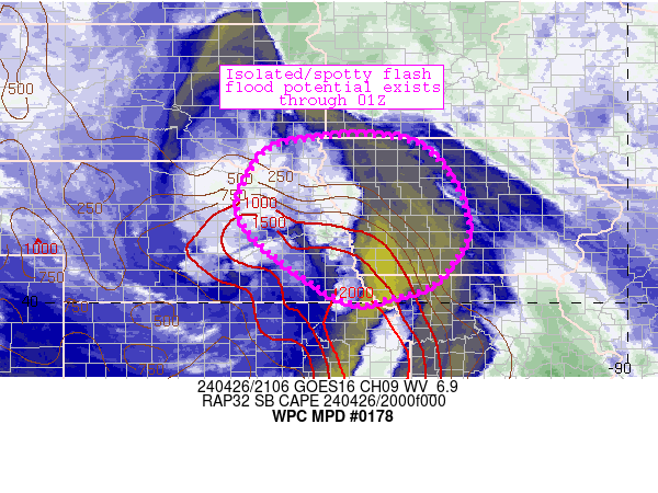
Mesoscale Precipitation Discussion 0178
NWS Weather Prediction Center College Park MD
512 PM EDT Fri Apr 26 2024

Areas affected...northeastern Nebraska, western Iowa, southeastern
South Dakota

Concerning...Heavy rainfall...Flash flooding possible

Valid 262107Z - 270100Z

Summary...Spotty/isolated flash flood potential exists with
vigorous convection moving northward/northeastward through the
region.

Discussion...Deep, robust convection has materialized across the
discussion area generally along an arc from northwest of Columbus,
NE through Omaha and southward to near Manhattan, KS.  The storms
themselves are moving quickly northward at around 25-35 knots due
to strong steering flow aloft (45-60 kt southerly flow at 500mb).
Despite the quick storm movement, a few spots of 1-1.5 inch/hr
rain rates have been estimated per MRMS - highest where cell
mergers have occurred northwest of Columbus.  Convective trends
from Omaha, NE southward suggest that a limited degree of training
could boost rain rates as cells mature there and move
north-northeastward into Iowa beginning in the next 30-60 minutes.


The spots of heavier rain rates are occurring atop wet soils that
have experienced 1-2 inches of estimated rainfall over the past 24
hours.  FFG thresholds are in the 1-1.5 inch/hr range, suggesting
that flash flood potential will likely be tied to cell mergers and
localized training that can prolong rain rates on a localized
basis.  Moderate instability is expected to shift northward across
much of Iowa this afternoon/evening ahead of the convection,
sustaining their intensity and flash flood risk.  The duration of
this risk is expected to last through 01Z or so, but remain
relatively isolated and spotty in nature.

Cook

ATTN...WFO...DMX...EAX...FSD...GID...OAX...

ATTN...RFC...MBRFC...NCRFC...NWC...

LAT...LON   43439717 43409456 41789343 40519403 40129499
            40089616 41579813 42709810
Download in GIS format: Shapefile
| KML
Last Updated: 512 PM EDT Fri Apr 26 2024
|


