| WPC Met Watch |
|
|
Mesoscale Precipitation Discussion: #0850 (2021) |
|
(Issued at 602 PM EDT Sat Aug 21 2021
) |
|
| MPD Selection |
|
|
|
|
|

Mesoscale Precipitation Discussion 0850
NWS Weather Prediction Center College Park MD
602 PM EDT Sat Aug 21 2021

Areas affected...South-Central New Jersey...Far Southeastern
Pennsylvania

Concerning...Heavy rainfall...Flash flooding likely

Valid 212200Z - 220400Z

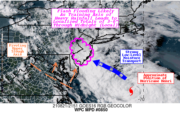
Summary...An axis of very heavy rainfall is expected to develop
with 2-3+"/hr rates leading to some totals of 3-6 inches.
Localized flash flooding is likely.

Discussion...As Hurricane Henri moves northward late this
afternoon and evening, an axis of very heavy rainfall is expected
to develop across portions of south-central New Jersey and far
southeastern Pennsylvania. Strong low-level moisture transport
from the east (via Henri) is leading to precipitable water values
building to 2.1 to 2.3 inches, while an upper-level trough axis
and associated jet streak (right entrance region) will provide
enhanced lift aloft. This banded feature will likely initiate with
a NNW to SSE orientation, gradually pivoting counter-clockwise
(from the WNW to ESE) towards midnight (local). The nearly
stationary nature of the heavy rain axis will allow for repeating
of very efficient rates (2-3+"/hr) as strong moisture transport
and upper-level lift allow SB CAPE to remain elevated around
1000-1500 J/kg.

Hi-res CAM guidance (12z HREF and more recent HRRR runs) have been
consistent in painting a localized swath of 3-6 inches of rainfall
from near Atlantic City, NJ to the Philadelphia, PA metropolitan
area through midnight local. The 12z HREF 40km neighborhood
probabilities depict a greater than 30% chance of 3" exceedance
over 3 hours and a greater than 20% chance of 5" exceedance over
12 hours (ending 06z). In addition, the HRRR has been very
consistent run-to-run producing a swath of 2-6 inches. Given this
guidance and the overall synoptic and mesoscale setup, localized
flash flooding is considered likely (with more sensitive urbanized
areas of the greatest concern).

Churchill

ATTN...WFO...PHI...

ATTN...RFC...MARFC...NWC...

LAT...LON   40957514 40527463 39987400 39557418 38907481
            39207508 39377520 39587533 39827543 40297557
            40487553
Last Updated: 602 PM EDT Sat Aug 21 2021
|


