| WPC Met Watch |
|
|
Mesoscale Precipitation Discussion: #1126 (2021) |
|
(Issued at 426 AM EST Fri Nov 12 2021
) |
|
| MPD Selection |
|
|
|
|
|

Mesoscale Precipitation Discussion 1126
NWS Weather Prediction Center College Park MD
426 AM EST Fri Nov 12 2021

Areas affected...Northwest OR...Western WA

Concerning...Heavy rainfall

Valid 120925Z - 121800Z

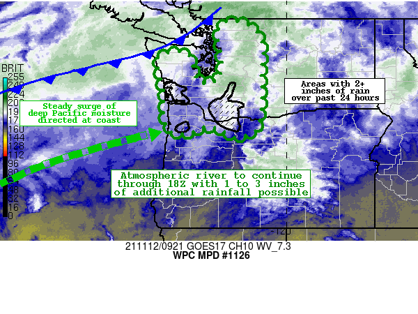
SUMMARY...Atmospheric river conditions will continue to produce
heavy rainfall through the mid-morning hours for much of western
Washington and northwest Oregon.  An additional 1 to 3 inches of
rainfall for orographically favored locations will lead to
additional instances of enhanced run-off concerns and possible
flooding.

DISCUSSION...Recent GOES-17 satellite imagery continues to portray
a corridor of enhanced moisture that is associated with an
atmospheric river oriented from WSW to ENE, originating from near
30 degrees north over the central Pacific.  Regional Doppler
radars indicate a substantial area of moderate to heavy showers
moving across western Washington and northwest Oregon,
particularly across the coastal ranges and the western slopes of
the Cascades.  It is these areas where the flow will be orthogonal
to the terrain and the greatest rainfall totals realized.

A strong west-southwest low-level jet on the order of 50 mph, in
combination of IVT values of 600-800 kg/m/s and PWs approaching
1.5 inches within the moisture plume, will sustain widespread
moderate to heavy rainfall through sunrise, followed by a gradual
abatement in intensity going through the middle to late morning
hours.  The latest CAM guidance is suggesting the potential for up
to 3 inches of additional rainfall through 18Z, particularly with
the HRRR and WRF.

Given the saturated soils with 2-4 inches of rainfall over the
past 24 hours, there will be growing concerns for runoff problems
and localized flooding.  Some of the area burn scars will be more
sensitive to these heavier rains and should be closely monitored.

Hamrick

ATTN...WFO...OTX...PDT...PQR...SEW...

ATTN...RFC...NWRFC...NWC...

LAT...LON   48912204 48872145 48522095 47852078 47232084
            46362082 45642090 45252106 45102139 45052178
            45122194 45282212 45382246 45412274 45192328
            45172373 45282399 45572406 45792409 46612412
            47132423 47622434 47852407 47912358 47832326
            47512315 47022303 46852276 46882244 47042220
            47272218 47712216 48132223 48602229
Last Updated: 426 AM EST Fri Nov 12 2021
|


