| WPC Met Watch |
|
|
Mesoscale Precipitation Discussion: #1073 (2022) |
|
(Issued at 636 PM EDT Mon Oct 03 2022
) |
|
| MPD Selection |
|
|
|
|
|

Mesoscale Precipitation Discussion 1073
NWS Weather Prediction Center College Park MD
636 PM EDT Mon Oct 03 2022

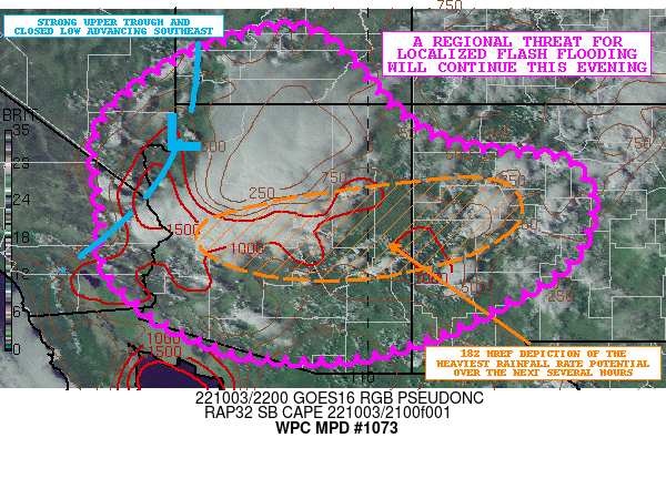
Areas affected...Southern UT...Far Southern NV...Far Southeast
CA...Much of AZ...Western/Central NM

Concerning...Heavy rainfall...Flash flooding possible

Valid 032235Z - 040435Z

SUMMARY...A regional threat for localized flash flooding will
continue into the evening hours from showers and thunderstorms
capable of producing rainfall rates of as much as 1 to 2
inches/hour.

DISCUSSION...A vigorous upper-level trough and embedded closed low
continues to drop southeast this afternoon across southern NV and
into central and northern AZ. This energy is interacting with a
well-defined axis of higher moisture/PWs across the region
(especially in the 700/500 mb layer) along with a moderately
unstable airmass in the boundary layer characterized by SBCAPE
values of as much as 1500 to 2000 j/kg.

The result over the last few hours has been a few areas of
well-organized convection with multiple clusters of strong,
multi-cellular convection dropping down across areas of western
and especially central AZ. Elsewhere, across areas of southern UT,
far southern NV, far southeast CA and areas off to the east into
western/central NM, there has generally be the development of
scattered, but locally slow-moving, pulse-cell convection.

Already there has been some areas of flash flooding from very
heavy rainfall rates that have reached into the 1 to 2 inch/hour
range, and similar rates are expected going through the remainder
of the afternoon and into the evening hours as heavy showers and
thunderstorms continue to percolate across the region.

The more focused and organized threat of convection will generally
tend to be across areas of central/eastern AZ and into western NM
based on a consensus of the 18Z HREF guidance and the last few
HRRR runs. Radar trends over the last hour suggest there may be
the development and evolution of a MCV over central AZ which would
then likely advance east and help maintain convection that is at
least semi-organized over the next few hours. Regardless, areas of
central/eastern AZ and western NM should see the stronger zone of
upper-level forcing from the robust upper trough/closed low
dropping southeast across central/northern AZ. By later the
evening, areas of central NM may have a threat for some locally
heavy rains as the aforementioned energy arrives across this area.

Some additional spotty rainfall totals of 2 to 3 inches will be
possible going through the evening hours, and this coupled with
the heavy hourly and sub-hourly rainfall rates will continue to
favor concerns for some flash flooding. This will include
sensitive locations such as the slot canyons of southern UT and
northern AZ, but also the vulnerable dry washes and burn scar
locations elsewhere across the region.

Orrison

ATTN...WFO...ABQ...EPZ...FGZ...GJT...PSR...SLC...TWC...VEF...

ATTN...RFC...CBRFC...CNRFC...WGRFC...NWC...

LAT...LON   38551191 38541134 38161064 37240981 36470896
            36080812 35890660 35750578 35160535 34440538
            33630585 32780728 32150858 31701036 31751245
            32061346 32391418 32891488 33651552 34671554
            36121570 36901533 37881402 38381270
Last Updated: 636 PM EDT Mon Oct 03 2022
|


