| WPC Met Watch |
|
|
Mesoscale Precipitation Discussion: #0920 (2021) |
|
(Issued at 916 AM EDT Wed Sep 01 2021
) |
|
| MPD Selection |
|
|
|
|
|

Mesoscale Precipitation Discussion 0920
NWS Weather Prediction Center College Park MD
916 AM EDT Wed Sep 01 2021

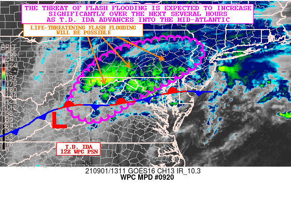
Areas affected...Mid-Atlantic States

Concerning...Heavy rainfall...Flash flooding likely

Valid 011315Z - 011915Z

SUMMARY...Flash flooding, some of it significant and potentially
life-threatening, is expected going through the late morning and
early afternoon hours as T.D. Ida approaches the region from the
southwest.

DISCUSSION...The latest GOES-16 IR satellite imagery along with
surface and radar observations shows T.D. Ida advancing across the
central Appalachians as the system continues to advance off to the
east-northeast. The system is gradually transitioning to a
post-tropical/extratropical low center as it begins to merge with
a frontal zone draped over the central Appalachians and the
Mid-Atlantic region and also comes under the influence of an upper
trough digging across the OH/TN Valley region.

Radar and satellite imagery shows a very impressive area of heavy
rainfall currently crossing the higher terrain of central WV, and
extending northeast up across eastern WV, western MD and a large
area of southwest to central PA.

The MRMS-based KDP/ZDR analysis shows a narrow axis of extremely
efficient rainfall (high KDP/low ZDR values) across central WV
currently, and an extrapolation of this axis of enhanced rainfall
rates will allow for it to cross the WV/MD Panhandles and advance
into south-central PA going through the late-morning and early
afternoon time frame. Meanwhile, adjacent areas a bit farther
north from southwest to central PA are likewise seeing very
efficient rainfall with high rain rates. Favoring this area wide
continues to be a high PW environment with values locally over 2
inches, and a deeply warm/moist column as seen in the 12Z PIT/IAD
RAOB soundings.

Very strong low to mid-level forcing is driving this enhanced
rainfall with a combination of strong 925/700 mb frontogenesis,
modest elevated instability, and strongly divergent flow aloft
associated with a strengthening mid to upper-level deformation
zone all working in tandem as Ida advances off to the
east-northeast and gradually merges with the aforementioned
frontal zone.

The 06Z HREF suite of guidance and recent HRRR runs show
particularly heavy and focused rainfall impacting areas along and
north of the path of Ida going into the early afternoon time
frame. There is the expectation of seeing some hourly rainfall
amounts of 2 to 3+ inches, and storm total amounts going through
18Z (2pm EDT) of 4 to 6 inches with isolated heavier amounts.

Flash flooding is expected, and some of it is likely to be
significant and potentially life-threatening given the high
rainfall rates and storm total potential in a rather short amount
of time. Flash flood emergency level rainfall impacts are possible
as we head into the afternoon hours, and additional MPDs will be
issued accordingly as Ida advances into the Mid-Atlantic region
today.

Orrison

ATTN...WFO...BGM...CTP...LWX...PBZ...PHI...RLX...RNK...

ATTN...RFC...MARFC...OHRFC...NWC...

LAT...LON   41557618 41347487 40687476 39997557 38767783
            37917918 37688001 38028080 38408099 39558047
            40467965 41037857 41287765
Last Updated: 916 AM EDT Wed Sep 01 2021
|


