| WPC Met Watch |
|
|
Mesoscale Precipitation Discussion: #0919 (2021) |
|
(Issued at 749 AM EDT Wed Sep 01 2021
) |
|
| MPD Selection |
|
|
|
|
|

Mesoscale Precipitation Discussion 0919
NWS Weather Prediction Center College Park MD
749 AM EDT Wed Sep 01 2021

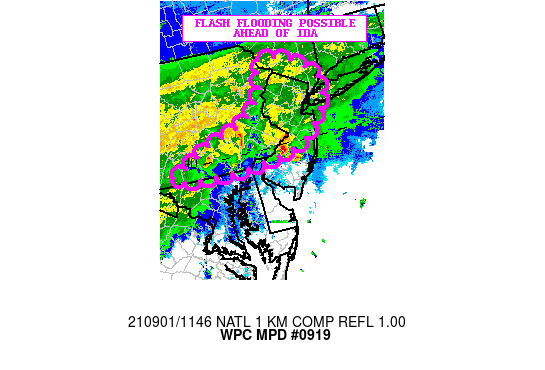
Areas affected...Southeast PA...Western/Northern NJ...Far
Southeast NY

Concerning...Heavy rainfall...Flash flooding possible

Valid 011148Z - 011600Z

SUMMARY...Very heavy rainfall this morning will be increasing the
threat of flash flooding going through the mid to late morning
hours as T.D. Ida gradually advances into the Mid-Atlantic region.

DISCUSSION...The latest radar imagery shows a cluster of heavy
showers and a few thunderstorms advancing northeast across areas
of southeast PA and moving into western NJ. The activity is
focused in an elevated fashion northeast of a quasi-stationary
front draped from central VA east to the Delmarva, and along the
north side of a well-defined instability gradient pooled along it.
Some of this convection is the remnants of earlier supercell
thunderstorm activity that had impacted the D.C. to Baltimore I-95
corridor earlier this morning.

Rainfall rates with the elevated convection remains quite high
owing to the highly efficient environment that is in place more
broadly across the Mid-Atlantic region. Deep tropical moisture
surging north and northeast ahead of T.D. Ida is fostering PWs of
1.8 to 2 inches and this coupled with an otherwise deep warm layer
with high wet-bulb freezing levels is favoring enhanced rainfall
rates that are over 2 inches/hour with the stronger cells.

Over the next few hours, there will likely be a continuation of
areas of relatively heavy shower and thunderstorm activity
focusing northeast of the aforementioned front which should begin
to gradually begin lifting north as a warm front later this
morning. Given the rather favorable effective bulk shear, elevated
instability, and robust warm air advection associated with strong
southerly flow ahead of T.D. Ida, the convective threat should be
maintained.

The activity should continue to impact a fairly large area of
southeast to east-central PA and advancing through a large area of
western and northern NJ through late morning. Areas of far
southeast NY including the greater New York City area will also
gradually be getting into some heavy rainfall although the
heaviest for the morning time frame should remain farther south.

Given the high rainfall rates, there will be concerns for some
flash flooding this morning and especially given some of the more
sensitive urban corridors across southeast PA and into
western/northern NJ. It should be strongly noted that there is
likely to be a much more significant threat of flash flooding
later in the day as Ida approaches the region. This will
accordingly be handled with additional MPDs.

Orrison

ATTN...WFO...BGM...CTP...LWX...OKX...PHI...

ATTN...RFC...MARFC...NERFC...NWC...

LAT...LON   41627509 41567435 41087367 40657371 40157414
            39897465 39767545 39707638 39787772 40017725
            40307666 40487592 40887527 41307505
Last Updated: 749 AM EDT Wed Sep 01 2021
|


