| WPC Met Watch |
|
|
Mesoscale Precipitation Discussion: #0874 (2020) |
|
(Issued at 1129 AM EST Thu Dec 24 2020
) |
|
| MPD Selection |
|
|
|
|
|

Mesoscale Precipitation Discussion 0874
NWS Weather Prediction Center College Park MD
1129 AM EST Thu Dec 24 2020

Areas affected...Central Virginia...West-Central Maryland...DC...

Concerning...Heavy rainfall...Flash flooding possible

Valid 241630Z - 242130Z

SUMMARY...Training moderate showers with increasing rain-rates up
to .75"/hr and totals of 2-3" over saturated, low FFG grounds pose
a possible isolated flash flooding concern up to and through 21z.

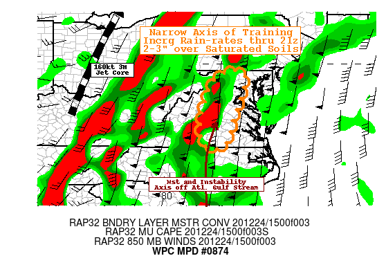
DISCUSSION...Radar mosaic, surface obs and RAP CAPE analysis
depict a focused north-south oriented band of light to moderate
showers focused at a small angle boundary-layer (BL) convergence
band across north-central NC into south-central VA.   This axis
originates from enhanced low level theta-E from the Gulf Stream
off the GA/SC coast lifting in advance of the sharpening amplified
trof across the OH/TN Valleys attm.  A subtle inflection exists
just upstream across AL at this time that is tilting a bit
forward, this placement should allow for slight backing of the
low-level flow while increasing BL flux convergence in the same
general vicinity and orientation through the afternoon hours.  As
such deep steering flow, that is confluent to the south of it will
exist to support a narrow corridor of training and continuous
rainfall.

RAP and HRRR short-term forecasts support increasing flow from 30
to 45kt at the BL. Tds have already risen to the mid-50s across NC
and nearing low 50s in central VA, with a bit of filtered solar
insolation seen in some breaks through NC/SC, Cape is expected to
increase to marginal values of 250 J/kg across the southern
portion of the area of concern.  As such some embedded weak
convective cores are expected to develop in the 18-19z time-frame
and strengthen through 21z.  Solid low level moisture within the
cloud depth should support modest rain-rates up to .5"/hr.  The
HRRR, HRRRv4 and 12z NMMB are more aggressive to suggest possible
.75"/hr totals, which seem plausible given current trends seen in
the moisture/instability fields.

Combine this with the training profiles and there is a suggestion
of 2-3" 3hr totals across central VA toward NoVA.  This is nearing
3hr FFG values in some locations across this region given last 30
day above normal precip anomalies and ground-moisture depth
ratios, greater run-off may occur and pose possible isolated flash
flooding conditions through 22z, particularly in along the front
range of the Blue Ridge and the DC and Richmond Metro areas where
FFG values are most compromised.

Gallina

ATTN...WFO...AKQ...LWX...RNK...

ATTN...RFC...MARFC...SERFC...NWC...

LAT...LON   39707738 39387688 37977731 36627774 36627850
            36927868 37577872 39157826
Last Updated: 1129 AM EST Thu Dec 24 2020
|


