| WPC Met Watch |
|
|
Mesoscale Precipitation Discussion: #0864 (2019) |
|
(Issued at 654 PM EDT Wed Sep 18 2019
) |
|
| MPD Selection |
|
|
|
|
|

Mesoscale Precipitation Discussion 0864
NWS Weather Prediction Center College Park MD
654 PM EDT Wed Sep 18 2019

Areas affected...Southeast Texas, Far Southwest Louisiana

Concerning...Heavy rainfall...Flash flooding possible

Valid 182250Z - 190345Z

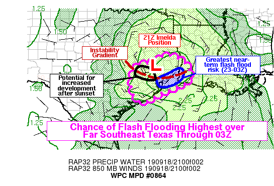
Summary...Tropical rain bands and embedded thunderstorms will
continue into the evening hours, primarily across southeast Texas.
Rain rates may exceed 2-3 inches per hour at times, which could
lead to flash flooding, particularly in areas that have already
received heavy rainfall in the past 24 hours.

Discussion...Tropical Depression Imelda continues to slowly drift
across southeast Texas. Stronger convective rain bands have
redeveloped this afternoon around the periphery of the storm,
closer to the Upper Texas Coast and the stronger instability near
and over the Gulf of Mexico. These rain bands have become
increasingly organized, but observed storm motions have suggested
they are not oriented in a configuration for extended periods of
training yet. Relatively high instantaneous rain rates are
suggested by the combination of strong instability and very high
PW values (as high as 2.5 inches or so), a very deep warm cloud
layer associated with the tropical system, and relatively high KDP
values sampled by the KHGX radar. This should pose a risk of some
flash flooding in the next few hours along the Upper Texas Coast.
The highest changes would be in far SE TX into far SW LA, or
roughly between HOU and LCH. Recent runs of the HRRR have been
very consistent in concentrating heavy rain bands in this area
between 23-03Z, and it aligns with current radar trends and the
strongest low-level moisture convergence analyzed by the RAP (and
projected over the next few hours). Two recent GPS observations
between Galveston Bay and the Sabine River provided PW values of
2.6 to 2.7 inches, so that is also very close to a maximum in
tropsopheric moisture, and any rain bands would be expected to be
very efficient in that area.

Observed rain bands to the southwest of Houston as of 2230Z had a
relatively significant component of the storm motion perpendicular
to the major axis of the bands. This suggests continued
propagation toward the Matagorda and Brazoria County coasts and a
more localized flash flood risk in the next few hours.
Instantaneous rain rates will be quite high, and the thunderstorm
cluster near ARM was one of the largest on radar at this time, so
localized swaths of heavy rainfall capable of producing flash
flooding cannot be ruled out -- particularly as the convective
clusters approach the areas that have seen over 10 inches of rain
from last night into this morning.

As we move later into the evening, there is potential for
additional convective development closer to the center of Imelda,
and upstream along the instability gradient from the expected
concentrated area of convection in SE TX. Many (but not all)
hi-res model runs, including recent HRRR runs, depict a scenario
like this. Model forecasts do show an increase in low-level
convergence closer to the center later this evening, and this
seems plausible with an existing instability gradient. The
gradient is reflected by a band of low clouds in GOES-16 visible
satellite imagery from near TPL-CXO, and this same area (or
perhaps just to the south) would be favored for additional
development closer to 03Z. It is worth monitoring the locations
just southwest of Imelda's center this evening, as hi-res models
suggest the convective bands would be likely to be very slow
moving and efficient rainfall producers, which could develop into
the dominant flash flood threat during the overnight hours.

Lamers

ATTN...WFO...HGX...LCH...SHV...

ATTN...RFC...LMRFC...WGRFC...

LAT...LON   31269461 31239398 30789333 30029307 29579378
            29179480 28669578 29199636 30059641 30729611
            30889520
Last Updated: 654 PM EDT Wed Sep 18 2019
|


