| WPC Met Watch |
|
|
Mesoscale Precipitation Discussion: #0859 (2021) |
|
(Issued at 554 PM EDT Sun Aug 22 2021
) |
|
| MPD Selection |
|
|
|
|
|

Mesoscale Precipitation Discussion 0859
NWS Weather Prediction Center College Park MD
554 PM EDT Sun Aug 22 2021

Areas affected...Western New England, Southeast NY, Northern NJ,
Eastern PA

Concerning...Heavy rainfall...Flash flooding possible

Valid 222200Z - 230400Z

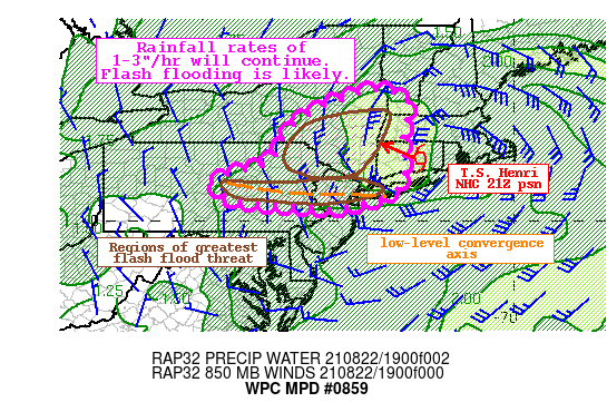
Summary...Tropical Storm Henri will continue to shift NW this
evening bringing torrential rainfall to parts of New England and
the Mid-Atlantic. Additional rainfall of 2-4" with locally higher
amounts will likely produce flash flooding.

Discussion...Tropical Storm Henri was located at 21Z to be about
20 miles SE of Hartford, CT and moving WNW at 7 mph. Drier air
noted on GOES-E mid-level WV imagery was lifting northward across
Long Island and rotating around the center of Henri, causing a
sharp cutoff in rainfall across eastern New England at this hour.
Some enhanced ascent at the edge of this dry slot interacting with
the extremely moist environment west of Henri is enhancing the
rain shield W/SW of the center. Within this impressive plume,
rainfall rates have recently been estimated at 1-2"/hr on local
radars, with 3-hr rainfall measured as high as 2.6" at White
Plains, NY. As Henri lifts slowly NW this evening, this heavy
rainfall is likely to continue across parts of NY, NJ, and PA,
with two distinct areas of heavy rainfall producing the highest
flash flood risk.

Across southeast NY and far northeast PA, moist advection will be
pronounced from the east. PWs according to GPS are as high 2.3"
over western CT and MA, nearly 3 standard deviations above the
climo mean according to NAEFS ensemble tables, and these will
continue to push westward. At the same time, lift across this
region will continue to enhance through low-level convergence as
the 850mb winds rise to 30-40 kts, exceeding the mean 0-6km mean
which is progged to be 25-30 kts. This convergence will be topped
by increasing LFQ diffluence as the poleward arcing jet streak
expands into southern New England. The overlap of this ascent
within the extremely moist environment will continue to produce
rounds of heavy rainfall which the HREF indicates will feature
rates of 1-2"+/hr at times as efficient warm rain processes
dominate thanks to freezing levels that are above 15,000 ft.
Despite rapid cell motions to the W/SW, training of echoes is
likely, and rainfall could add up to 2-4" with locally higher
amounts in the next 6 hours. This will occur atop already
saturated soils, and flash flooding is likely, with isolated
significant flash flooding possible should the heaviest rain fall
atop the already saturated grounds where locally 8" of rain has
already occurred, or in urban areas.

An additional area of enhanced flash flood risk appears to be
developing along a west to east oriented convergence boundary from
central PA through western Long Island. Here, 925-850mb ascent is
maximized due to speed shear, and is likely to enhance as the
Henri shifts westward enhancing the winds north of this boundary.
Recent radar suggests this band is nearly stationary, and while
the high-res is modest in the evolution of this feature, it is
likely it will remain nearly in place, while ascent intensifies
this evening. PWs across this region are also well above normal,
around 1.75" according to GPS observations, so rainfall rates of
1"+/hr are likely. While the rain rates then are not expected to
be as significant as points north, continuous heavy rainfall will
likely produce flash flooding as an additional 1-3" of rainfall
occurs, with locally higher amounts, especially in northern NJ
where FFG is lowest and the HREF indicates a better than 50%
chance of exceedance.

Weiss

ATTN...WFO...ALY...BGM...BOX...CTP...OKX...PHI...

ATTN...RFC...MARFC...NERFC...NWC...

LAT...LON   43357348 43157274 42607278 42067287 41487281
            41087287 40707314 40497389 40297467 40337473
            40427577 40477672 40577731 41047775 41257702
            41507624 42317578 42787516 43187426
Last Updated: 554 PM EDT Sun Aug 22 2021
|


