| WPC Met Watch |
|
|
Mesoscale Precipitation Discussion: #0855 (2021) |
|
(Issued at 600 AM EDT Sun Aug 22 2021
) |
|
| MPD Selection |
|
|
|
|
|

Mesoscale Precipitation Discussion 0855
NWS Weather Prediction Center College Park MD
600 AM EDT Sun Aug 22 2021

Areas affected...Long Island...Southern New England

Concerning...Heavy rainfall...Flash flooding likely

Valid 221000Z - 221600Z

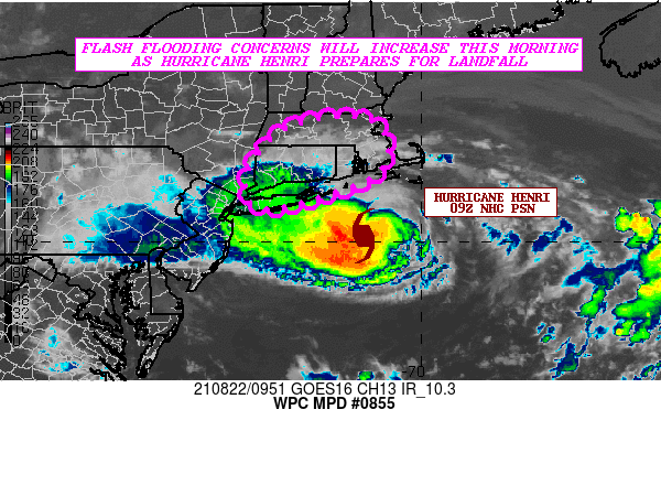
SUMMARY...Hurricane Henri continues steadily north toward eastern
Long Island and southern New England. Bands of heavy rain will be
moving inland over the next few hours, and there will be an
increasing threat of some flash flooding.

DISCUSSION...The latest GOES-16 IR satellite imagery shows
Hurricane Henri advancing steadily northward, and as of 09Z, the
storm was centered just 80 miles south-southeast of Montauk Point,
NY.  Bands of heavy showers are beginning to move onshore across
portions of eastern Long Island, southeast CT, RI, and southeast
MA as the northwest flank of Henri impinges on the region. The
latest satellite imagery though shows Henri gradually getting
caught by the well-defined upper low over the Mid-Atlantic coastal
plain, and this should allow Henri to begin turning to the
north-northwest by mid-morning. As a result, this will allow these
heavier rain-bands to overspread the remainder of southern New
England in a few hours.

Given a relatively more stable environment and cooler SSTs along
the track of Henri over the next several hours, and with some
mid-level dry air wrapping around the northern and eastern
quadrants of the storm, there is a likelihood that some of the
central convection associated with Henri will begin to weaken as
the systems prepares for a landfall toward midday. However, there
will be a substantial amount of moisture transport/forcing
gradually focusing around the western and southwest quadrants of
the circulation which will be aided by a growing baroclinic
interaction with the aforementioned upper low. As a result, the
heaviest rainfall should tend to be noted along and to the left of
the storm track going toward midday, with more shallow convective
bands riding up along the eastern flank of the system.

Expect some hourly rainfall totals of as much as 1 to 2 inches
with the heavier rainfall bands this morning as Henri approaches
the coast, with some storm total amounts by midday across eastern
Long Island and southern New England in the 2 to 4 inch range with
isolated heavier amounts. This is supported by the latest
consensus of hires model guidance as shown by the 00Z/06Z HREF.
Additional rainfall will add to these totals beyond this period as
the storm makes landfall and advances inland.

Expect some areas of flash flooding to be likely going through the
morning hours. It should be noted that the antecedent conditions
across the region are rather wet given the recent rainfall from
Post-T.C. Fred just a few days ago, so these heavy rains
associated with Henri will encourage some more efficient runoff
concerns.

Orrison

ATTN...WFO...ALY...BOX...OKX...

ATTN...RFC...NERFC...NWC...

LAT...LON   42637193 42617119 42387084 42007069 41607078
            41277120 41077180 40837250 40697330 40967371
            41697355 42337293
Last Updated: 600 AM EDT Sun Aug 22 2021
|


