| WPC Met Watch |
|
|
Mesoscale Precipitation Discussion: #0847 (2022) |
|
(Issued at 737 PM EDT Mon Aug 22 2022
) |
|
| MPD Selection |
|
|
|
|
|

Mesoscale Precipitation Discussion 0847
NWS Weather Prediction Center College Park MD
737 PM EDT Mon Aug 22 2022

Areas affected...South-central Texas

Concerning...Heavy rainfall...Flash flooding possible

Valid 222345Z - 230500Z

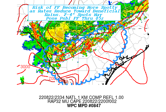
SUMMARY...Scattered remaining elevated heavy rainfall producing
thunderstorms may linger over some locations with high efficiency
to support 2-4" totals and low-end flash flooding.

DISCUSSION...Regional RADAR mosaic depicts a broken line of
thunderstorms slowly drifting southward as the outflow boundary
quickly moves away.  Cold pool is increasingly getting shallower
as it races southward, yet sufficient convergence along the top of
the wedge to maintain some convective development given modest
remaining 1500-2000 J/kg MUCAPE.  Some continued surface based
cells are developing along the leading edge, they are reducing in
coverage with time likely to fade quicker after nightfall.
Still, the core of the moisture axis remains along the lower Hill
country into the Coastal Plain with 2.1-2.3" TPW values still
available for 1.5-2"/hr rates.  Given modest convergence, highly
efficient rainfall is likely to remain but back-sheared
updraft/downdraft cores are slower to advance with time.  This
will result in spots of 2-4" totals across the area of concern
over into the early overnight period.

Deep soil conditions remain dry, particularly north of Webb to
Refugio counties where soil moisture is less than 25% through 40cm
per NASA LIS product, as the rates reduce due to lack of updraft
vigor, the risk of flash flooding reduces and becomes much more
spotty with all but the most intense cores likely becoming more
beneficial.  Still, a spot or two of flash flooding, particularly
in urban or narrow creek beds remain possible for the next few
hours.

Gallina

ATTN...WFO...CRP...EWX...HGX...

ATTN...RFC...WGRFC...NWC...

LAT...LON   30219679 29419631 28539692 27829784 27419930
            27789993 28360045 29060040 29409882
Last Updated: 737 PM EDT Mon Aug 22 2022
|


