| WPC Met Watch |
|
|
Mesoscale Precipitation Discussion: #0842 (2018) |
|
(Issued at 504 AM EDT Sat Sep 15 2018
) |
|
| MPD Selection |
|
|
|
|
|

Mesoscale Precipitation Discussion 0842
NWS Weather Prediction Center College Park MD
504 AM EDT Sat Sep 15 2018

Areas affected...south-central to eastern NC into eastern SC

Concerning...Heavy rainfall...Flash flooding likely

Valid 150902Z - 151500Z

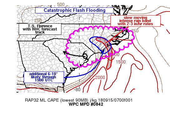
Summary...An additional 6-10 inches of rain is expected to
exacerbate ongoing catastrophic flooding/flash flooding across
portions of southeastern NC. Additional flash flooding will remain
possible for locations across eastern SC and far eastern NC given
saturated soils.

Discussion...Regional radar loops of reflectivity since 03Z has
shown the merging of 2 rain bands located east of the center of
Tropical Storm Florence into a single band which entered coastal
NC along western Onslow county. Estimated rainfall rates within
this band continue to be 2-3 in/hr per KMHX dual-pol estimates. A
6 hour precipitation observation from a RAWS site northeast of
Jacksonville reported 8.08 inches ending 08Z with radar-derived
QPE within a 1/2 inch of this total. However, the RAWS site was
not within the radar-derived QPE max, with the QPE max located
along the Onslow/Jones county border which ranged between 10-13
inches ending 08Z. These amounts appear reasonable given the slow
movement of the heavy rainfall axis observed overnight.

Florence continues a westward motion across eastern SC near 5 mph,
a slight increase in forward speed compared to during the day on
Friday.  This motion is expected to continue over the next 6 hours
via the 09Z NHC forecast advisory and recent hi-res output that is
handling Florence's speed well so far (00Z nam_nest). The
integrity of the rain band is not expected to change much over the
next few hours given availability of 1000-2000 J/kg MLCAPE just
offshore of the NC coast combined with 50-60 kt of southerly 850
mb winds providing extreme moisture transport across the
southeastern NC coastline. A slight westward drift to the rain
band is expected over the next 3-6 hours which would allow an
additional 6-10 inches of rain to impact portions of southeastern
NC from just east of Cape Fear to Sneads Ferry and locations
75-100 miles inland. Numerous reports of flooded and washed out
roads have been seen across this region already. Dangerous,
life-threatening flash flooding is expected to continue into the
late morning hours.

Otto

ATTN...WFO...AKQ...CAE...CHS...GSP...ILM...MHX...RAH...

ATTN...RFC...SERFC...

LAT...LON   36127768 35787535 34897538 33937705 33417832
            32787972 33468090 35018088 35768030 36097906
Last Updated: 504 AM EDT Sat Sep 15 2018
|


