| WPC Met Watch |
|
|
Mesoscale Precipitation Discussion: #0837 (2022) |
|
(Issued at 956 AM EDT Mon Aug 22 2022
) |
|
| MPD Selection |
|
|
|
|
|

Mesoscale Precipitation Discussion 0837
NWS Weather Prediction Center College Park MD
956 AM EDT Mon Aug 22 2022

Areas affected...Dallas-Fort Worth Metro & Along I-20

Concerning...Heavy rainfall...Flash flooding likely

Valid 221355Z - 221800Z

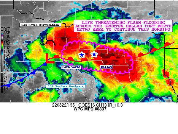
SUMMARY...Additional thunderstorms forming along a warm front and
consistent low level moisture feed ahead of a low level
circulation will continue to trigger thunderstorms containing
prolific rainfall rates. Additional flash flooding in the
immediate Dallas-Fort Worth metro area may result in life
threatening flash flooding this morning.

DISCUSSION...Thunderstorms are tracking over the Dallas-Fort Worth
metro as 15-20 knot southwesterly flow at 850mb continues to
intersect the front, leading to continued mesoscale ascent. SPC
RAP Mesoanalysis depicts a corridor of ~2.4" PWs from the metro
area on east to the ArkLaTex region. Other parameters of interest
include MUCAPE ranging between 1,000-2,000 J/kg, westerly
850-300mb mean flow oriented parallel to the front, deep warm
cloud layers >12,000' AGL, and mean cloud layer RH content >90%.
One of the key items of note in the short term is the low level
circulation north of the surface front where it continues to
generate intense thunderstorms south of Wichita Falls. The latest
RAP shows this 850mb circulation drifting ESE through late
morning, which will bring the storms south of Wichita Falls closer
to the northern periphery of metro area around midday.

The 12Z HRRR's area averaged sounding around the DFW metro at 15Z
today continue to show classic skinny CAPE soundings with ~15 knot
surface-3km shear and surface-3km SRH values of ~100 m2/s2. These
values do support the potential for these cells to contain healthy
low-level mesocyclones, further supporting these ongoing
thunderstorms as efficient rainfall producers. As the MUCAPE
becomes exhausted, convection may form more south of the DFW metro
with ongoing training moving south & east along I-20 where the the
warm front is positioned.

FLASH CREST maximum unit streamflows have rebounded to >1,000
cfs/smi near the Dallas area and storms currently moving through
the Fort Worth metro are also leading to rising streamflows >400
cfs/smi. As the storms move through, already flooded areas could
become more inundated with rainfall, as well as neighboring
communities where soils have become too saturated to soak in
anymore rainfall. Hourly rainfall rates of 2-3"/hr are very much
on the table, and with several more hours of heavy rainfall to
come, additional instances of life threatening flash flooding are
possible in and around the greater Dallas-Fort Worth metro area
and on east along I-20.

Mullinax

ATTN...WFO...FWD...SHV...

ATTN...RFC...WGRFC...NWC...

LAT...LON   33209774 33179692 32959624 32889573 32629543
            32269539 32119572 32239677 32339736 32609799
            32909800
Last Updated: 956 AM EDT Mon Aug 22 2022
|


