| WPC Met Watch |
|
|
Mesoscale Precipitation Discussion: #0834 (2020) |
|
(Issued at 245 PM EDT Wed Oct 28 2020
) |
|
| MPD Selection |
|
|
|
|
|

Mesoscale Precipitation Discussion 0834
NWS Weather Prediction Center College Park MD
245 PM EDT Wed Oct 28 2020

Areas affected...Southeast LA...Southern MS

Concerning...Heavy rainfall...Flash flooding likely

Valid 281845Z - 290045Z

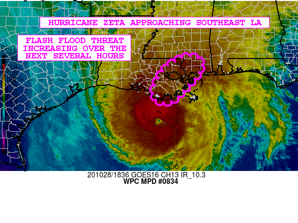
SUMMARY...Hurricane Zeta approaching southeast LA with very heavy
rainfall. The threat of flash flooding will increase this
afternoon and evening leading up to and just after landfall.

DISCUSSION...The latest GOES-16 IR 1-minute satellite imagery
shows a rather well-defined eye associated with CAT-2 Hurricane
Zeta as the storm accelerates north-northeast toward southeast LA.
Some very cold cloud tops are seen with the northern eyewall of
Zeta, and the New Orleans (KLIX) radar confirms some very intense
convection.

Heavy rainfall and embedded bands of convection north of Zeta are
beginning to advance onshore across southeast LA, and conditions
will be rapidly deteriorating over the next few hours as more
concentrated heavy rains associated with Zeta's central core begin
to arrive. A 1627Z AMSU pass captured some of the heavier rainfall
rates evolving in Zeta's northern eyewall and showed hourly rates
of near 1.75 inches/hr. However, since then the hurricane has
become even better organized with colder cloud tops, and most
likely heavier rainfall rates that are exceeding 2 inches/hr.

Zeta will continue to quickly advance north-northeast toward
southeast LA this afternoon and should make a landfall in between
21Z and 00Z. The latest HRRR-based guidance supports rainfall
amounts of 2 to 4 inches with isolated heavier amounts going
through 00Z, and while they heaviest rainfall over the next
several hours will be over southeast LA, the heavier rains will be
quick to advance into southern MS near and just after 00Z.

The threat for areas of flash flooding will increase as a result
as Zeta approaches and makes landfall, but fortunately the
accelerating nature of the storm will tend to mitigate the storm
totals somewhat and the resulting magnitude of runoff problems and
flash flooding. However, the more urbanized areas, especially
around New Orleans, will ultimately have the greatest sensitivity
and concerns for locally more significant flash flooding.

Orrison

ATTN...WFO...JAN...LIX...MOB...

ATTN...RFC...LMRFC...NWC...

LAT...LON   31098958 31078914 30698883 30208907 29598965
            29119005 28959053 29029098 29289114 30009093
            30759032
Last Updated: 244 PM EDT Wed Oct 28 2020
|


