| WPC Met Watch |
|
|
Mesoscale Precipitation Discussion: #0742 |
|
(Issued at 200 AM EDT Sat Jul 27 2024
) |
|
| MPD Selection |
|
|
|
|
|

Mesoscale Precipitation Discussion 0742
NWS Weather Prediction Center College Park MD
200 AM EDT Sat Jul 27 2024

Areas affected...Northwest Minnesota...Eastern North Dakota...

Concerning...Heavy rainfall...Flash flooding possible

Valid 270600Z - 271100Z

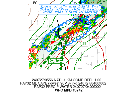
SUMMARY...Continuing upstream redevelopment along favorable
training profile/track to allow for localized rainfall totals of
3-4" and possible incidents of flash flooding through the
overnight period.

DISCUSSION...GOES-E 10.3um EIR loop along with regional RADAR has
shown cycling clusters of thunderstorms across northwest MN for
the last few hours.  Convection has been aligned along a low-level
convergence zone/stationary front from the Northwest Angle back
toward Grand Forks.  However, GOES-E WV suite shows shortwave/MCV
from earlier convective cluster is moving out of western SD into
the region and starting to provide further mid to upper level
ascent forcing via DPVA and increasing exposure to the right
entrance region of the northern stream jet streak over
south-central Canada.   Additionally, deep layer moisture pooling
has reached total PWat values in the 1.75" range but with 30kts of
slightly veering/convergence streamlines have maintained solid
flux into the parallel frontal zone.  As such, rain rates have
steadily increased with rates of 1.5-2"/hr seen across NW MN.

RAP analysis shows fairly unstable air feeding with that low level
flow and while capped, the forcing/convergence into the boundary
is sufficient for the 2000 J/kg of MLCAPE to maintain stronger
thunderstorms across the area.   There is reduction of instability
forecast with time, but should be sufficient (1000-1500 J/kg) to
further enhance/maintain upstream convection across central NDak
into the low level stationary frontal zone.  As such, a profile
for further convective training is expected to maintain over the
next few hours.  A few spots of 2"+ values have been observed and
so additional 2-3" and expanding spots of 2-5" and should overcome
naturally higher FFG values in the region.  So all considered,
flash flooding is possible across NW MN and may even intersect
with urban locales around Grand Forks over the next few hours as
the shortwave/MCV moves through.

Gallina

ATTN...WFO...FGF...

ATTN...RFC...NCRFC...NWC...

LAT...LON   48979550 48939468 48429450 47969537 47319734
            47269802 47569840 47899823 48319759 48529706
            48749650
Download in GIS format: Shapefile
| KML
Last Updated: 200 AM EDT Sat Jul 27 2024
|


