| WPC Met Watch |
|
|
Mesoscale Precipitation Discussion: #0741 |
|
(Issued at 822 PM EDT Fri Jul 26 2024
) |
|
| MPD Selection |
|
|
|
|
|

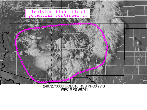
Mesoscale Precipitation Discussion 0741
NWS Weather Prediction Center College Park MD
822 PM EDT Fri Jul 26 2024

Areas affected...portions of east-central AZ and west-central NM

Concerning...Heavy rainfall...Flash flooding possible

Valid 270002Z - 270602Z

Summary...Monsoon-related flash flood potential will continue
through 05Z or so.

Discussion...Isolated to scattered thunderstorm activity has
developed in earnest across several areas from central Arizona
into central New Mexico though the afternoon.  The storms are
migrating around the periphery of mid/upper ridging across Baja
California, but with modest/weak wind fields aloft (less than 20
knots), 10-15 mph storm motions have been prevalent with most
activity.  Isolated instances of 0.5-1.0 inch/hr rain rates have
been noted, which isn't surprising given the slow storm motions
and 1 inch PW values (highest across southern Arizona).  The
overall regime supports isolated flash flood potential -
especially where heavier downpours can fall over burn scars and in
low spots/sensitive terrain.

The ongoing scenario is diurnally driven, and a gradual downtick
in convective activity is expected through sunset as nocturnal
stabilization occurs.  Some concern also exists that upscale
growth of convection into forward-propagating linear segment(s)
could occur across southern Arizona, which could pose a locally
enhanced flash flood threat given higher PW values and potentially
higher thunderstorm coverage in that vicinity.

Cook

ATTN...WFO...ABQ...EPZ...FGZ...PSR...TWC...

ATTN...RFC...ABRFC...CBRFC...WGRFC...NWC...

LAT...LON   36830835 36770585 35200485 34160482 33050530
            32330733 31680847 31520987 31661167 34251317
            35991307 36541112
Download in GIS format: Shapefile
| KML
Last Updated: 822 PM EDT Fri Jul 26 2024
|


