| WPC Met Watch |
|
|
Mesoscale Precipitation Discussion: #0740 |
|
(Issued at 459 PM EDT Fri Jul 26 2024
) |
|
| MPD Selection |
|
|
|
|
|

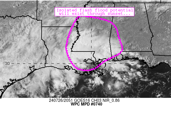
Mesoscale Precipitation Discussion 0740
NWS Weather Prediction Center College Park MD
459 PM EDT Fri Jul 26 2024

Areas affected...central/southern Mississippi into southern
Louisiana and southwestern Alabama

Concerning...Heavy rainfall...Flash flooding possible

Valid 262057Z - 270257Z

Summary...Slow-moving convective clusters continue to drift
northward while producing spots of 2-3 inch/hr rain rates on an
isolated basis.  Flash flooding is possible as storms drift toward
I-20 in central Mississippi over the next 2-4 hours.

Discussion...Scattered to numerous thunderstorms continue to drift
northward ahead of a weak mid-level disturbance centered over
Texas.  These storms were initially focused across southeastern
Louisiana, but have spread northward while locally congealing into
forward-propagating clusters extending from southwestern
Mississippi through southeastern Louisiana southeastern
Mississippi.  The storms are embedded within weak southwesterly
flow aloft (around 15 knots) and are also benefiting from
abundantly moist/unstable pre-convective air characterized by
2-2.4 inch PW values and 1500 J/kg MLCAPE.  Slow movement and
mergers have allowed for spots of 2-3.5 inch/hr rain rates to
materialize especially west of Brookhaven, MS and near Baton
Rouge, LA.  These rates are only exceeding FFG thresholds (in the
2.5-3 inch/hr range) on an isolated basis, suggestive of an
isolated flash flood threat focused in locally sensitive/low-lying
areas.

The ongoing scenario should persist for another 2-4 hours, with
storms drifting northward toward the I-20 corridor in Mississippi
over the next 1-3 hours.  Sufficient moisture/instability exists
north of I-20 for storms to persist for much of the afternoon
before a combination of widespread convective overturning and
sunset results in a gradual lessening of convective coverage
toward sunset.  This process will take several hours to play out,
however.  Flash flooding is possible through at least 02Z or so.

Cook

ATTN...WFO...BMX...JAN...LCH...LIX...LZK...MEG...MOB...

ATTN...RFC...LMRFC...SERFC...NWC...

LAT...LON   33799015 33278832 31998775 31028758 30278891
            29588990 29679114 30809189 31889190 33689112
Download in GIS format: Shapefile
| KML
Last Updated: 459 PM EDT Fri Jul 26 2024
|


