| WPC Met Watch |
|
|
Mesoscale Precipitation Discussion: #0689 |
|
(Issued at 159 AM EDT Mon Jul 22 2024
) |
|
| MPD Selection |
|
|
|
|
|

Mesoscale Precipitation Discussion 0689
NWS Weather Prediction Center College Park MD
159 AM EDT Mon Jul 22 2024

Areas affected...Northern Tennessee and much of Kentucky

Concerning...Heavy rainfall...Flash flooding possible

Valid 220600Z - 221200Z

Summary...Showers and thunderstorms will regenerate along a
convergence boundary and move slowly through the overnight hours.
Rainfall rates may exceed 2"/hr at times, leading to 2-3" of rain
with locally higher amounts. Flash flooding is possible.

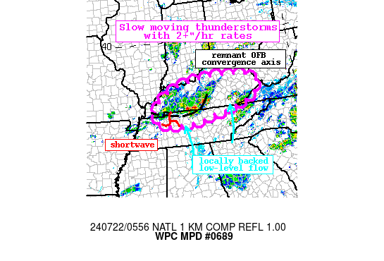
Discussion...The regional radar mosaic late tonight shows an
expansion of thunderstorms across portions of northern TN and into
southern KY. This convection is developing along a convergent
boundary that appears to be a remnant outflow boundary (OFB) from
earlier Sunday's convection, and downstream of a shortwave moving
out of northern MS/western TN. Forcing for ascent is also being
provided through the RRQ of an upper jet streak lifting into the
Mid-Atlantic, while locally backed 850mb flow noted in VWPs and
via the SPC RAP analysis is converging into the region. This LLJ,
although modest at just 10-15 kts, is drawing elevated PWs of
1.75-1.9 inches and MLCAPE of 1000 J/kg northward to support heavy
rainfall, and recent radar-estimated rain rates have eclipsed
1.5"/hr on the northern edge of the accompanying theta-e ridge.

The recent runs of the HRRR have been playing catch up to the
current activity noted on radar, but currently is initializing
quite well, and appears to be the most reasonable solution of the
available CAMs. This indicates that convection will continue to
develop overnight, especially along this convergence axis and
downstream of the shortwave where ascent will be maximized in the
favorable thermodynamic environment. HREF neighborhood
probabilities for 1"/hr (2"/hr) rainfall rates reach 40% (10%),
and storm motions could effectively be near zero at times along
this boundary. Since many of the CAMs outside of the HRRR are
struggling with the current activity, the HREF probabilities of
just 10-15% for 3"/6hrs are probably a bit low, and where these
intense rates drift along the boundary, rainfall could exceed 3"
in places, especially from north of Nashville, TN and into the
Pennyroyal Plateau. Additional convective development is possible
anywhere in the discussion area as forcing and thermodynamics
align, and repeating rounds of thunderstorms are possible, but the
heaviest rainfall should occur along this remnant OFB.

FFG is compromised across much of this region, falling to as low
as 2"/3hrs in central KY, and just 1-1.5"/3hrs in eastern KY. This
is due to 7-day rainfall that according to AHPS has been more than
150% of normal in many areas, leading to soils that are more
sensitive to runoff and flash flooding. Although HREF FFG
exceedance probabilities are modest, due at least in part to the
non-HRRR CAMs struggling, it is possible that any slow moving or
repeating storms with heavy rainfall could cause instances of
flash flooding through the early morning.


Weiss

ATTN...WFO...JKL...LMK...MEG...MRX...OHX...PAH...RLX...

ATTN...RFC...LMRFC...OHRFC...NWC...

LAT...LON   38128466 38058328 37888265 37628235 37018262
            36588381 36308501 36068602 35978694 35988771
            36138834 36708857 37238813 37638747 37998629
Download in GIS format: Shapefile
| KML
Last Updated: 159 AM EDT Mon Jul 22 2024
|


