| WPC Met Watch |
|
|
Mesoscale Precipitation Discussion: #0687 (2022) |
|
(Issued at 839 PM EDT Fri Aug 05 2022
) |
|
| MPD Selection |
|
|
|
|
|

Mesoscale Precipitation Discussion 0687
NWS Weather Prediction Center College Park MD
839 PM EDT Fri Aug 05 2022

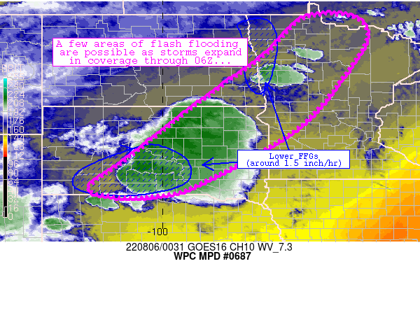
Areas affected...portions of South Dakota, eastern North Dakota,
and western Minnesota

Concerning...Heavy rainfall...Flash flooding possible

Valid 060038Z - 060638Z

Summary...Scattered thunderstorms have developed along a front
across the Northern Plains.  These storms are producing locally
heavy rainfall rates and may cause isolated instances of flash
flooding this evening.

Discussion...Deep convection has ignited along a front extending
from north-central Minnesota southwestward to near Pierre, SD.
The storms have formed within a pronounced moisture/instability
axis along and just ahead of the front characterized by 3000+ J/kg
SBCAPE and 1.5+ inch PW values.  Additionally, westerly mid-level
flow (in the 300-500mb layer) was allowing for slow (20 kt)
eastward progress of the storms, though localized backbuilding was
also noted along the front near Fargo and also south of Pierre.
The efficient rainfall processes and slow movement of the storms
were fostering a few spots of 2-3 inch/hr rainfall rates
especially south of Pierre.

Models/CAMs suggest that the ongoing convection will continue to
expand in coverage along the front, which isn't expected to move
much over the next 3-6 hours.  Areas of heavy rain rates should
increase in tandem with the expanded convective coverage.
Additionally, a few local areas within the discussion area have
FFG thresholds in the 1-1.5 inch/hr range - particularly across
southern South Dakota and along the North Dakota/Minnesota border.
 Flash flooding is a bit more likely in these areas.  FFGs are
slightly higher in the Aberdeen area (around 2.5 inch/hr rainfall
rates), suggesting a slightly lower risk of flash flooding there.

Cook

ATTN...WFO...ABR...BIS...DLH...FGF...FSD...LBF...MPX...UNR...

ATTN...RFC...MBRFC...NCRFC...NWC...

LAT...LON   48979392 48449319 47329371 45199556 43359885
            42960028 42940167 43240245 44130124 45729920
            46629800 47719650 48849535
Last Updated: 839 PM EDT Fri Aug 05 2022
|


