| WPC Met Watch |
|
|
Mesoscale Precipitation Discussion: #0685 |
|
(Issued at 849 PM EDT Sun Jul 21 2024
) |
|
| MPD Selection |
|
|
|
|
|

Mesoscale Precipitation Discussion 0685
NWS Weather Prediction Center College Park MD
849 PM EDT Sun Jul 21 2024

Areas affected...New Mexico...Adjacent Portions of Cap Rock in
TX...

Concerning...Heavy rainfall...Flash flooding possible

Valid 220050Z - 220615Z

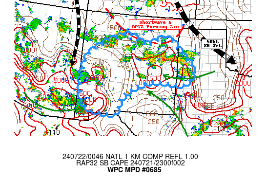
SUMMARY...Strong up/downdrafts along leading edge of stronger
outflow will continue to pose highly localized sub-hourly intense
rainfall capable of isolated 1-2" and possible flash flooding
conditions.

DISCUSSION...GOES-E WV depicts a shortwave diving south along the
south-central CO Rockies Front Range toward northeast NM and the
OK/TX panhandles providing strong DPVA across northern NM into the
TX panhandle.  Increasingly diffluent downstream flow is providing
a very strong divergence signal across E central NM and may allow
for further cyclonic strengthening of the shortwave though reduce
its forward speed into the early overnight period.  Regional RADAR
and GOES-E Visible/EIR channels show the arched band of stronger
thunderstorms from Deaf Smith/Parmer counties in TX to
Guadalupe/Torrance back northwest to McKinley county NM.  Cells
are moving into a slightly more unstable environment as upslope
flow off the Cap Rock and Pecos River Valley continues to provide
modest unstable air and slightly above average deep moisture with
total PWat values of 1 to 1.3" noted in ABQ RAOB and GPS near
Clovis, respectively.  Given remaining modestly unstable air and
strong leading edge moisture convergence, low level moisture
loading should maintain the potential for intense rain-rates
(especially further east with deeper moisture), sub-hourly rates
of 1.5"+ may allow for spots of 1-2" to quickly accumulate across
central NM and may result in localized flash flooding in prone
areas.

Stabilizing environment is expected to increase after night-fall
especially across southeast NM, but lingering instability and
convergence from ongoing upslope out of the Sonoran Desert, may
reach southwest NM prolonging scattered cells through 04-05z.
Additionally, this moisture/instability will remain across SW NM
into the mid-Rio Grande Valley; this may maintain stronger
activity along the leading edge of height-falls/DPVA described
above, allowing the convective cluster to drop through the valley
with 1-1.5" spotty totals after 06z.  While potential reduces with
loss of heating, localized flash flooding will remain possible
while convection seeks out the remaining unstable pockets.

Gallina

ATTN...WFO...ABQ...AMA...EPZ...LUB...

ATTN...RFC...ABRFC...CBRFC...WGRFC...NWC...

LAT...LON   35960603 35660554 35500484 35910373 34860252
            34420208 33700231 33610301 33640471 32860623
            32160652 31810666 31830713 32270866 34400874
            35310783 35740691 35940638
Download in GIS format: Shapefile
| KML
Last Updated: 849 PM EDT Sun Jul 21 2024
|


