| WPC Met Watch |
|
|
Mesoscale Precipitation Discussion: #0684 |
|
(Issued at 813 PM EDT Sun Jul 21 2024
) |
|
| MPD Selection |
|
|
|
|
|

Mesoscale Precipitation Discussion 0684
NWS Weather Prediction Center College Park MD
813 PM EDT Sun Jul 21 2024

Areas affected...Southern TN...Northern AL...Far Northwest GA...

Concerning...Heavy rainfall...Flash flooding likely

Valid 220015Z - 220515Z

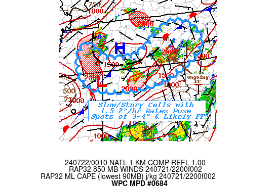
SUMMARY...Continued back-building relative stationary cell motions
on the upwind side of outflow; as well as training profile on the
southeast side continue to pose flash flooding risk into early
overnight period.  Scattered spots of 3-4" are likely to continue
localized flash flooding conditions.

DISCUSSION...Earlier convection in proximity to the stationary
front draped across Middle Tennessee has kicked out an outflow
boundary toward the west and south reinforcing the FGEN across
south-central TN.  Weak southwesterly 850mb isentropic ascent will
help to maintain/back-build storms along the western side of the
outflow boundary. Cell motions appear to be nearing equal and
opposite to the propagation to allow for localized stationary
cells. Given surface Tds to 70F and deep layer moisture in the
1.75" range, rates of 1.5-2"/hr are probable and so spots of 3-4"
will be possible before cold pool dominates and propagation to the
southwest occurs or stabilizing local environment stops the next
cycle given winds provide weak convergence/isentropic ascent over
cold pool to overcome increasing capping.  There is mixed signals
in guidance, providing low confidence, but any cells that do
maintain will pose that higher risk potential for flash flooding
given the slow motions.

Further southeast across SE TN/NW GA/N AL, stronger updrafts
continue to break through the cirrus with cooling tops below -60C
across Limestone/Madison county,AL, as well as, the more
persistent cells near Meigs/Hamilton county, TN.  Weak low to
mid-level flow and back-building forcing, has brough effective
cell motions to be less than 5kts, but also remain oriented
favorably to the deep layer flow.  Outflow/reinforced stationary
front FGEN forcing is weak as it is parallel to the mean flow, but
any cold pools generated by the ongoing convection will support
similar back-building/over-running conditions expected across
Western TN/into NW AL.  Spots of focused 3-4" totals are likely to
continue to produce flash flooding conditions through the next few
hours in to the early overnight period, when low light visibility
increases the potential for deadly consequences of crossing
flooded roads.

Gallina

ATTN...WFO...FFC...HUN...MEG...MRX...OHX...

ATTN...RFC...LMRFC...OHRFC...SERFC...NWC...

LAT...LON   36328468 35868404 35308417 34708519 34378637
            34358768 34498839 34708879 35208900 35858882
            35938849 35598816 35408774 35428656 36208545
Download in GIS format: Shapefile
| KML
Last Updated: 813 PM EDT Sun Jul 21 2024
|


