| WPC Met Watch |
|
|
Mesoscale Precipitation Discussion: #0683 |
|
(Issued at 738 PM EDT Sun Jul 21 2024
) |
|
| MPD Selection |
|
|
|
|
|

Mesoscale Precipitation Discussion 0683
NWS Weather Prediction Center College Park MD
738 PM EDT Sun Jul 21 2024

Areas affected...Northeast GA...Central/Upstate SC...Central
NC...Far South-central VA...

Concerning...Heavy rainfall...Flash flooding possible

Valid 212340Z - 220530Z

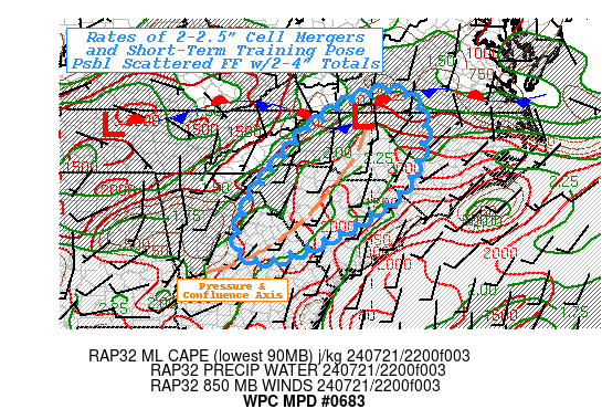
SUMMARY...Increasing convection with surge of enhanced moisture,
unstable air across Piedmont of the Carolinas.  Favorable
orientation for short-term training and cell mergers pose
localized spots of 2-4" in short duration for possible incidents
of flash flooding into the early overnight period.

DISCUSSION...Low level flow per VWP network has swung around to
more southerly across E GA/SC with further backing toward SSE
across North Carolina with 850mb winds starting to increase to
15kts in response to passing jet streak, subtle southern stream
wave within fairly unidirectional positively-tilted trough that
has been dominating the eastern third of the U.S.  Additionally, a
convectively induced wave/line of thunderstorms is moving off the
mid-slopes of the central Appalachians; combining in the vicinity
of the stalled surface front which is generally oriented across S
VA.  Scattered convection with tops breaking through broken cirrus
can be seen from W NC into the lower foothills of west-central NC.
Additionally, confluence of Gulf and Atlantic streams are
providing some enhanced convergence across the Fall-line of
central SC.  Surge of higher theta-E with the warm-advection will
increase deep layer moisture back above 2" to 2.25" and maintain
unstable air mass AoA 2000-2500 J/kg in MLCAPE even as daytime
heating wanes.

As such, convergence to the surface wave exiting the higher
terrain and in proximity to the boundary will increase convergence
and coverage of thunderstorms with strongest cells capable of
2-2.5"/hr.  Cells lifting north along the confluence trough across
the Piedmont/Fall-line may have the opportunity to train for short
duration as deep layer steering will be more south-southwest to
south; eventually merging from cells moving out of the foothills
of NC/SC.  Hourly rates may exceed FFG values given lower values
in the Piedmont (generally less than 2"...some as low as 1.5"),
though widely scattered to scattered spots of mergers/training may
reach 3-4" totals in 1-3hrs and be more likely to induce possible
flash flooding.

Gallina

ATTN...WFO...CAE...FFC...GSP...ILM...RAH...RNK...

ATTN...RFC...OHRFC...SERFC...NWC...

LAT...LON   37067929 36537874 35807870 34627921 33808035
            33258135 32758282 33198343 33868298 35158227
            36158151 36878041
Download in GIS format: Shapefile
| KML
Last Updated: 738 PM EDT Sun Jul 21 2024
|


