| WPC Met Watch |
|
|
Mesoscale Precipitation Discussion: #0682 |
|
(Issued at 350 PM EDT Sun Jul 21 2024
) |
|
| MPD Selection |
|
|
|
|
|

Mesoscale Precipitation Discussion 0682
NWS Weather Prediction Center College Park MD
350 PM EDT Sun Jul 21 2024

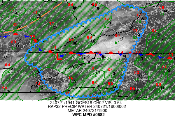
Areas affected...Southern WV...Southwest VA...Western
NC...Northeast TN...Southeast KY...Northern Upstate SC...

Concerning...Heavy rainfall...Flash flooding possible

Valid 211950Z - 220130Z

SUMMARY...Increasing convection along spines of Cumberland Plateau
and Central Appalachians with increasing moisture flux convergence
will support rates of 1.5"/hr and spots of 2-3" over the next few
hours over steep/complex terrain resulting in possible scattered
flash flooding.

DISCUSSION...Aloft a broad positive-tilt synoptic trough exists
over the Ohio Valley back southwest to Arkansas resulting in broad
southwesterly flow across the South and through the spine of the
Appalachians.  While a wave exited yesterday and scoured very deep
moisture east of the Appalachians, supporting some weak damming
across the VA Blue Ridge, low level moisture has been returning
along upslope flow across NC into SW VA with mid to upper 60s and
isolated 70/71F in the foothills.  West of the terrain, moisture
from the south has banked up through the Cumberland Plateau as the
stationary front crosses in the vicinity of the Cumberland Gap and
Tds are in the upper 60s/low 70s on that side.  Aloft, a 700mb
wave is lifting through with enhanced moisture per 700-500 CIRA
LPW and RAP analysis centered over teh area of concern.

Given a weak circulation in place though depth, there is solid
moisture convergence along most directions through SW VA/E TN/W
NC; and total PWats have trickled back above 1.5-1.7" in the lower
slopes with 1.25-1.5" at the peaks.  Solid insolation has provided
ample heating to the lower profiles to support 1500 J/kg of MLCAPE
west of the spine and starting to creep up to 1000 J/kg east of it
as far north as VA.  Solid outflow aloft and
strengthening/maintaining upslope flow (especially along the
eastern slopes) should allow for slow cell motions and increasing
rain rates up to 1.5"/hr.

Initially slow moving cells may have an hour or two  of residency
for enhanced localized totals of 1.5-2.5" possibly inducing flash
flooding in complex terrain.  Eventually cells will organize into
stronger clusters/linear features and move off the terrain to the
east, rates and totals are likely to increase to support 2-3"
totals but may move into areas of higher FFG and less slope.  As
such, scattered incidents of flash flooding are considered
possible through this evening, with greater potential further
south nearer deeper moist inflow.

Gallina

ATTN...WFO...GSP...JKL...MRX...RLX...RNK...

ATTN...RFC...LMRFC...MARFC...OHRFC...SERFC...NWC...

LAT...LON   38438049 38127973 37677978 36878020 36268049
            35648065 35058108 34878241 35188340 35608380
            36018390 36298448 36768420 37268328 37718224
            38108123
Download in GIS format: Shapefile
| KML
Last Updated: 350 PM EDT Sun Jul 21 2024
|


