| WPC Met Watch |
|
|
Mesoscale Precipitation Discussion: #0640 (2021) |
|
(Issued at 431 AM EDT Mon Jul 26 2021
) |
|
| MPD Selection |
|
|
|
|
|

Mesoscale Precipitation Discussion 0640
NWS Weather Prediction Center College Park MD
431 AM EDT Mon Jul 26 2021

Areas affected...Northeast Florida

Concerning...Heavy rainfall...Flash flooding possible

Valid 260830Z - 261330Z

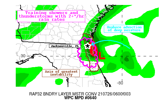
Summary...A wave of low pressure just east of the coast will lift
W/NW and onshore this morning. Bands of heavy rainfall with rates
of 2-3"/hr will train onto the coast producing 2-4" of rain with
local amounts above 5". Flash flooding is possible.

Discussion...The regional radar mosaic early this morning shows a
broad spin of reflectivity surrounding a surface low pressure just
east of Jacksonville, FL. This low is moving slowly W/NW towards
the coast, and is accompanied by deepening and expanding
convection noted by cooling cloud tops on GOES-E IR imagery. This
system is embedded within a tropical airmass, and PWs from the
recent blended-TPW product and the RAP analysis are 2-2.25" along
the First Coast of FL. Recent radar estimated rain rates have
reached 3"/hr from KJAX, and recent mesonet observations just
southeast of Jacksonville have measured 2-4" of rainfall beneath a
nearly stationary cell west of the center.

The recent CIRA LPW product indicated that deep moisture was
moving onshore the FL coast, replacing much drier air to its west.
Much of this was occurring within the 850-700mb layer where LPW
was approaching 1". This was moving westward on 850mb winds that
had climbed to 20 kts on the KJAX VWP, which are above the
850-300mb mean wind. This will act to not only enhance ascent to
increase the coverage and intensity of showers, but also to spread
instability onshore. Recent RAP analysis suggested MLCape just
north of the low was more than 2000 J/kg, and this will attempt to
push onshore through mid-morning. The greatest instability should
remain aligned to the coast, and this is where the heaviest rain
is expected, but a subtle push inland should allow for additional
expansion of rainfall to the west as well.

Within this regime, showers with rain rates of 2-3"/hr at times
will continue to train onshore before weakening with loss of
instability to the west. Additionally, as showers try to wrap
cyclonically southward around the low center, there are likely to
be periods of nearly stationary movement as shown by weak Corfidi
vectors, and as exhibited by a recent cell over St. Johns county.
The HREF probabilities for 3" in 6-hrs are as high as 50%, but
with excessive rain rates potentially sitting over isolated areas,
amounts to 5" are possible as reflected by low-end probabilities
in the HREF. FFG across this area is quite high, 3"/1hr and
4"/3hrs, for which the probability of exceedance is low. However,
torrential rain rates falling across urban areas will promote an
isolated flash flooding threat through the morning.

Weiss

ATTN...WFO...JAX...

ATTN...RFC...SERFC...NWC...

LAT...LON   30808194 30758165 30668148 30428140 30218138
            29998134 29798127 29658125 29538140 29538158
            29658184 29888199 30188207
Last Updated: 431 AM EDT Mon Jul 26 2021
|


