| WPC Met Watch |
|
|
Mesoscale Precipitation Discussion: #0635 (2021) |
|
(Issued at 148 PM EDT Sun Jul 25 2021
) |
|
| MPD Selection |
|
|
|
|
|

Mesoscale Precipitation Discussion 0635
NWS Weather Prediction Center College Park MD
148 PM EDT Sun Jul 25 2021

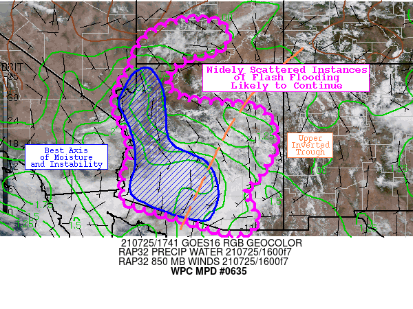
Areas affected...Much of Arizona...Southwestern Utah...Far
Southeastern Nevada

Concerning...Heavy rainfall...Flash flooding possible

Valid 251747Z - 260000Z

Summary...Widely scattered instances of flash flooding are likely
to continue across south-central portions of Arizona, expanding
northward into the higher terrain and neighboring portions of
southwestern Utah and far southeastern Nevada. Sub-hourly rainfall
rates of 1-2" will drive the flash flood threat. Localized
accumulations may also approach 2-4 inches.

Discussion...Recent trends via KIWA (Phoenix) radar indicate an
expanding flash flood threat late this morning within an area of
deep moisture convergence, driven by a decaying upper-level low
(gradually becoming more of an open inverted trough axis). The
mesoscale environment is characterized by precipitable water
standard deviations of +3 (near or exceeding 2.0 inches) and SB
CAPE of 1000-2000 J/kg. The best moisture and instability axis
currently aligns over southeastern Arizona, but is anticipated to
expand northward into the higher terrain of north-central Arizona
and into neighboring portions of southwestern Utah and far
southeastern Nevada amid daytime heating. Convective activity has
been capable of sub-hourly rainfall rates of 1-2" and has quickly
led to rapid runoff over already highly saturated soils. Washes
that are normally dry may quickly fill with fast moving water due
to these rapid rainfall accumulations, though the spatial extent
of the heaviest downpours is expected to remain fairly limited.

The latest hi-res CAM guidance (12z HREF suite and more recent
HRRR runs) support the northward expansion of the flash flood
threat this afternoon as mostly clear skies to the north are
allowing for significant destabilization amid peak daytime
heating. SB CAPE values are forecast to reach as high as 2000-4000
J/kg between Flagstaff and Las Vegas, fueling new vigorous
convective initiation. The aforementioned models support localized
accumulations of 2-4 inches, while 3-hr FFG is mainly near 2
inches. Many locations have already received plentiful rainfall
throughout the past week as well, so FFG in general may also be a
bit overdone. Washes, burn scars, and metropolitan areas should
pay close attention to the evolving flash flood threat through the
afternoon hours.

Churchill

ATTN...WFO...FGZ...PSR...SLC...TWC...VEF...

ATTN...RFC...CBRFC...NWC...

LAT...LON   38461179 38291109 37731105 37401147 37221236
            36691303 36121296 35861266 35711218 35601091
            35380981 34370936 33240987 32721039 32271025
            31630996 31301030 31271065 31321111 31461153
            31711238 32011346 32371447 32691445 33071443
            33391441 33761423 34181419 34361422 34901443
            35441472 36081467 36751425 37251409 37761381
            38211321 38421258
Last Updated: 148 PM EDT Sun Jul 25 2021
|


